Difference between revisions of "2013-03-07 55 37"
From Geohashing
imported>Vb (→Location) |
imported>FippeBot m (Location) |
||
| (5 intermediate revisions by one other user not shown) | |||
| Line 12: | Line 12: | ||
| lat=55 | | lat=55 | ||
| lon=37 | | lon=37 | ||
| − | | date=2013-03- | + | | date=2013-03-07 |
}} | }} | ||
| Line 19: | Line 19: | ||
== Location == | == Location == | ||
<!-- where you've surveyed the hash to be --> | <!-- where you've surveyed the hash to be --> | ||
| − | In Mitino district. | + | In Mitino district, in the park. |
== Participants == | == Participants == | ||
<!-- who attended: If you link to your wiki user name in this section, your expedition will be picked up by the various statistics generated for geohashing. You may use three tildes ~ as a shortcut to automatically insert the user signature of the account you are editing with. | <!-- who attended: If you link to your wiki user name in this section, your expedition will be picked up by the various statistics generated for geohashing. You may use three tildes ~ as a shortcut to automatically insert the user signature of the account you are editing with. | ||
--> | --> | ||
| − | + | [[User:Vb|vb]] | |
| − | |||
| − | |||
== Expedition == | == Expedition == | ||
<!-- how it all turned out. your narrative goes here. --> | <!-- how it all turned out. your narrative goes here. --> | ||
| − | + | The weather was very nice - bright sun, almost no wind, temperature a bit higher than zero. | |
| − | |||
| − | |||
== Photos == | == Photos == | ||
| Line 39: | Line 35: | ||
--> | --> | ||
<gallery perrow="5"> | <gallery perrow="5"> | ||
| + | Image:2013-03-07_55_37_07032013742.jpg | from the Metro station, mixed up the directions and walked almost 180° away from the hash -- ~1km to the hash | ||
| + | Image:2013-03-07 07032013744.jpg | park's strong bureaucratic tradition: "place for sledding", "place for skiing" -- ~250m to the hash | ||
| + | Image:2013-03-07_07032013745.jpg | frozen pond, ~250m to the hash | ||
| + | Image:2013-03-07 07032013747.jpg | GPS precision | ||
| + | Image:2013-03-07 07032013748.jpg | getting closer to the hash, suddenly snow became much deeper. risk of drowning | ||
| + | Image:2013-03-07 07032013750.jpg | ~70m from the hash | ||
| + | Image:2013-03-07 07032013751.jpg | church built in 2004, not in [http://en.wikipedia.org/wiki/Kizhi_Pogost 17th century] -- ~500m from the hash | ||
| + | Image:2013-03-07_07032013756.jpg | ~800m from the hash | ||
</gallery> | </gallery> | ||
| Line 46: | Line 50: | ||
| − | |||
| − | |||
| − | |||
| − | |||
| − | |||
| − | |||
| − | |||
| − | |||
[[Category:Expeditions]] | [[Category:Expeditions]] | ||
| − | |||
[[Category:Expeditions with photos]] | [[Category:Expeditions with photos]] | ||
| − | |||
| − | |||
| − | |||
| − | |||
| − | |||
[[Category:Coordinates reached]] | [[Category:Coordinates reached]] | ||
| − | + | [[Category:Land geohash achievement]] | |
| − | + | [[Category:Public transport geohash achievement]] | |
| − | + | [[Category:Consecutive geohash achievement]] | |
| − | [[Category: | + | {{location|RU|MOW}} |
| − | |||
| − | |||
| − | [[Category: | ||
| − | |||
| − | |||
| − | [[Category: | ||
| − | |||
| − | |||
| − | |||
| − | |||
| − | |||
| − | |||
| − | |||
| − | |||
Latest revision as of 01:19, 14 August 2019
| Thu 7 Mar 2013 in 55,37: 55.8385272, 37.3639408 geohashing.info google osm bing/os kml crox |
Location
In Mitino district, in the park.
Participants
Expedition
The weather was very nice - bright sun, almost no wind, temperature a bit higher than zero.
Photos
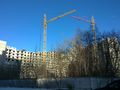
from the Metro station, mixed up the directions and walked almost 180° away from the hash -- ~1km to the hash
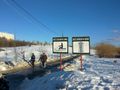
park's strong bureaucratic tradition: "place for sledding", "place for skiing" -- ~250m to the hash
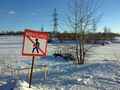
frozen pond, ~250m to the hash
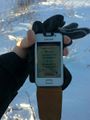
GPS precision

getting closer to the hash, suddenly snow became much deeper. risk of drowning
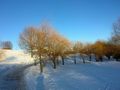
~70m from the hash
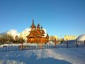
church built in 2004, not in 17th century -- ~500m from the hash
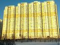
~800m from the hash


