Difference between revisions of "2013-03-09 42 -72"
imported>Toddcesere (→Achievements) |
imported>FippeBot m (Location) |
||
| (4 intermediate revisions by 2 users not shown) | |||
| Line 31: | Line 31: | ||
== Tracklog == | == Tracklog == | ||
| − | + | [https://maps.google.com/?q=http:%2F%2Fshare.gps.motionxlive.com%2Fshr%2Fx%2Fkmz%2F71dd610e7b75d7e7f55e7896f2ada0d0&ll=42.331937,-72.643458&spn=0.002685,0.004994&t=w&z=18&iwloc=lyrftr:kml:cuzKXlA9HZBP66AM2lR-clbnUMJtS_ktQUHuA8oohF1EoqFEtV5dgUJhomNcJhwoT,g36ca46cffa4bf718,42.331855,-72.64454 Google Map] | |
| − | == Photos == | + | == Photos == |
| − | |||
| − | |||
| − | |||
| − | |||
<gallery perrow="5"> | <gallery perrow="5"> | ||
| + | Image:2013-03-09_42_-72_todd.JPG | Todd | ||
| + | Image:2013-03-09_42_-72_phoebe.JPG | Phoebe | ||
| + | Image:2013-03-09_42_-72_bike_path_east.JPG | Northampton Bikeway, facing east towards town. | ||
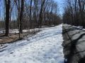
| + | Image:2013-03-09_42_-72_bike_path_west.JPG | Northampton Bikeway, facing west, towards Florence. | ||
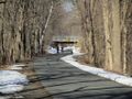
| + | Image:2013-03-09_42_-72_culvert.JPG | Near the geohash, a culvert that was probably broken apart during heavy rains. | ||
</gallery> | </gallery> | ||
== Achievements == | == Achievements == | ||
{{#vardefine:ribbonwidth|800px}} | {{#vardefine:ribbonwidth|800px}} | ||
| − | + | ||
{{Walk geohash | {{Walk geohash | ||
| latitude = 42 | | latitude = 42 | ||
| Line 59: | Line 60: | ||
}} | }} | ||
| + | {{Land geohash | ||
| + | | latitude = 42 | ||
| + | | longitude = -72 | ||
| + | | date = 2013-03-09 | ||
| + | | name = [[User:Phoebemathews|Phoebe]] and [[User:Toddcesere|Todd]] | ||
| + | | distance = 1.8km | ||
| + | }} | ||
| + | |||
| + | [[Category:Coordinates reached by Toddcesere]] | ||
[[Category:Expeditions]] | [[Category:Expeditions]] | ||
[[Category:Expeditions with photos]] | [[Category:Expeditions with photos]] | ||
[[Category:Coordinates reached]] | [[Category:Coordinates reached]] | ||
| + | {{location|US|MA|HS}} | ||
Latest revision as of 01:21, 14 August 2019
| Sat 9 Mar 2013 in 42,-72: 42.3306481, -72.6416891 geohashing.info google osm bing/os kml crox |
Location
Within a few feet of the Northampton Bikeway pavement between Adare Pl and Hayes Ave, and behind Lander Grinspoon Academy, near downtown Northampton.
Participants
Plans
Todd and Phoebe planned (without posting here) to walk from Meadowbrook Apartments on the bike path.
Expedition
Todd and Phoebe walked directly from their home, through the meadow and over the brook to the bike path. They walked about a mile down the path to the geohash, took pictures, walked off the bike path through some brambles, walked back towards home, back through the meadow and over the brook, and back home.
Tracklog
Photos
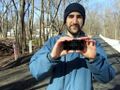
Todd
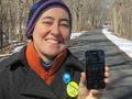
Phoebe
Northampton Bikeway, facing east towards town.
Northampton Bikeway, facing west, towards Florence.
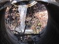
Near the geohash, a culvert that was probably broken apart during heavy rains.


Achievements
Todd earned the Walk geohash Achievement
|
Phoebe earned the Walk geohash Achievement
|
Phoebe and Todd earned the Land geohash achievement
|