Difference between revisions of "2013-03-19 33 -116"
From Geohashing
imported>LucasBrown (→Expedition) |
imported>FippeBot m (Location) |
||
| (3 intermediate revisions by 2 users not shown) | |||
| Line 14: | Line 14: | ||
<gallery perrow="5"> | <gallery perrow="5"> | ||
Image:2013-03-19_33_-116_10-16-46-661.jpg | Geohash Droid details page at the hashpoint | Image:2013-03-19_33_-116_10-16-46-661.jpg | Geohash Droid details page at the hashpoint | ||
| − | |||
Image:2013-03-19_33_-116_10-25-22-479.jpg | Geohash Droid map at the hashpoint [http://www.openstreetmap.org/?lat=32.97717360&lon=-117.05282790&zoom=16&layers=B000FTF @32.9772,-117.0528] | Image:2013-03-19_33_-116_10-25-22-479.jpg | Geohash Droid map at the hashpoint [http://www.openstreetmap.org/?lat=32.97717360&lon=-117.05282790&zoom=16&layers=B000FTF @32.9772,-117.0528] | ||
</gallery> | </gallery> | ||
| − | |||
| − | |||
| − | |||
| − | |||
| − | |||
[[Category:Expeditions]] | [[Category:Expeditions]] | ||
[[Category:Expeditions with photos]] | [[Category:Expeditions with photos]] | ||
[[Category:Expedition without GPS]] | [[Category:Expedition without GPS]] | ||
[[Category:Coordinates reached]] | [[Category:Coordinates reached]] | ||
| + | {{location|US|CA|SD}} | ||
Latest revision as of 01:28, 14 August 2019
| Tue 19 Mar 2013 in 33,-116: 33.2856243, -116.6657320 geohashing.info google osm bing/os kml crox |
Location
On the southeastern side of a hillock across the road from the Warner Springs Gliderport
Participants
Expedition
Drove out to the gliderport, parked across the road from it at the closest vehicular approach to the hashpoint (about 45 meters away), then walked to the hashpoint. Remembered the existence of a recent hashpoint (2012-08-01) in the vicinity; visited it for old times' sake by following Lost Valley Road. Returned to the car via a different route following the ridgeline of another hillock.
Photos
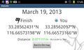
Geohash Droid details page at the hashpoint
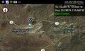
Geohash Droid map at the hashpoint @32.9772,-117.0528

