Difference between revisions of "2013-03-24 38 -76"
From Geohashing
imported>OfficeLinebacker (Created page with "I'm almost certainly going to go for this one, then try for the one in the other DC Graticule.") |
imported>FippeBot m (Location) |
||
| (13 intermediate revisions by 2 users not shown) | |||
| Line 1: | Line 1: | ||
| − | + | <!-- If you did not specify these parameters in the template, please substitute appropriate values for IMAGE, LAT, LON, and DATE (YYYY-MM-DD format) | |
| + | |||
| + | [[Image:{{{image|IMAGE}}}|thumb|left]] | ||
| + | |||
| + | Remove this section if you don't want an image at the top (left) of your report. You should remove the "Image:" or "File:" | ||
| + | tag from your image file name, and replace the all upper-case word IMAGE in the above line. | ||
| + | |||
| + | And DON'T FORGET to add your expedition and the best photo you took to the gallery on the Main Page! We'd love to read your report, but that means we first have to discover it! :) | ||
| + | --> | ||
| + | {{meetup graticule | ||
| + | | lat=38 | ||
| + | | lon=-76 | ||
| + | | date=2013-03-24 | ||
| + | }} | ||
| + | |||
| + | |||
| + | __NOTOC__ | ||
| + | == Location == | ||
| + | |||
| + | Near what appears to be a training horse racing track in Davidsonville, MD | ||
| + | |||
| + | == Participants == | ||
| + | |||
| + | * [[User:OfficeLinebacker|OfficeLinebacker]] | ||
| + | * Allison | ||
| + | |||
| + | == Plans == | ||
| + | |||
| + | |||
| + | The plan is to leave from Rockville/Kensington, and go to this one, then circle around the bottom arc of the DC Beltway to the one for DC West, which is in Haymarket, VA: [[2013-03-24_38_-77]] | ||
| + | |||
| + | == Expedition == | ||
| + | |||
| + | We got there. Area of lots of farms--horses, cows, sheep. This is some kind of practice track for horse racing. Now enroute to the geohash location in the neighboring graticule. | ||
| + | |||
| + | == Tracklog == | ||
| + | <!-- if your GPS device keeps a log, you may post a link here --> | ||
| + | |||
| + | == Photos == | ||
| + | |||
| + | <gallery perrow="5"> | ||
| + | Image:2013-03-24_38_-76_13-32-20-265.jpg | Silly grins [http://www.openstreetmap.org/?lat=38.80640460&lon=-76.98960377&zoom=16&layers=B000FTF @38.8064,-76.9896] | ||
| + | Image:2013-03-24_38_-76_13-33-15-552.jpg | The actual location was right on the fence line. Success! [http://www.openstreetmap.org/?lat=38.80084923&lon=-77.00392210&zoom=16&layers=B000FTF @38.8008,-77.0039] | ||
| + | </gallery> | ||
| + | |||
| + | == Achievements == | ||
| + | {{#vardefine:ribbonwidth|800px}} | ||
| + | |||
| + | {{Multihash | ||
| + | | latitude1 = 38 | ||
| + | | longitude1 = -76 | ||
| + | | latitude2 = 38 | ||
| + | | longitude2 = -77 | ||
| + | | date = 2013-03-24 | ||
| + | | name = OfficeLinebacker | ||
| + | }} | ||
| + | |||
| + | {{Tron | ||
| + | | latitude = 38 | ||
| + | | longitude = -76 | ||
| + | | date = 2013-03-24 | ||
| + | | tracklog = http://goo.gl/maps/zMslS | ||
| + | | possessive = His | ||
| + | | name = OfficeLinebacker | ||
| + | }} | ||
| + | |||
| + | {{Land geohash | ||
| + | | latitude = 38 | ||
| + | | longitude = -76 | ||
| + | | date = 2013-03-24 | ||
| + | | name = OfficeLinebacker | ||
| + | }} | ||
| + | |||
| + | |||
| + | [[Category:Expeditions]] | ||
| + | |||
| + | [[Category:Expeditions with photos]] | ||
| + | [[Category:Coordinates reached]] | ||
| + | {{location|US|MD|AN}} | ||
Latest revision as of 01:32, 14 August 2019
| Sun 24 Mar 2013 in 38,-76: 38.9251623, -76.6613839 geohashing.info google osm bing/os kml crox |
Location
Near what appears to be a training horse racing track in Davidsonville, MD
Participants
- OfficeLinebacker
- Allison
Plans
The plan is to leave from Rockville/Kensington, and go to this one, then circle around the bottom arc of the DC Beltway to the one for DC West, which is in Haymarket, VA: 2013-03-24_38_-77
Expedition
We got there. Area of lots of farms--horses, cows, sheep. This is some kind of practice track for horse racing. Now enroute to the geohash location in the neighboring graticule.
Tracklog
Photos

Silly grins @38.8064,-76.9896
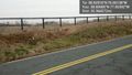
The actual location was right on the fence line. Success! @38.8008,-77.0039


Achievements
OfficeLinebacker earned the Multihash Achievement
|
OfficeLinebacker earned the Tron achievement
|
OfficeLinebacker earned the Land geohash achievement
|