Difference between revisions of "2013-03-24 38 -77"
From Geohashing
imported>OfficeLinebacker (→Achievements) |
imported>Jiml m (Fix result codes) |
||
| Line 16: | Line 16: | ||
}} | }} | ||
| − | + | ||
__NOTOC__ | __NOTOC__ | ||
== Location == | == Location == | ||
| − | + | ||
Right off a street in the foothills of a mountain range in Haymarket, VA | Right off a street in the foothills of a mountain range in Haymarket, VA | ||
== Participants == | == Participants == | ||
| − | |||
| − | |||
* [[User:OfficeLinebacker|OfficeLinebacker]] | * [[User:OfficeLinebacker|OfficeLinebacker]] | ||
| Line 30: | Line 28: | ||
== Plans == | == Plans == | ||
| − | + | ||
My girlfriend and I plan to do this one after the Washington DC East one. | My girlfriend and I plan to do this one after the Washington DC East one. | ||
| Line 40: | Line 38: | ||
== Expedition == | == Expedition == | ||
| − | + | ||
This was a cool area. It's inside a community called the Bull Run Mountain Civic Association. We had to wind up steep roads with multiple switchbacks to get there. The View was really nice. It was also quite cold. This is the website of the neighborhood organization: http://www.brmca.net/ | This was a cool area. It's inside a community called the Bull Run Mountain Civic Association. We had to wind up steep roads with multiple switchbacks to get there. The View was really nice. It was also quite cold. This is the website of the neighborhood organization: http://www.brmca.net/ | ||
| Line 47: | Line 45: | ||
== Photos == | == Photos == | ||
| − | + | ||
| − | |||
| − | |||
<gallery perrow="5"> | <gallery perrow="5"> | ||
| − | |||
Image:2013-03-24_38_-77_14-41-42-241.jpg | Silly grin [http://www.openstreetmap.org/?lat=38.92513037&lon=-77.66129408&zoom=16&layers=B000FTF @38.9251,-77.6613] | Image:2013-03-24_38_-77_14-41-42-241.jpg | Silly grin [http://www.openstreetmap.org/?lat=38.92513037&lon=-77.66129408&zoom=16&layers=B000FTF @38.9251,-77.6613] | ||
| − | |||
Image:2013-03-24_38_-77_14-42-03-833.jpg | The view [http://www.openstreetmap.org/?lat=38.92509930&lon=-77.66124663&zoom=16&layers=B000FTF @38.9251,-77.6612] | Image:2013-03-24_38_-77_14-42-03-833.jpg | The view [http://www.openstreetmap.org/?lat=38.92509930&lon=-77.66124663&zoom=16&layers=B000FTF @38.9251,-77.6612] | ||
</gallery> | </gallery> | ||
| Line 59: | Line 53: | ||
== Achievements == | == Achievements == | ||
{{#vardefine:ribbonwidth|800px}} | {{#vardefine:ribbonwidth|800px}} | ||
| − | + | ||
{{Multihash | {{Multihash | ||
| latitude1 = 38 | | latitude1 = 38 | ||
| Line 67: | Line 61: | ||
| date = 2013-03-24 | | date = 2013-03-24 | ||
| name = OfficeLinebacker | | name = OfficeLinebacker | ||
| − | |||
}} | }} | ||
| Line 79: | Line 72: | ||
}} | }} | ||
| − | + | {{Land geohash | |
| − | + | | latitude = 38 | |
| − | + | | longitude = -77 | |
| + | | date = 2013-03-24 | ||
| + | | name = OfficeLinebacker | ||
| + | }} | ||
| − | [[Category: | + | [[Category:Expeditions]] |
| − | |||
| − | |||
| − | |||
| − | |||
| − | |||
| − | |||
| − | |||
| − | |||
[[Category:Expeditions with photos]] | [[Category:Expeditions with photos]] | ||
| − | |||
| − | |||
| − | |||
| − | |||
| − | |||
[[Category:Coordinates reached]] | [[Category:Coordinates reached]] | ||
| − | |||
| − | |||
| − | |||
| − | |||
| − | |||
| − | |||
| − | |||
| − | |||
| − | |||
| − | |||
| − | |||
| − | |||
| − | |||
| − | |||
| − | |||
| − | |||
| − | |||
| − | |||
Revision as of 05:10, 25 March 2013
| Sun 24 Mar 2013 in 38,-77: 38.9251623, -77.6613839 geohashing.info google osm bing/os kml crox |
Location
Right off a street in the foothills of a mountain range in Haymarket, VA
Participants
- OfficeLinebacker
- Girlfriend
Plans
My girlfriend and I plan to do this one after the Washington DC East one.
Coming from Rockville, we will circumnavigate the Beltway in so doing.
Expedition
This was a cool area. It's inside a community called the Bull Run Mountain Civic Association. We had to wind up steep roads with multiple switchbacks to get there. The View was really nice. It was also quite cold. This is the website of the neighborhood organization: http://www.brmca.net/
Tracklog
Photos

Silly grin @38.9251,-77.6613
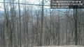
The view @38.9251,-77.6612


Achievements
OfficeLinebacker earned the Multihash Achievement
|
OfficeLinebacker earned the Tron achievement
|
OfficeLinebacker earned the Land geohash achievement
|