Difference between revisions of "2013-03-25 39 -77"
imported>OfficeLinebacker (Created page with "Depending on traffic, I may try to get there this evening before sunset. Would leave Rockville at 5.") |
imported>FippeBot m (Location) |
||
| (14 intermediate revisions by 5 users not shown) | |||
| Line 1: | Line 1: | ||
| + | {{meetup graticule | ||
| + | | lat=39 | ||
| + | | lon=-77 | ||
| + | | date=2013-03-25 | ||
| + | }} | ||
| + | |||
| + | <!-- edit as necessary --> | ||
| + | __NOTOC__ | ||
| + | == Location == | ||
| + | <!-- where you've surveyed the hash to be --> | ||
| + | About a hundred feet off Evergreen Mills Rd in Leesburg, VA | ||
| + | |||
| + | == Participants == | ||
| + | <!-- who attended: If you link to your wiki user name in this section, your expedition will be picked up by the various statistics generated for geohashing. You may use three tildes ~ as a shortcut to automatically insert the user signature of the account you are editing with. | ||
| + | --> | ||
| + | * [[User:OfficeLinebacker|OfficeLinebacker]] | ||
| + | |||
| + | == Plans == | ||
| + | <!-- what were the original plans --> | ||
| + | |||
Depending on traffic, I may try to get there this evening before sunset. Would leave Rockville at 5. | Depending on traffic, I may try to get there this evening before sunset. Would leave Rockville at 5. | ||
| + | *On my way there right now 45 minutes -- [[User:OfficeLinebacker|OfficeLinebacker]] ([[User talk:OfficeLinebacker|talk]]) [http://www.openstreetmap.org/?lat=39.07464123&lon=-77.16409207&zoom=16&layers=B000FTF @39.0746,-77.1641] 17:14, 25 March 2013 (EDT) | ||
| + | |||
| + | == Expedition == | ||
| + | <!-- how it all turned out. your narrative goes here. --> | ||
| + | Today was a snow day for much of the area. I had to work until 5 and I figured maybe there would be light traffic. I checked the cameras along the route at 5 and decided to go for it. I lit up a cigar and set out. From the map it looked like Evergreen Mill was a divided highway and the geohash point was in the middle of the southbound lanes. Once I got there I realized that the road is a narrow two lane blacktop with minimal shoulders. So I pulled over and put two wheels in a watery ditch--thanks to 4 wheel drive. I got out and started wandering. The clear patch was due to clearing a path for the power lines which run parallel to the road. I wandered around in the woods watching my phone until the numbers turned green. Success! | ||
| + | |||
| + | == Tracklog == | ||
| + | <!-- if your GPS device keeps a log, you may post a link here --> | ||
| + | |||
| + | == Photos == | ||
| + | <!-- Insert pictures between the gallery tags using the following format: | ||
| + | Image:2012-##-## ## ## Alpha.jpg | Witty Comment | ||
| + | --> | ||
| + | <gallery perrow="5"> | ||
| + | Image:2013-03-25_39_-77_18-06-02-584.jpg | Made it! [http://www.openstreetmap.org/?lat=39.01085543&lon=-77.57442210&zoom=16&layers=B000FTF @39.0109,-77.5744] | ||
| + | Image:2013-03-25_39_-77_18-08-46-078.jpg | Thank goodness for 4 wheel drive. [http://www.openstreetmap.org/?lat=39.01098100&lon=-77.57395093&zoom=16&layers=B000FTF @39.0110,-77.5740] | ||
| + | Image:2013-03-25_39_-77_18-09-10-126.jpg | The view. [http://www.openstreetmap.org/?lat=39.01099087&lon=-77.57397577&zoom=16&layers=B000FTF @39.0110,-77.5740] | ||
| + | </gallery> | ||
| + | |||
| + | == Achievements == | ||
| + | {{#vardefine:ribbonwidth|800px}} | ||
| + | <!-- Add any achievement ribbons you earned below, or remove this section --> | ||
| + | |||
| + | * Land geohash | ||
| + | |||
| + | {{consecutive geohash 2 | count = 3 | latitude = 38 | longitude = -76 | date = 2013-03-23 | name = OfficeLinebacker }} | ||
| + | |||
| + | [[Category:Expeditions]] | ||
| + | [[Category:Expeditions with photos]] | ||
| + | [[Category:Coordinates reached]] | ||
| + | {{location|US|VA|LD}} | ||
Latest revision as of 01:34, 14 August 2019
| Mon 25 Mar 2013 in 39,-77: 39.0108820, -77.5744300 geohashing.info google osm bing/os kml crox |
Location
About a hundred feet off Evergreen Mills Rd in Leesburg, VA
Participants
Plans
Depending on traffic, I may try to get there this evening before sunset. Would leave Rockville at 5.
- On my way there right now 45 minutes -- OfficeLinebacker (talk) @39.0746,-77.1641 17:14, 25 March 2013 (EDT)
Expedition
Today was a snow day for much of the area. I had to work until 5 and I figured maybe there would be light traffic. I checked the cameras along the route at 5 and decided to go for it. I lit up a cigar and set out. From the map it looked like Evergreen Mill was a divided highway and the geohash point was in the middle of the southbound lanes. Once I got there I realized that the road is a narrow two lane blacktop with minimal shoulders. So I pulled over and put two wheels in a watery ditch--thanks to 4 wheel drive. I got out and started wandering. The clear patch was due to clearing a path for the power lines which run parallel to the road. I wandered around in the woods watching my phone until the numbers turned green. Success!
Tracklog
Photos

Made it! @39.0109,-77.5744
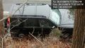
Thank goodness for 4 wheel drive. @39.0110,-77.5740
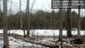
The view. @39.0110,-77.5740


Achievements
- Land geohash
OfficeLinebacker earned the Consecutive geohash achievement
|