Difference between revisions of "2013-03-27 38 -76"
imported>OfficeLinebacker ([live picture] [http://www.openstreetmap.org/?lat=38.53578655&lon=-76.10906825&zoom=16&layers=B000FTF @38.5358,-76.1091]) |
imported>FippeBot m (Location) |
||
| (5 intermediate revisions by 3 users not shown) | |||
| Line 1: | Line 1: | ||
| − | |||
| − | |||
| − | |||
| − | |||
| − | |||
| − | |||
| − | |||
| − | |||
| − | |||
| − | |||
{{meetup graticule | {{meetup graticule | ||
| lat=38 | | lat=38 | ||
| Line 19: | Line 9: | ||
== Location == | == Location == | ||
<!-- where you've surveyed the hash to be --> | <!-- where you've surveyed the hash to be --> | ||
| + | 1000 feet down a drainage ditch from the road in Cambridge, MD | ||
== Participants == | == Participants == | ||
<!-- who attended: If you link to your wiki user name in this section, your expedition will be picked up by the various statistics generated for geohashing. You may use three tildes ~ as a shortcut to automatically insert the user signature of the account you are editing with. | <!-- who attended: If you link to your wiki user name in this section, your expedition will be picked up by the various statistics generated for geohashing. You may use three tildes ~ as a shortcut to automatically insert the user signature of the account you are editing with. | ||
--> | --> | ||
| + | [[User:OfficeLinebacker|OfficeLinebacker]] ([[User talk:OfficeLinebacker|talk]])OfficeLinebacker | ||
== Plans == | == Plans == | ||
| Line 31: | Line 23: | ||
| − | + | When I found the place on the road where I intended to pull over at 5 pm, there were three guys in a pickup truck rolling up a big red hose that had been laid out along the shoulder. Like I've seen in the past to provide temporary water service. I did a U-turn and parked on the other side of the road. I hopped the drainage ditch that was between the road and the land and set out. The drainage ditch was gross and full of green algae. Depending on the location, one or the other side of the ditch was easier going so I hopped it twice on the way to the geohash. The actual location is on the edge of a forest. There were lots of thorned, viney plants which grasped at my clothing and boots. | |
| + | |||
| + | Once I got there, I snapped the pic, and was ready to head home after a long day of geohashing. I left home at 10 am, three geohash points ago. It was not 5:30 and I was ready to head home--it was 2 1/2 hours away. I got home at 8pm. | ||
| + | |||
== Tracklog == | == Tracklog == | ||
<!-- if your GPS device keeps a log, you may post a link here --> | <!-- if your GPS device keeps a log, you may post a link here --> | ||
| Line 52: | Line 47: | ||
<!-- Add any achievement ribbons you earned below, or remove this section --> | <!-- Add any achievement ribbons you earned below, or remove this section --> | ||
| − | |||
| − | |||
| − | |||
| − | |||
| − | |||
| − | |||
| − | |||
| − | |||
| − | |||
| − | |||
| − | |||
[[Category:Expeditions]] | [[Category:Expeditions]] | ||
| − | |||
[[Category:Expeditions with photos]] | [[Category:Expeditions with photos]] | ||
| − | |||
| − | |||
| − | |||
| − | |||
| − | |||
[[Category:Coordinates reached]] | [[Category:Coordinates reached]] | ||
| − | + | {{location|US|MD|DO}} | |
| − | |||
| − | |||
| − | |||
| − | |||
| − | |||
| − | |||
| − | |||
| − | |||
| − | |||
| − | |||
| − | |||
| − | |||
| − | |||
| − | |||
| − | |||
| − | |||
| − | |||
Latest revision as of 05:39, 6 August 2019
| Wed 27 Mar 2013 in 38,-76: 38.5357028, -76.1074312 geohashing.info google osm bing/os kml crox |
Location
1000 feet down a drainage ditch from the road in Cambridge, MD
Participants
OfficeLinebacker (talk)OfficeLinebacker
Plans
Expedition
When I found the place on the road where I intended to pull over at 5 pm, there were three guys in a pickup truck rolling up a big red hose that had been laid out along the shoulder. Like I've seen in the past to provide temporary water service. I did a U-turn and parked on the other side of the road. I hopped the drainage ditch that was between the road and the land and set out. The drainage ditch was gross and full of green algae. Depending on the location, one or the other side of the ditch was easier going so I hopped it twice on the way to the geohash. The actual location is on the edge of a forest. There were lots of thorned, viney plants which grasped at my clothing and boots.
Once I got there, I snapped the pic, and was ready to head home after a long day of geohashing. I left home at 10 am, three geohash points ago. It was not 5:30 and I was ready to head home--it was 2 1/2 hours away. I got home at 8pm.
Tracklog
Photos

Le silly grin @38.5357,-76.1074
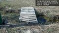
Helpful pallets to cross ditch @38.5357,-76.1074


