Difference between revisions of "2013-03-27 39 -76"
imported>Palmpje m (Cleaning up the New Report category) |
imported>GeorgDerReisende |
||
| Line 1: | Line 1: | ||
| − | |||
| − | |||
| − | |||
| − | |||
| − | |||
| − | |||
| − | |||
| − | |||
| − | |||
| − | |||
{{meetup graticule | {{meetup graticule | ||
| lat=39 | | lat=39 | ||
| Line 66: | Line 56: | ||
<!-- Add any achievement ribbons you earned below, or remove this section --> | <!-- Add any achievement ribbons you earned below, or remove this section --> | ||
| − | |||
| − | |||
[[Category:Expeditions]] | [[Category:Expeditions]] | ||
[[Category:Expeditions with photos]] | [[Category:Expeditions with photos]] | ||
[[Category:Coordinates reached]] | [[Category:Coordinates reached]] | ||
Revision as of 19:11, 15 November 2014
| Wed 27 Mar 2013 in 39,-76: 39.5357028, -76.1074312 geohashing.info google osm bing/os kml crox |
Location
On a parade ground on an Army Reserve base in Havre de Grace, MD
Participants
OfficeLinebacker (talk)OfficeLinebacker
Plans
Expedition
I headed for this once after checking in at the hashpoint in Westminster. I stopped at a Wawa on the way for coffee, a sub, and cheap gas. When I approached, I realized there was a security checkpoint at the entrance to the area that I initially thought was an industrial park. I slowed down and saw that all the blinds at the security checkpoint were drawn and no one was inside, so I continued.
I pulled over next to a picnic gazebo type place with picnic tables and a couple of grills. There were two pits for horseshoes next to it and a wide open area. I assume this is where they do drilling, as there were no backstops, goals, or other evidence of it being a sports field.
Right across the street was some modular housing where some people lived and a couple cars came and went while I was doing the GPS dance and snapping pics on a military installation but no one paid me any mind.
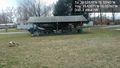
Once back on the main road I snapped a pic of a parking lot that had some cool military vehicles in it.
After this one I decided to head for the Washington, DC East geohash in Cambridge, MD.
Tracklog
Photos

Obligatory silly grin @39.5357,-76.1074
Picnic gazebo @39.5357,-76.1074


