Difference between revisions of "2013-03-29 38 -77"
imported>Mistifi339 m (Undo revision 368580 by Mistifi339 (talk) photos added to wrong graticule page) |
imported>Palmpje m (Cleaning up the New Report category) |
||
| Line 77: | Line 77: | ||
}} | }} | ||
| − | <!-- =============== USEFUL CATEGORIES FOLLOW ================ | + | <!-- =============== USEFUL CATEGORIES FOLLOW ================ --> |
| − | |||
| − | |||
[[Category:Expeditions]] | [[Category:Expeditions]] | ||
| − | |||
[[Category:Expeditions with photos]] | [[Category:Expeditions with photos]] | ||
[[Category:Coordinates reached]] | [[Category:Coordinates reached]] | ||
| − | |||
| − | |||
| − | |||
| − | |||
| − | |||
| − | |||
| − | |||
| − | |||
| − | |||
| − | |||
| − | |||
| − | |||
| − | |||
| − | |||
| − | |||
| − | |||
| − | |||
| − | |||
| − | |||
| − | |||
| − | |||
| − | |||
| − | |||
| − | |||
| − | |||
| − | |||
| − | |||
| − | |||
| − | |||
| − | |||
| − | |||
| − | |||
| − | |||
| − | |||
Revision as of 16:43, 4 June 2013
| Fri 29 Mar 2013 in 38,-77: 38.4570218, -77.7479313 geohashing.info google osm bing/os kml crox |
Location
In the Chester F Phelps Wildlife Management Area in Sumerduck, VA
Participants
- OfficeLinebacker (talk)OfficeLinebacker
- Allison
Plans
I am picking up Allison in Annandale at 2:30pm and going to set out from there. Wish us luck!
Expedition
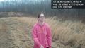
This was the best expedition yet! I picked up Ally and we took back roads to Sumerdick. We had to improvise a bit because many of the roads are blocked off. All the roads into the area are gravel. We found one that was open and then turned off onto a trail that's for horse back riding but is wide enough for a car. We drove on it for about a mile, over hills, through grass, through mud, and even forded a stream. Then we pulled over at the spot that was closest to the geohash.
We had to deal with really tough sticker plants (big thorns) for the first hundred feet before getting to the woods. Once in the woods it was relatively straightforward. We did the GPS dance 650 feet into the woods and found our spot. We had a 4G connection (!) and took the pics and uploaded them right there for proof.
Afterwards, we stopped in the | Sumerdick Trading Company for some drinks. It's pronounced "Summer," not "Sumer" as in the ancient land. I bought a tee shirt.
We wasted some time because traffic on Rt 17 was awful. We shopped at a Wal-Mart and got BURNED Cajeta (Goat's milk caramel sauce) and also shopped at an Aldi. Very European.
We then went back and drove on a few more horse trails for fun and to kill time. Then we headed back, but took 17 N to I-66 because GPS showed that 17 S to I-95 was still congested.
By far the most fun and satisfying geohash expedition to date.
Tracklog
Photos

Made it! @38.4570,-77.7480
Allison returns @38.4569,-77.7457
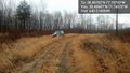
The Steed @38.4570,-77.7457


Achievements
OfficeLinebacker earned the Consecutive geohash achievement
|