Difference between revisions of "2013-03-29 38 -77"
imported>OfficeLinebacker (→Location) |
imported>FippeBot m (Location) |
||
| (18 intermediate revisions by 4 users not shown) | |||
| Line 1: | Line 1: | ||
| − | |||
| − | |||
| − | |||
| − | |||
| − | |||
| − | |||
| − | |||
| − | |||
| − | |||
| − | |||
{{meetup graticule | {{meetup graticule | ||
| lat=38 | | lat=38 | ||
| Line 19: | Line 9: | ||
== Location == | == Location == | ||
<!-- where you've surveyed the hash to be --> | <!-- where you've surveyed the hash to be --> | ||
| − | In the Chester F Phelps Wildlife Management Area in | + | In the [http://www.dgif.virginia.gov/wmas/detail.asp?pid=17 Chester F Phelps Wildlife Management Area] in Sumerduck, VA |
== Participants == | == Participants == | ||
<!-- who attended: If you link to your wiki user name in this section, your expedition will be picked up by the various statistics generated for geohashing. You may use three tildes ~ as a shortcut to automatically insert the user signature of the account you are editing with. | <!-- who attended: If you link to your wiki user name in this section, your expedition will be picked up by the various statistics generated for geohashing. You may use three tildes ~ as a shortcut to automatically insert the user signature of the account you are editing with. | ||
--> | --> | ||
| + | * [[User:OfficeLinebacker|OfficeLinebacker]] ([[User talk:OfficeLinebacker|talk]])OfficeLinebacker | ||
| + | |||
| + | * Allison | ||
== Plans == | == Plans == | ||
<!-- what were the original plans --> | <!-- what were the original plans --> | ||
| + | I am picking up Allison in Annandale at 2:30pm and going to set out from there. Wish us luck! | ||
== Expedition == | == Expedition == | ||
<!-- how it all turned out. your narrative goes here. --> | <!-- how it all turned out. your narrative goes here. --> | ||
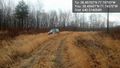
| + | This was the best expedition yet! I picked up Ally and we took back roads to Sumerdick. We had to improvise a bit because many of the roads are blocked off. All the roads into the area are gravel. We found one that was open and then turned off onto a trail that's for horse back riding but is wide enough for a car. We drove on it for about a mile, over hills, through grass, through mud, and even forded a stream. Then we pulled over at the spot that was closest to the geohash. | ||
| + | |||
| + | We had to deal with really tough sticker plants (big thorns) for the first hundred feet before getting to the woods. Once in the woods it was relatively straightforward. We did the GPS dance 650 feet into the woods and found our spot. We had a 4G connection (!) and took the pics and uploaded them right there for proof. | ||
| + | |||
| + | Afterwards, we stopped in the [http://users.erols.com/ducknest/ | Sumerdick Trading Company ] for some drinks. It's pronounced "Summer," not "Sumer" as in the ancient land. I bought a tee shirt. | ||
| + | |||
| + | We wasted some time because traffic on Rt 17 was awful. We shopped at a Wal-Mart and got BURNED Cajeta (Goat's milk caramel sauce) and also shopped at an Aldi. Very European. | ||
| + | |||
| + | We then went back and drove on a few more horse trails for fun and to kill time. Then we headed back, but took 17 N to I-66 because GPS showed that 17 S to I-95 was still congested. | ||
| + | |||
| + | By far the most fun and satisfying geohash expedition to date. | ||
== Tracklog == | == Tracklog == | ||
| Line 39: | Line 44: | ||
--> | --> | ||
<gallery perrow="5"> | <gallery perrow="5"> | ||
| + | |||
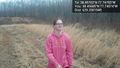
| + | Image:2013-03-29_38_-77_16-38-55-249.jpg | Made it! [http://www.openstreetmap.org/?lat=38.45699682&lon=-77.74795742&zoom=16&layers=B000FTF @38.4570,-77.7480] | ||
| + | |||
| + | Image:2013-03-29_38_-77_16-41-12-079.jpg | [http://www.openstreetmap.org/?lat=38.45701838&lon=-77.74797630&zoom=16&layers=B000FTF @38.4570,-77.7480] | ||
| + | |||
| + | Image:2013-03-29_38_-77_16-42-59-411.jpg | [http://www.openstreetmap.org/?lat=38.45701617&lon=-77.74787452&zoom=16&layers=B000FTF @38.4570,-77.7479] | ||
| + | |||
| + | Image:2013-03-29_38_-77_16-49-03-896.jpg | Allison returns [http://www.openstreetmap.org/?lat=38.45685013&lon=-77.74574478&zoom=16&layers=B000FTF @38.4569,-77.7457] | ||
| + | |||
| + | Image:2013-03-29_38_-77_16-49-22-484.jpg | The Steed [http://www.openstreetmap.org/?lat=38.45697245&lon=-77.74569548&zoom=16&layers=B000FTF @38.4570,-77.7457] | ||
</gallery> | </gallery> | ||
| Line 44: | Line 59: | ||
{{#vardefine:ribbonwidth|800px}} | {{#vardefine:ribbonwidth|800px}} | ||
<!-- Add any achievement ribbons you earned below, or remove this section --> | <!-- Add any achievement ribbons you earned below, or remove this section --> | ||
| + | {{consecutive geohash 2 | ||
| + | | count = 7 | ||
| + | | latitude = 38 | ||
| + | | longitude = -76 | ||
| + | | date = 2013-03-23 | ||
| + | | name = OfficeLinebacker | ||
| + | }} | ||
| − | |||
| − | |||
| − | |||
| − | |||
| − | |||
| − | |||
| − | |||
| − | |||
| − | |||
| − | |||
| − | |||
[[Category:Expeditions]] | [[Category:Expeditions]] | ||
| − | |||
[[Category:Expeditions with photos]] | [[Category:Expeditions with photos]] | ||
| − | |||
| − | |||
| − | |||
| − | |||
| − | |||
[[Category:Coordinates reached]] | [[Category:Coordinates reached]] | ||
| − | + | {{location|US|VA|FQ}} | |
| − | |||
| − | |||
| − | |||
| − | |||
| − | |||
| − | |||
| − | |||
| − | |||
| − | |||
| − | |||
| − | |||
| − | |||
| − | |||
| − | |||
| − | |||
| − | |||
| − | |||
Latest revision as of 01:39, 14 August 2019
| Fri 29 Mar 2013 in 38,-77: 38.4570218, -77.7479313 geohashing.info google osm bing/os kml crox |
Location
In the Chester F Phelps Wildlife Management Area in Sumerduck, VA
Participants
- OfficeLinebacker (talk)OfficeLinebacker
- Allison
Plans
I am picking up Allison in Annandale at 2:30pm and going to set out from there. Wish us luck!
Expedition
This was the best expedition yet! I picked up Ally and we took back roads to Sumerdick. We had to improvise a bit because many of the roads are blocked off. All the roads into the area are gravel. We found one that was open and then turned off onto a trail that's for horse back riding but is wide enough for a car. We drove on it for about a mile, over hills, through grass, through mud, and even forded a stream. Then we pulled over at the spot that was closest to the geohash.
We had to deal with really tough sticker plants (big thorns) for the first hundred feet before getting to the woods. Once in the woods it was relatively straightforward. We did the GPS dance 650 feet into the woods and found our spot. We had a 4G connection (!) and took the pics and uploaded them right there for proof.
Afterwards, we stopped in the | Sumerdick Trading Company for some drinks. It's pronounced "Summer," not "Sumer" as in the ancient land. I bought a tee shirt.
We wasted some time because traffic on Rt 17 was awful. We shopped at a Wal-Mart and got BURNED Cajeta (Goat's milk caramel sauce) and also shopped at an Aldi. Very European.
We then went back and drove on a few more horse trails for fun and to kill time. Then we headed back, but took 17 N to I-66 because GPS showed that 17 S to I-95 was still congested.
By far the most fun and satisfying geohash expedition to date.
Tracklog
Photos

Made it! @38.4570,-77.7480
Allison returns @38.4569,-77.7457
The Steed @38.4570,-77.7457


Achievements
OfficeLinebacker earned the Consecutive geohash achievement
|