Difference between revisions of "2013-03-29 41 -73"
imported>Mistifi339 m (→Photos) |
imported>FippeBot m (Location) |
||
| (5 intermediate revisions by 3 users not shown) | |||
| Line 1: | Line 1: | ||
| − | |||
| − | |||
| − | |||
| − | |||
| − | |||
| − | |||
| − | |||
| − | |||
| − | |||
| − | |||
{{meetup graticule | {{meetup graticule | ||
| lat=41 | | lat=41 | ||
| Line 55: | Line 45: | ||
--> | --> | ||
<gallery perrow="5"> | <gallery perrow="5"> | ||
| − | |||
| − | + | <gallery perrow="5"> | |
| + | |||
| + | Image:41-73_2013_03_29warning2.jpg | Dire Warnings | ||
| + | |||
| + | Image: 41-73 2013 03 29warning1.jpg | More warnings | ||
| + | |||
| + | Image: 41-73 2013 03 29boatyard.jpg | Where boats go to die | ||
| + | |||
| + | Image: 41-73 2013 03 29reservoirview.jpg | ||
| + | |||
| + | Image:41-73 2013 03 29chainedboat.jpg | Poor Boat | ||
| + | |||
| + | Image: 41-73 2013 03 29gps.jpg | Not the best proof | ||
| + | |||
| + | Image: 41-73 2013 03 29mark.jpg | The marker | ||
| + | |||
| + | Image: 41-73 2013 03 29portrait.jpg | My picnic and me | ||
| + | |||
| + | |||
| + | |||
</gallery> | </gallery> | ||
| Line 65: | Line 73: | ||
| − | |||
| − | |||
| − | |||
| − | |||
| − | |||
| − | |||
| − | |||
| − | |||
| − | |||
| − | |||
[[Category:Expeditions]] | [[Category:Expeditions]] | ||
| − | |||
[[Category:Expeditions with photos]] | [[Category:Expeditions with photos]] | ||
| − | |||
| − | |||
| − | |||
| − | |||
[[Category:Coordinates reached]] | [[Category:Coordinates reached]] | ||
| − | + | {{location|US|NY|PU}} | |
| − | |||
| − | |||
| − | |||
| − | |||
| − | |||
| − | |||
| − | |||
| − | |||
| − | |||
| − | |||
| − | |||
| − | |||
| − | |||
| − | |||
| − | |||
| − | |||
| − | |||
Latest revision as of 05:43, 6 August 2019
| Fri 29 Mar 2013 in 41,-73: 41.4570218, -73.7479313 geohashing.info google osm bing/os kml crox |
Location
41.457021°, -73.747932°
Hash found on a twisty, windy reservoir-hugging road in Carmel, NY
Participants
Plans
This was my first Geohash and I knew it would be tricky since I didn't have a hand-held GPS unit. I have a GPS in my car which can take coordinates but which has been misbehaving in the sense that the minute you remove it from the power source (ie: the car) it has about 30 seconds before it powers down.
I spent the morning considering how close the hash might be to the road based on the maps and satellite images and then decided to go ahead anyway. I packed some snacks and juice and a mat to sit on and took to the road.
Expedition
Not bad for my first geohashing experience!
The drive to the location was relatively uneventful except for the fact that my gps took me on every back road between Stamford and Carmel. I'm pretty sure I could have made it to the location in 40 minutes, but taking the back roads, the journey took about 1.25 hrs. I also missed a turn as I got much closer to the hash and the gps forced me to reroute around the entire reservoir.
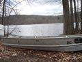
There was a good place to park about 1/5 of a mile away near a local boat launch. The maps indicated a lot more sandy space. Either the tide was in, or ice and snow melt have increased the reservoir levels. either way, the hash was pretty much just before the waterline.
After walking down the road, houses up the hill on my left, a short strip of forest before the reservoir shore on my right, I passed a number of dire warnings about recreational use of the space and trespassing. I ignored these and crossed over a stone wall and down through the leaf litter.
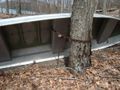
If you've ever wondered what boat owners do with their vessels during the winter months, I now have an answer. They chain the poor things up. I found something akin to a boat internment camp, no less than 15 boats (probably more like 25) beached and tied to trees in the forest. How odd! Someone on the opposite bank had a particularly proud rooster.
I spread out my blanket and had my snack of cheese, crackers, and capri sun and took in the reservoir. I left a mark on a tree chained to a truly depressed boat. I explored the area a little bit more and found a watch in a tree and a few other oddities. Someone around there has a sense of humor. Then it was time to clean up and head back home.
Tracklog
Photos
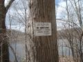
Dire Warnings
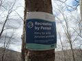
More warnings
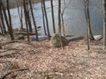
Where boats go to die
Poor Boat
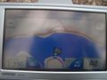
Not the best proof
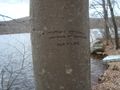
The marker
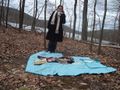
My picnic and me


