Difference between revisions of "2013-03-29 47 8"
imported>Calamus (Postponing) |
m (per Renaming Proposal) |
||
| (4 intermediate revisions by 2 users not shown) | |||
| Line 1: | Line 1: | ||
| − | + | [[Image:{{{image|2013-03-29 47 8 kyburg.jpg}}}|thumb|left]] | |
| − | |||
| − | |||
| − | [[Image:{{{image| | ||
| − | |||
| − | |||
| − | |||
| − | |||
| − | |||
| − | |||
{{meetup graticule | {{meetup graticule | ||
| lat=47 | | lat=47 | ||
| Line 14: | Line 5: | ||
| date=2013-03-29 | | date=2013-03-29 | ||
}} | }} | ||
| − | |||
| − | |||
__NOTOC__ | __NOTOC__ | ||
== Location == | == Location == | ||
| Line 24: | Line 13: | ||
== Plans == | == Plans == | ||
| − | S3 Train to Effretikon leaving Zurich at 3.03pm on rail 43/44, then bus #655 to be at the municipial house at | + | S3 Train to Effretikon leaving Zurich at 3.03pm on rail 43/44, then bus #655 to be at the municipial house at 3.43. Then into the woods. |
== Expedition == | == Expedition == | ||
| − | + | The branch broke off and for a moment Calamus was hurtling into the abyss below, before he blindly caught a stable root with his left hand. As he was hanging over the river gorge, trying not to look down, but doing it anyway, a voice he hadn't heard for some time popped up in his head. "You really suck at history, right?", Gertrud Schmidlin-Habermacher jibed. "Count Liutfried of Winterthur searched his whole vast lands for an impenetrable place to build his fortress, and his architects with their advanced 1000 AD technology chose this very hill. And now you actually think ''you'' could climb up to it? An untrained bookworm?" "Thanks, Gertie, that's really helpful. Couldn't you have warned me?" "Where's the fun in that? Besides, you need to learn at last that height maps are vital to the decision whether an expedition should be started." "I ''did'' check it, and it looked fine!" "So learn how to interpret those bloody lines correctly. Anyway, I'm off to the knitting group. You can join us if you die. And if you know your patterns; I'm not going to tutor you." For being a Patron of Geohashing, Gertrud was rather unhelpful sometimes. | |
| + | |||
| + | Yet, everything had started so well. Calamus had arrived at snowy Kyburg village without a problem, and, next to the castle, had found a path taking him into the forest below. The path had ended abruptly in the middle of nowhere, but it would just be getting over the ''Brüelbach'' (or "crying brook"), a tributary of the Töss, and then some homing. He'd thought. | ||
| + | The Brüelbach had turned out to have developed quite a gorge in the course of its existence, so getting over it had proven harder than anticipated. Especially since the other side was a steep clay slope of about a hundred metres in height, very slippery due to the continuous rain and snowfall, and almost bare of any firm vegetation to hold on to, except for the roots, from one of which Calamus was now dangling. | ||
| + | |||
| + | It had been a rather stupid idea to come here, he thought while pulling himself up again, and decided to try and make it back to civilisation rather than break his neck during further persuit of the hashpoint. But even that meant getting up that never-ending slick slope. | ||
| + | |||
| + | It took Calamus about forty minutes to climb out of the gorge. When he finally emerged, he tumbled straight into the tavern. At first, he was afraid he would be sent away, dirty and sweaty and everything as he was, but the innkeeper just looked at him with big eyes, drew him a large beer and said "That one's on me, lad". | ||
| + | |||
| + | This was clearly a failure, but it might have taught Calamus a thing or two about height maps. | ||
== Tracklog == | == Tracklog == | ||
| − | + | [http://www.everytrail.com/view_trip.php?trip_id=2066749 On EveryTrail] | |
== Photos == | == Photos == | ||
| − | + | No pictures of the gorge. I was kind of busy not breaking anything. | |
| − | |||
| − | |||
<gallery perrow="5"> | <gallery perrow="5"> | ||
| + | Image:2013-03-29 47 8 kyburg.jpg | The Kyburg | ||
| + | Image:2013-03-29 47 8 down.jpg | Going down | ||
| + | Image:2013-03-29 47 8 sun.jpg | The sun hides | ||
| + | Image:2013-03-29 47 8 emerging.jpg | Emerging | ||
</gallery> | </gallery> | ||
== Achievements == | == Achievements == | ||
| + | I think I'll take that MNB now. After all, several parts of my body still hurt. | ||
{{#vardefine:ribbonwidth|800px}} | {{#vardefine:ribbonwidth|800px}} | ||
| − | + | {{done with nature | latitude = 47 | longitude = 8 | date = 2013-03-29 | name = [[User:Calamus|Calamus]]}} | |
| − | + | {{Cliffs of Despair | latitude = 47 | longitude = 8 | date = 2013-03-29 | name = [[User:Calamus|Calamus]] | terrain = 100 height metres of slick earth}} | |
| − | |||
| − | |||
[[Category:Expeditions]] | [[Category:Expeditions]] | ||
| − | |||
[[Category:Expeditions with photos]] | [[Category:Expeditions with photos]] | ||
| − | |||
| − | |||
| − | |||
| − | |||
| − | |||
| − | |||
| − | |||
| − | |||
| − | |||
[[Category:Coordinates not reached]] | [[Category:Coordinates not reached]] | ||
| − | |||
| − | |||
[[Category:Not reached - Mother Nature]] | [[Category:Not reached - Mother Nature]] | ||
| − | + | {{location|CH|ZH}} | |
| − | |||
| − | |||
| − | |||
| − | |||
| − | |||
| − | |||
| − | |||
| − | |||
| − | |||
| − | |||
Latest revision as of 14:34, 2 April 2024

| Fri 29 Mar 2013 in 47,8: 47.4570218, 8.7479313 geohashing.info google osm bing/os kml crox |
Location
A forest near Kyburg.
Participants
Plans
S3 Train to Effretikon leaving Zurich at 3.03pm on rail 43/44, then bus #655 to be at the municipial house at 3.43. Then into the woods.
Expedition
The branch broke off and for a moment Calamus was hurtling into the abyss below, before he blindly caught a stable root with his left hand. As he was hanging over the river gorge, trying not to look down, but doing it anyway, a voice he hadn't heard for some time popped up in his head. "You really suck at history, right?", Gertrud Schmidlin-Habermacher jibed. "Count Liutfried of Winterthur searched his whole vast lands for an impenetrable place to build his fortress, and his architects with their advanced 1000 AD technology chose this very hill. And now you actually think you could climb up to it? An untrained bookworm?" "Thanks, Gertie, that's really helpful. Couldn't you have warned me?" "Where's the fun in that? Besides, you need to learn at last that height maps are vital to the decision whether an expedition should be started." "I did check it, and it looked fine!" "So learn how to interpret those bloody lines correctly. Anyway, I'm off to the knitting group. You can join us if you die. And if you know your patterns; I'm not going to tutor you." For being a Patron of Geohashing, Gertrud was rather unhelpful sometimes.
Yet, everything had started so well. Calamus had arrived at snowy Kyburg village without a problem, and, next to the castle, had found a path taking him into the forest below. The path had ended abruptly in the middle of nowhere, but it would just be getting over the Brüelbach (or "crying brook"), a tributary of the Töss, and then some homing. He'd thought. The Brüelbach had turned out to have developed quite a gorge in the course of its existence, so getting over it had proven harder than anticipated. Especially since the other side was a steep clay slope of about a hundred metres in height, very slippery due to the continuous rain and snowfall, and almost bare of any firm vegetation to hold on to, except for the roots, from one of which Calamus was now dangling.
It had been a rather stupid idea to come here, he thought while pulling himself up again, and decided to try and make it back to civilisation rather than break his neck during further persuit of the hashpoint. But even that meant getting up that never-ending slick slope.
It took Calamus about forty minutes to climb out of the gorge. When he finally emerged, he tumbled straight into the tavern. At first, he was afraid he would be sent away, dirty and sweaty and everything as he was, but the innkeeper just looked at him with big eyes, drew him a large beer and said "That one's on me, lad".
This was clearly a failure, but it might have taught Calamus a thing or two about height maps.
Tracklog
Photos
No pictures of the gorge. I was kind of busy not breaking anything.
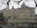
The Kyburg
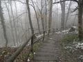
Going down
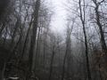
The sun hides
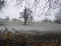
Emerging


Achievements
I think I'll take that MNB now. After all, several parts of my body still hurt.
Calamus earned the Done with Nature consolation prize
|
Calamus earned the Cliffs of Despair consolation prize
|