Difference between revisions of "2013-04-02 47 -122"
From Geohashing
imported>Thomcat ([live picture] [http://www.openstreetmap.org/?lat=47.71836495&lon=-122.01652469&zoom=16&layers=B000FTF @47.7184,-122.0165]) |
imported>Thomcat ([live picture] Tolt pipeline trail SE facing [http://www.openstreetmap.org/?lat=47.71982661&lon=-122.01655076&zoom=16&layers=B000FTF @47.7198,-122.0166]) |
||
| Line 36: | Line 36: | ||
Image:2013-04-02_47_-122_16-09-32-733.jpg | [http://www.openstreetmap.org/?lat=47.71836495&lon=-122.01652469&zoom=16&layers=B000FTF @47.7184,-122.0165] | Image:2013-04-02_47_-122_16-09-32-733.jpg | [http://www.openstreetmap.org/?lat=47.71836495&lon=-122.01652469&zoom=16&layers=B000FTF @47.7184,-122.0165] | ||
| + | |||
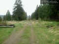
| + | Image:2013-04-02_47_-122_16-11-25-127.jpg | Tolt pipeline trail SE facing [http://www.openstreetmap.org/?lat=47.71982661&lon=-122.01655076&zoom=16&layers=B000FTF @47.7198,-122.0166] | ||
</gallery> | </gallery> | ||
Revision as of 23:11, 2 April 2013
| Tue 2 Apr 2013 in Seattle: 47.7180351, -122.0166102 geohashing.info google osm bing/os kml crox |
Location
Off 242nd Ave in Redmond, near the top of the bluff overlooking Duvall. Just south of the Tolt Pipeline Trail.
Participants
Plans
Stop by after work, roughly 4:30.
Expedition
- On my way - eta 4:10 pm -- Thomcat (talk) @47.7618,-122.1316 15:43, 2 April 2013 (PDT)
- Here we are! -- Thomcat (talk) @47.7180,-122.0166 16:04, 2 April 2013 (PDT)
Tracklog
Photos

On the spot @47.7180,-122.0166
Tolt pipeline trail SE facing @47.7198,-122.0166


Achievements