Difference between revisions of "2013-04-02 56 -2"
imported>Shane |
imported>FippeBot m (Location) |
||
| (3 intermediate revisions by 2 users not shown) | |||
| Line 1: | Line 1: | ||
| − | |||
| − | |||
| − | |||
| − | |||
{{meetup graticule | {{meetup graticule | ||
| lat=56 | | lat=56 | ||
| Line 29: | Line 25: | ||
== Photos == | == Photos == | ||
<!-- Insert pictures between the gallery tags using the following format: | <!-- Insert pictures between the gallery tags using the following format: | ||
| − | Image:2012-##-## ## ## Alpha.jpg | Witty Comment | + | Image:2012-##-## ## ## Alpha.jpg | Witty Comment --> |
<gallery perrow="6"> | <gallery perrow="6"> | ||
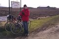
| − | Image: | + | Image:2013-04-02_56_-2_farm.jpg | Composting Forbidden |
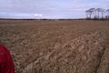
| − | </gallery | + | Image:2013-04-02_56_-2_viewfrom.jpg | Don't look back in anger |
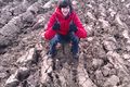
| + | Image:2013-04-02_56_-2_pebble.jpg | XKCD marks the spot | ||
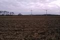
| + | Image:2013-04-02_56_-2_thelaw.jpg | The Law | ||
| + | </gallery> | ||
== Achievements == | == Achievements == | ||
| − | + | {{Multihash | |
| − | [[Category:Expeditions with photos]] | + | | latitude1 = 56 |
| + | | longitude1 = -2 | ||
| + | | latitude2 = 56 | ||
| + | | longitude2 = -3 | ||
| + | | date = 2013-04-02 | ||
| + | | name = Shane and Bryn | ||
| + | | image = 2013-04-02_56_-3_bagged.jpg | ||
| + | }} | ||
| + | |||
| + | [[Category:Expeditions with photos]] | ||
[[Category:Coordinates reached]] | [[Category:Coordinates reached]] | ||
[[Category:Expeditions]] | [[Category:Expeditions]] | ||
| + | {{location|GB|SCT|ELN}} | ||
Latest revision as of 05:44, 6 August 2019
| Tue 2 Apr 2013 in 56,-2: 56.0297718, -2.7718663 geohashing.info google osm bing/os kml crox |
Location
A field near Dirleton
Participants
Plans
Shane and Bryn are attempting a double-hash by cycling from North Berwick station via 2013-04-02 56 -2 and 2013-04-02 56 -3 to Larbert Station.
Expedition
We got the train to North Berwick exactly as planned, and found our way to the first location without incident. The field was recently ploughed but a dry surface made it very easy to walk on, and we were confident we were not damaging a crop. The location was marked with a pebble, presumably dropped from orbit by a GPS satellite (a service not widely advertised).
We then cycled off in the general direction of Edinburgh with the wind behind us. Lunch was at the harbour cafe in Musselburgh before we joined the North Edinburgh cycle network heading for our second geohash of the day...
Photos
Composting Forbidden
Don't look back in anger
XKCD marks the spot
The Law


Achievements
Shane and Bryn earned the Multihash Achievement
|