Difference between revisions of "2013-04-05 38 -78"
imported>OfficeLinebacker (→Location) |
imported>FippeBot m (Location) |
||
| (10 intermediate revisions by 2 users not shown) | |||
| Line 15: | Line 15: | ||
}} | }} | ||
| − | + | ||
__NOTOC__ | __NOTOC__ | ||
== Location == | == Location == | ||
| − | + | ||
On rough, hilly ground near Syria, VA | On rough, hilly ground near Syria, VA | ||
== Participants == | == Participants == | ||
| − | + | ||
| − | + | * [[User:OfficeLinebacker|OfficeLinebacker]] | |
| + | * Allison | ||
== Plans == | == Plans == | ||
| − | + | ||
| + | The plan was to pick Allison up in Annandale at 2:40 and head straight out of town, beating traffic. | ||
| + | |||
| + | This plan did not work--traffic starts EARLY outside of DC on Fridays. | ||
== Expedition == | == Expedition == | ||
| − | |||
| − | + | We encountered already heavy traffic before 3 pm, unfortunately. But we persevered. We lost cell phone signal completely about halfway there, just past Warrenton and near Washington, VA. | |
| + | |||
| + | Once we arrived we went to the point on the public road that was nearest to the spot, about 2000 feet, and the terrain was extremely hard--steep dropoff to a creek, then a steep climb on the other side. The satellite view indicated that it was all uncut forest but we had seen driveways so we decided to double back. | ||
| + | |||
| + | We drove on driveways and onto what we thought was private property but no signs specifically. We took a rough farm track but it took us farther away from the objective. | ||
| + | |||
| + | Finally we approached a beautiful, just-built house at the top of a very steep hill and it was too obvious so we went to the house to ask permission. The guy came out and we had a nice chat about the area and he gave us permission. We drove on a very rough, narrow track to within about 400 feet of the point, knocking down saplings and such. We got out of the car and did the GPS dance up the hill. See, we didn't have data so there was no map on the app, just a blue point and a chequered flag on a grey tile background. | ||
| + | |||
| + | Finally after zig zagging up the mountain we got within 15 feet of the point. Success. Took a few pics, then back down the mountain. | ||
| + | |||
| + | Upon driving away we started to hear a grinding noise under the car on acceleration. I figured it was a tree branch stuck under there that would wear/break away. Finally after checking the wheel areas on a couple of stops, we parked at a Wawa for a hoagie and cheap gas and I crawled under the car to see what was going on. It was the driveshaft loop, bent into the driveshaft from a particularly gnarly bump. I bent it back away from the driveshaft with my bare hands. Off we went and no more noise. | ||
| + | |||
== Tracklog == | == Tracklog == | ||
<!-- if your GPS device keeps a log, you may post a link here --> | <!-- if your GPS device keeps a log, you may post a link here --> | ||
| Line 42: | Line 56: | ||
<gallery perrow="5"> | <gallery perrow="5"> | ||
| + | Image:2013_04_05_RockPose.jpg | Master of the geohash! | ||
Image:2013-04-05_38_-78_14-55-26-347.jpg | [http://www.openstreetmap.org/?lat=38.88150190&lon=-77.23468920&zoom=16&layers=B000FTF @38.8815,-77.2347] | Image:2013-04-05_38_-78_14-55-26-347.jpg | [http://www.openstreetmap.org/?lat=38.88150190&lon=-77.23468920&zoom=16&layers=B000FTF @38.8815,-77.2347] | ||
| − | |||
Image:2013-04-05_38_-78_20-17-49-134.jpg | [http://www.openstreetmap.org/?lat=38.73438138&lon=-77.77081167&zoom=16&layers=B000FTF @38.7344,-77.7708] | Image:2013-04-05_38_-78_20-17-49-134.jpg | [http://www.openstreetmap.org/?lat=38.73438138&lon=-77.77081167&zoom=16&layers=B000FTF @38.7344,-77.7708] | ||
| + | Image:2013-04-05_38_-78_10-08-19-043.jpg | Cool tree with mushrooms | ||
| + | Image:2013-04-05_38_-78_10-08-37-226.jpg | The car | ||
| + | Image:2013_04_05_Proof2.jpg | Proof! | ||
| + | Image:2013_04_05_Horses.jpg | Stopped to pet some horses on the way home | ||
</gallery> | </gallery> | ||
== Achievements == | == Achievements == | ||
{{#vardefine:ribbonwidth|800px}} | {{#vardefine:ribbonwidth|800px}} | ||
| − | |||
| + | {{Ambassador geohash | ||
| + | | latitude = 38 | ||
| + | | longitude = -78 | ||
| + | | date = 2013-04-05 | ||
| + | | granter = British Property Owner | ||
| + | | name = OfficeLinebacker | ||
| + | }} | ||
| − | + | * Land Geohash | |
| − | |||
| − | |||
| − | |||
| − | |||
| − | |||
| − | |||
| − | |||
[[Category:Expeditions]] | [[Category:Expeditions]] | ||
| − | + | ||
[[Category:Expeditions with photos]] | [[Category:Expeditions with photos]] | ||
| − | |||
| − | |||
| − | |||
| − | |||
| − | |||
[[Category:Coordinates reached]] | [[Category:Coordinates reached]] | ||
| − | + | {{location|US|VA|MD}} | |
| − | |||
| − | |||
| − | |||
| − | |||
| − | |||
| − | |||
| − | |||
| − | |||
| − | |||
| − | |||
| − | |||
| − | |||
| − | |||
| − | |||
| − | |||
| − | |||
| − | |||
Latest revision as of 05:46, 6 August 2019
| Fri 5 Apr 2013 in 38,-78: 38.4922403, -78.3755388 geohashing.info google osm bing/os kml crox |
Location
On rough, hilly ground near Syria, VA
Participants
- OfficeLinebacker
- Allison
Plans
The plan was to pick Allison up in Annandale at 2:40 and head straight out of town, beating traffic.
This plan did not work--traffic starts EARLY outside of DC on Fridays.
Expedition
We encountered already heavy traffic before 3 pm, unfortunately. But we persevered. We lost cell phone signal completely about halfway there, just past Warrenton and near Washington, VA.
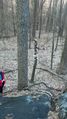
Once we arrived we went to the point on the public road that was nearest to the spot, about 2000 feet, and the terrain was extremely hard--steep dropoff to a creek, then a steep climb on the other side. The satellite view indicated that it was all uncut forest but we had seen driveways so we decided to double back.
We drove on driveways and onto what we thought was private property but no signs specifically. We took a rough farm track but it took us farther away from the objective.
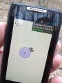
Finally we approached a beautiful, just-built house at the top of a very steep hill and it was too obvious so we went to the house to ask permission. The guy came out and we had a nice chat about the area and he gave us permission. We drove on a very rough, narrow track to within about 400 feet of the point, knocking down saplings and such. We got out of the car and did the GPS dance up the hill. See, we didn't have data so there was no map on the app, just a blue point and a chequered flag on a grey tile background.
Finally after zig zagging up the mountain we got within 15 feet of the point. Success. Took a few pics, then back down the mountain.
Upon driving away we started to hear a grinding noise under the car on acceleration. I figured it was a tree branch stuck under there that would wear/break away. Finally after checking the wheel areas on a couple of stops, we parked at a Wawa for a hoagie and cheap gas and I crawled under the car to see what was going on. It was the driveshaft loop, bent into the driveshaft from a particularly gnarly bump. I bent it back away from the driveshaft with my bare hands. Off we went and no more noise.
Tracklog
Photos
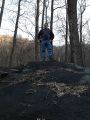
Master of the geohash!
Cool tree with mushrooms
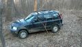
The car
Proof!
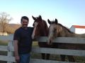
Stopped to pet some horses on the way home


Achievements
OfficeLinebacker earned the Ambassador achievement
|
- Land Geohash