Difference between revisions of "2013-04-14 42 -90"
imported>Swensonj (→Participants) |
imported>FippeBot m (Location) |
||
| (15 intermediate revisions by 2 users not shown) | |||
| Line 24: | Line 24: | ||
== Plans == | == Plans == | ||
| − | + | After waiting for months for a really accessible hash to show up, I ([[User:Swensonj|SwensonJ]]) find one on a day when I have to go to Illinois for a [http://en.wikipedia.org/wiki/Pinewood_derby pinewood derby] race. | |
| + | |||
| + | Luckily, family members have to be at an event in Dubuque at the same time. I believe I've prevailed on them to [[Puppet Master Geohash|visit the hash for me]].... | ||
== Expedition == | == Expedition == | ||
<!-- how it all turned out. your narrative goes here. --> | <!-- how it all turned out. your narrative goes here. --> | ||
| − | == | + | === SwensonJ === |
| − | + | My son and I, and our friends, had an excellent trip to the pinewood derby. We got home well before my wife and daughter, and had to wait anxiously to see if the gymnastics and the geohash had gone well -- my wife didn't take her cell phone along. | |
| + | |||
| + | Eventually they came home, healthy and happy, to report a successful hash. | ||
| + | |||
| + | === SwensonJ's wife === | ||
| + | The gymnastics went well (daughter bagged a second place trophy), and as quickly as could be expected with 65 contestants under the age of 9. We headed straight for the hash point, which was on the side of a major highway through Dubuque, IA. We decided that we didn't want to park on the side of the highway, so went in search of a better place to park. We could see a subdivision there, but it was new enough to not be on the GPS. Luckily, it was easy to find, and we soon chose a quiet cul-de-sac to park in. I knew that there was a fence all the way along the highway, and so was worried that we'd end up having to park on the road after all, but we found a nice place to go under the fence by a creek. It was pretty muddy, but there were handy branches and roots to step on, and we had grubby shoes on just in case (although I was still in my dress clothes-- we'll plan better next time!). It was a fairly easy walk once we got out of the rosebushes by the creek. Someone had obviously cut down all the brush fairly recently, so we only had to watch out for the occasional stump or marshy patch. As we got close the the hash I thought we'd have to go back under the fence, but luckily remembered to double check. The hash was a little way up the hill to the highway. We had to do only a little dance to get the proof picture, then took a few goofy grin pictures and headed back. Going back under the fence was a little more tricky than the first time, since there weren't any handy branches on the other side, but we only got a little muddy. We headed to Culvers for a celebratory custard, and then started home. On the way we passed a flock of pelicans in a backwater pond on the Mississippi and stopped to take about a million photos. Daughter was very impressed by the way the pelicans all dipped at the same time as they swam around. Actually, I was too, as I had read about it, but had never actually seen it. We got home about 30 minutes later (seeing a bald eagle and 6 turkeys on the way) to find our guys anxiously awaiting us. | ||
== Photos == | == Photos == | ||
| − | |||
| − | |||
| − | |||
<gallery perrow="5"> | <gallery perrow="5"> | ||
| + | Image:2013-04-14_42_-90 Trophy.jpg | Leaving from a successful gymnastics meet. | ||
| + | Image:2013-04-14 42 -90 Blocked.jpg | Thinking about climbing the fence | ||
| + | Image:2013-04-14 42 -90 Access.jpg | This way looks better! | ||
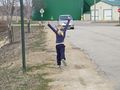
| + | Image:2013-04-14 42 -90 KidUnder.jpg | Daughter goes under fence | ||
| + | Image:2013-04-14 42 -90 MomUnder.jpg | SwensonJ's wife goes under fence | ||
| + | Image:2013-04-14 42 -90 Proof.jpg | We did it! | ||
| + | Image:2013-04-14 42 -90 Grin.jpg | Goofy grins at the hash | ||
| + | Image:2013-04-14 42 -90 Creek.jpg | The creek by the hash | ||
| + | Image:2013-04-14 42 -90 Road.jpg | Up the embankment to the road | ||
| + | Image:2013-04-14 42 -90 Flock.jpg | A flock of pelicans on Mississippi backwaters | ||
| + | Image:2013-04-14 42 -90 Alone.jpg | Pelican! | ||
| + | Image:2013-04-14 42 -90 Spread.jpg | Pelican, with wings spread, joins the flock. | ||
| + | Image:2013-04-14 42 -90 Landing.jpg | Pelicans coming in for a landing. | ||
| + | Image:2013-04-14 42 -90 Gull.jpg | There were also seagulls... | ||
| + | Image:2013-04-14 42 -90 Egret.jpg | ...and egrets... | ||
| + | Image:2013-04-14 42 -90 Heron.jpg | ...and herons... | ||
| + | Image:2013-04-14 42 -90 Hen.jpg | ...and a chicken?!? | ||
| + | Image:2013-04-14 42 -90 Flying.jpg | Flying/dancing back to the van. | ||
| + | Image:2013-04-14 42 -90 Boys.jpg | coming soon: SwensonJ and son at pinewood derby | ||
| + | Image:2013-04-14 42 -90 Race.jpg | coming soon: SwensonJ and son at pinewood derby | ||
</gallery> | </gallery> | ||
| Line 42: | Line 66: | ||
{{#vardefine:ribbonwidth|800px}} | {{#vardefine:ribbonwidth|800px}} | ||
<!-- Add any achievement ribbons you earned below, or remove this section --> | <!-- Add any achievement ribbons you earned below, or remove this section --> | ||
| + | {{Puppet Master Geohash | ||
| + | | latitude = 42 | ||
| + | | longitude = -90 | ||
| + | | date = 2013-04-14 | ||
| + | | puppet = his wife and daughter | ||
| + | | name = [[User:Swensonj|SwensonJ]] | ||
| + | | image = 2014-04-14_42_-90 Grin.jpg | ||
| + | }} | ||
| − | |||
| − | |||
| − | |||
| − | |||
| − | |||
| − | |||
| − | |||
| − | |||
| − | |||
| − | |||
| − | |||
[[Category:Expeditions]] | [[Category:Expeditions]] | ||
| − | |||
[[Category:Expeditions with photos]] | [[Category:Expeditions with photos]] | ||
| − | |||
| − | |||
| − | |||
| − | |||
| − | |||
[[Category:Coordinates reached]] | [[Category:Coordinates reached]] | ||
| − | + | {{location|US|IA|DU}} | |
| − | |||
| − | |||
| − | |||
| − | |||
| − | |||
| − | |||
| − | |||
| − | |||
| − | |||
| − | |||
| − | |||
| − | |||
| − | |||
| − | |||
| − | |||
| − | |||
| − | |||
Latest revision as of 01:52, 14 August 2019
| Sun 14 Apr 2013 in 42,-90: 42.5239406, -90.7271735 geohashing.info google osm bing/os kml crox |
Location
Along NW Arterial near John F. Kennedy Road, Dubuque, Iowa.
Participants
The attractive and gracious wife and daughter of Swensonj (talk).
Plans
After waiting for months for a really accessible hash to show up, I (SwensonJ) find one on a day when I have to go to Illinois for a pinewood derby race.
Luckily, family members have to be at an event in Dubuque at the same time. I believe I've prevailed on them to visit the hash for me....
Expedition
SwensonJ
My son and I, and our friends, had an excellent trip to the pinewood derby. We got home well before my wife and daughter, and had to wait anxiously to see if the gymnastics and the geohash had gone well -- my wife didn't take her cell phone along.
Eventually they came home, healthy and happy, to report a successful hash.
SwensonJ's wife
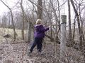
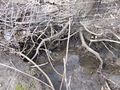
The gymnastics went well (daughter bagged a second place trophy), and as quickly as could be expected with 65 contestants under the age of 9. We headed straight for the hash point, which was on the side of a major highway through Dubuque, IA. We decided that we didn't want to park on the side of the highway, so went in search of a better place to park. We could see a subdivision there, but it was new enough to not be on the GPS. Luckily, it was easy to find, and we soon chose a quiet cul-de-sac to park in. I knew that there was a fence all the way along the highway, and so was worried that we'd end up having to park on the road after all, but we found a nice place to go under the fence by a creek. It was pretty muddy, but there were handy branches and roots to step on, and we had grubby shoes on just in case (although I was still in my dress clothes-- we'll plan better next time!). It was a fairly easy walk once we got out of the rosebushes by the creek. Someone had obviously cut down all the brush fairly recently, so we only had to watch out for the occasional stump or marshy patch. As we got close the the hash I thought we'd have to go back under the fence, but luckily remembered to double check. The hash was a little way up the hill to the highway. We had to do only a little dance to get the proof picture, then took a few goofy grin pictures and headed back. Going back under the fence was a little more tricky than the first time, since there weren't any handy branches on the other side, but we only got a little muddy. We headed to Culvers for a celebratory custard, and then started home. On the way we passed a flock of pelicans in a backwater pond on the Mississippi and stopped to take about a million photos. Daughter was very impressed by the way the pelicans all dipped at the same time as they swam around. Actually, I was too, as I had read about it, but had never actually seen it. We got home about 30 minutes later (seeing a bald eagle and 6 turkeys on the way) to find our guys anxiously awaiting us.
Photos
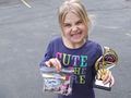
Leaving from a successful gymnastics meet.
Thinking about climbing the fence
This way looks better!
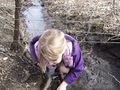
Daughter goes under fence
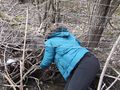
SwensonJ's wife goes under fence
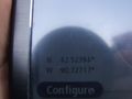
We did it!
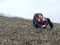
Goofy grins at the hash
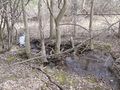
The creek by the hash
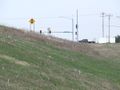
Up the embankment to the road
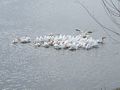
A flock of pelicans on Mississippi backwaters
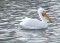
Pelican!
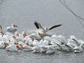
Pelican, with wings spread, joins the flock.
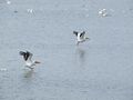
Pelicans coming in for a landing.
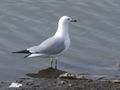
There were also seagulls...
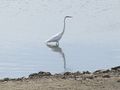
...and egrets...
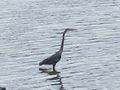
...and herons...
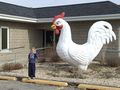
...and a chicken?!?
Flying/dancing back to the van.

coming soon: SwensonJ and son at pinewood derby

coming soon: SwensonJ and son at pinewood derby


Achievements
SwensonJ earned the Puppet Master Geohash achievement
|