Difference between revisions of "2013-04-21 55 37"
From Geohashing
imported>Vb (→Tracklog) |
imported>FippeBot m (Location) |
||
| (4 intermediate revisions by one other user not shown) | |||
| Line 1: | Line 1: | ||
| − | |||
| − | |||
| − | |||
| − | |||
| − | |||
| − | |||
| − | |||
| − | |||
| − | |||
| − | |||
{{meetup graticule | {{meetup graticule | ||
| lat=55 | | lat=55 | ||
| Line 19: | Line 9: | ||
== Location == | == Location == | ||
<!-- where you've surveyed the hash to be --> | <!-- where you've surveyed the hash to be --> | ||
| − | In Choboty forest, Novo-Peredelkino district. | + | In Choboty forest, Novo-Peredelkino district. Which is actually, despite being called a forest, is more like a park. |
== Participants == | == Participants == | ||
<!-- who attended: If you link to your wiki user name in this section, your expedition will be picked up by the various statistics generated for geohashing. You may use three tildes ~ as a shortcut to automatically insert the user signature of the account you are editing with. | <!-- who attended: If you link to your wiki user name in this section, your expedition will be picked up by the various statistics generated for geohashing. You may use three tildes ~ as a shortcut to automatically insert the user signature of the account you are editing with. | ||
--> | --> | ||
| − | [[User:Vb|vb]] | + | [[User:Vb|vb]] |
== Plans == | == Plans == | ||
| Line 43: | Line 33: | ||
--> | --> | ||
<gallery perrow="5"> | <gallery perrow="5"> | ||
| + | Image:2013-04-21 55 37 P1000392.jpg | Rumyantsevo (about half way to the hash) | ||
| + | |||
| + | Image:2013-04-21 55 37 P1000372.jpg | Rumyantsevo still | ||
| + | |||
| + | Image:2013-04-21 55 37 P1000405.jpg | Solntsevo, right next to Rumyantsevo | ||
| + | |||
| + | Image:2013-04-21 55 37 P1000407.jpg | entering the park from Novoperedelkio side | ||
| + | |||
| + | Image:2013-04-21 55 37 P1000412.jpg | destination reached | ||
| + | |||
| + | Image:2013-04-21 55 37 P1000418.jpg | at the hash | ||
| + | |||
| + | Image:2013-04-21 55 37 P1000423.jpg | leaving the park | ||
| + | |||
| + | Image:2013-04-21 55 37 P1000520.jpg | spring it is | ||
</gallery> | </gallery> | ||
| Line 48: | Line 53: | ||
{{#vardefine:ribbonwidth|800px}} | {{#vardefine:ribbonwidth|800px}} | ||
<!-- Add any achievement ribbons you earned below, or remove this section --> | <!-- Add any achievement ribbons you earned below, or remove this section --> | ||
| + | |||
| + | {{Walk geohash | latitude = 55 | longitude = 37 | date = 2013-04-21 | name = [[User:Vb|vb]] | distance = 18.3km | image = 2013-04-21_55_37_track.jpg }} | ||
| Line 55: | Line 62: | ||
[[Category:Walk geohash achievement]] | [[Category:Walk geohash achievement]] | ||
[[Category:Land geohash achievement]] | [[Category:Land geohash achievement]] | ||
| + | {{location|RU|MOW}} | ||
Latest revision as of 01:59, 14 August 2019
| Sun 21 Apr 2013 in 55,37: 55.6455865, 37.3601992 geohashing.info google osm bing/os kml crox |
Location
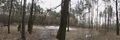
In Choboty forest, Novo-Peredelkino district. Which is actually, despite being called a forest, is more like a park.
Participants
Plans
To walk, perhaps. Depends on the weather mostly.
Expedition
~18.3km walk, home - hash - some sightseeing - train station
Tracklog

Not completely, but mostly cleared from GPS glitches.
Photos
Rumyantsevo (about half way to the hash)

Rumyantsevo still

Solntsevo, right next to Rumyantsevo
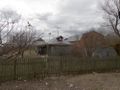
entering the park from Novoperedelkio side
destination reached
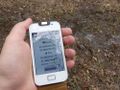
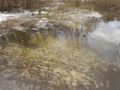
at the hash
leaving the park
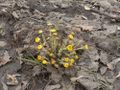
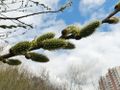
spring it is


Achievements
vb earned the Walk geohash Achievement
|