Difference between revisions of "2013-04-28 47 11"
From Geohashing
imported>LeslieHapablap (You're a hashcat!) |
imported>LeslieHapablap |
||
| Line 1: | Line 1: | ||
| + | {{Advert}} | ||
<!-- If you did not specify these parameters in the template, please substitute appropriate values for IMAGE, LAT, LON, and DATE (YYYY-MM-DD format) | <!-- If you did not specify these parameters in the template, please substitute appropriate values for IMAGE, LAT, LON, and DATE (YYYY-MM-DD format) | ||
| Line 74: | Line 75: | ||
<!-- Potential categories. Please include all the ones appropriate to your expedition --> | <!-- Potential categories. Please include all the ones appropriate to your expedition --> | ||
| − | [[Category:Expedition | + | [[Category:Expedition with photos]] |
| Line 84: | Line 85: | ||
[[Category:Expedition without GPS]] | [[Category:Expedition without GPS]] | ||
--> | --> | ||
| − | + | ||
| + | [[Category:Coordinates reached]] | ||
<!-- if you reached your coords: | <!-- if you reached your coords: | ||
[[Category:Coordinates reached]] | [[Category:Coordinates reached]] | ||
Revision as of 14:01, 28 April 2013
| Have you seen our geohashing marker? We'd love to hear from you! Click here to say "hi" and tell us what you've seen!
Curious about what geohashing is? Read more! |
| Sun 28 Apr 2013 in 47,11: 47.2958254, 11.4715725 geohashing.info google osm bing/os kml crox |
Location
In the middle of the village Thaur, opposite to the priest's office. Seems to be some kind of field, might be private ground.
Participants
on our very first hash.
Plans
We plan to go there by bike from Innsbruck, reaching the hash point at about 2pm. We will continue to Hall and then back to Innsbruck along the Inn.
The hash point should not be too hard to reach, except if it is private ground fiercely defended by locals.
Expedition
- Here we go... beautiful day! -- LeslieHapablap (talk) 07:26, 28 April 2013 (EDT)
- We reached the coordinates. This was way too easy, but a nice first hash. -- LeslieHapablap (talk) @47.2959,11.4717 08:04, 28 April 2013 (EDT)
Tracklog
Photos

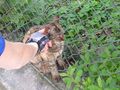
Our newly declared hashcot Waltraud learning about geohashing.
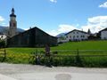
Nice location for a geohash.
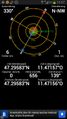
Proof we were there.

Obligatory stupid grin.

Another one with hashcot.
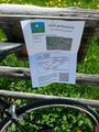
We left a marker.
You're a hashcat!


