Difference between revisions of "2013-04-30 52 20"
From Geohashing
imported>Norill (Created page with "{{subst:Expedition |lat = 52 |lon = 20 |date = 2013-04-30 }}") |
|||
| (3 intermediate revisions by 2 users not shown) | |||
| Line 19: | Line 19: | ||
== Location == | == Location == | ||
<!-- where you've surveyed the hash to be --> | <!-- where you've surveyed the hash to be --> | ||
| + | In a grove on the outskirts of Warsaw. | ||
== Participants == | == Participants == | ||
<!-- who attended: If you link to your wiki user name in this section, your expedition will be picked up by the various statistics generated for geohashing. You may use three tildes ~ as a shortcut to automatically insert the user signature of the account you are editing with. | <!-- who attended: If you link to your wiki user name in this section, your expedition will be picked up by the various statistics generated for geohashing. You may use three tildes ~ as a shortcut to automatically insert the user signature of the account you are editing with. | ||
--> | --> | ||
| + | *[[User:Norill|Norill]] | ||
| + | *[[User:Ziemba|Ziemba]] | ||
| + | *[[User:Ziemek|Ziemek]] | ||
== Plans == | == Plans == | ||
| Line 38: | Line 42: | ||
--> | --> | ||
<gallery perrow="5"> | <gallery perrow="5"> | ||
| + | Image:2013-04-30 52 20-1.JPG | Too much trash | ||
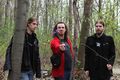
| + | Image:2013-04-30 52 20-2.JPG | Startled look | ||
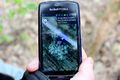
| + | Image:2013-04-30 52 20-3.JPG | Walking the monitor | ||
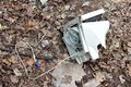
| + | Image:2013-04-30 52 20-4.JPG | Proof | ||
| + | Image:2013-04-30 52 20-5.JPG | Take it! Take it now! | ||
</gallery> | </gallery> | ||
| Line 43: | Line 52: | ||
{{#vardefine:ribbonwidth|800px}} | {{#vardefine:ribbonwidth|800px}} | ||
<!-- Add any achievement ribbons you earned below, or remove this section --> | <!-- Add any achievement ribbons you earned below, or remove this section --> | ||
| + | {{land geohash | ||
| + | | latitude = 52 | ||
| + | | longitude = 20 | ||
| + | | date = 2013-04-30 | ||
| + | | name = Ziemek, Ziemba & Norill | ||
| + | | image = 2013-04-30 52 20-4.JPG | ||
| + | }} | ||
| − | |||
| − | |||
| − | |||
| − | |||
| − | |||
| − | |||
| − | |||
| − | |||
| − | |||
| − | |||
[[Category:Expeditions]] | [[Category:Expeditions]] | ||
| − | |||
[[Category:Expeditions with photos]] | [[Category:Expeditions with photos]] | ||
| − | + | ||
| − | |||
| − | |||
| − | |||
| − | |||
[[Category:Coordinates reached]] | [[Category:Coordinates reached]] | ||
| − | + | {{location|PL|W|A}} | |
| − | |||
| − | |||
| − | |||
| − | |||
| − | |||
| − | |||
| − | |||
| − | |||
| − | |||
| − | |||
| − | |||
| − | |||
| − | |||
| − | |||
| − | |||
| − | |||
| − | |||
Latest revision as of 22:57, 10 March 2024
| Tue 30 Apr 2013 in 52,20: 52.2982955, 20.9384753 geohashing.info google osm bing/os kml crox |
Location
In a grove on the outskirts of Warsaw.
Participants
Plans
Expedition
Tracklog
Photos
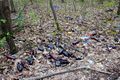
Too much trash

Startled look
Walking the monitor
Proof
Take it! Take it now!


Achievements
Ziemek, Ziemba & Norill earned the Land geohash achievement
|