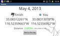
2013-05-04 33 -116
From Geohashing
Revision as of 02:10, 14 August 2019 by imported>FippeBot (Location)
| Sat 4 May 2013 in 33,-116: 33.0831226, -116.5235966 geohashing.info google osm bing/os kml crox |
Location
About a quarter-mile north of the western endpoint of the concurrency of the California Riding & Hiking Trail and CA State Route 78 in the Anza-Borrego Desert
Participants
Photos
Geohash Droid details page at the hashpoint
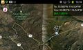
Map at the hashpoint

