Difference between revisions of "2013-05-11 54 -2"
imported>Mcbaneg |
imported>Mcbaneg |
||
| Line 1: | Line 1: | ||
| + | |||
| + | <!-- If you did not specify these parameters in the template, please substitute appropriate values for IMAGE, LAT, LON, and DATE (YYYY-MM-DD format) | ||
| + | |||
| + | [[Image:{{{image|IMAGE}}}|thumb|left]] | ||
| + | |||
| + | Remove this section if you don't want an image at the top (left) of your report. You should remove the "Image:" or "File:" | ||
| + | tag from your image file name, and replace the all upper-case word IMAGE in the above line. | ||
| + | |||
| + | And DON'T FORGET to add your expedition and the best photo you took to the gallery on the Main Page! We'd love to read your report, but that means we first have to discover it! :) | ||
| + | --> | ||
| + | {{meetup graticule | ||
| + | | lat=54 | ||
| + | | lon=-2 | ||
| + | | date=2013-05-11 | ||
| + | }} | ||
| + | |||
| + | <!-- edit as necessary --> | ||
| + | __NOTOC__ | ||
| + | == Location == | ||
| + | <!-- where you've surveyed the hash to be --> | ||
| + | |||
| + | == Participants == | ||
| + | <!-- who attended: If you link to your wiki user name in this section, your expedition will be picked up by the various statistics generated for geohashing. You may use three tildes ~ as a shortcut to automatically insert the user signature of the account you are editing with. | ||
| + | --> | ||
| + | |||
| + | == Plans == | ||
| + | <!-- what were the original plans --> | ||
| + | |||
| + | == Expedition == | ||
| + | <!-- how it all turned out. your narrative goes here. --> | ||
| + | |||
| + | == Tracklog == | ||
| + | <!-- if your GPS device keeps a log, you may post a link here --> | ||
| + | |||
| + | == Photos == | ||
| + | <!-- Insert pictures between the gallery tags using the following format: | ||
| + | Image:2012-##-## ## ## Alpha.jpg | Witty Comment | ||
| + | --> | ||
| + | <gallery perrow="5"> | ||
| + | </gallery> | ||
| + | |||
| + | == Achievements == | ||
| + | {{#vardefine:ribbonwidth|800px}} | ||
| + | <!-- Add any achievement ribbons you earned below, or remove this section --> | ||
| + | |||
| + | |||
| + | <!-- =============== USEFUL CATEGORIES FOLLOW ================ | ||
| + | Delete the next line ONLY if you have chosen the appropriate categories below. If you are unsure, don't worry. People will read your report and help you with the classification. --> | ||
| + | [[Category:New report]] | ||
| + | |||
| + | <!-- Potential categories. Please include all the ones appropriate to your expedition --> | ||
| + | <!-- If this is a planning page: | ||
| + | [[Category:Expedition planning]] | ||
| + | --> | ||
| + | |||
| + | <!-- An actual expedition: | ||
| + | [[Category:Expeditions]] | ||
| + | -- and one or more of -- | ||
| + | [[Category:Expeditions with photos]] | ||
| + | [[Category:Expeditions with videos]] | ||
| + | [[Category:Expedition without GPS]] | ||
| + | --> | ||
| + | |||
| + | <!-- if you reached your coords: | ||
| + | [[Category:Coordinates reached]] | ||
| + | |||
| + | |||
| + | --><!-- or if you failed :( | ||
| + | [[Category:Coordinates not reached]] | ||
| + | -- and a reason -- | ||
| + | When there is a natural obstacle between you and the target: | ||
| + | [[Category:Not reached - Mother Nature]] | ||
| + | |||
| + | When there is a man-made obstacle between you and the target: | ||
| + | [[Category:Not reached - No public access]] | ||
| + | |||
| + | When you failed get your GPS, car, bike or such to work: | ||
| + | [[Category:Not reached - Technology]] | ||
| + | |||
| + | When you went to an alternate location, or decided early on to abort the expedition: | ||
| + | [[Category:Not reached - Did not attempt]] | ||
| + | |||
| + | (Don't forget to delete this final close comment marker) --> | ||
| + | |||
| + | |||
| + | |||
[[Image:{{{image|IMG_2478.jpeg}}}|thumb|left]] | [[Image:{{{image|IMG_2478.jpeg}}}|thumb|left]] | ||
<!-- If you did not specify these parameters in the template, please substitute appropriate values for IMAGE, LAT, LON, and DATE (YYYY-MM-DD format) | <!-- If you did not specify these parameters in the template, please substitute appropriate values for IMAGE, LAT, LON, and DATE (YYYY-MM-DD format) | ||
Revision as of 10:12, 12 May 2013
| Sat 11 May 2013 in 54,-2: 54.8291249, -2.1022332 geohashing.info google osm bing/os kml crox |
Location
Participants
Plans
Expedition
Tracklog
Photos
Achievements

| Sat 11 May 2013 in 54,-2: 54.8291249, -2.1022332 geohashing.info google osm bing/os kml crox |
Location
A pasture on the northwest bank of Nookton Beck, about 4 miles WSW of Derwent Reservoir, County Durham, UK.
Participants
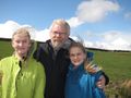
George McBane Mcbaneg (talk) Susanne Buchau (official expedition photographer) Katja McBane Rebekah McBane
Expedition
Pretty straightforward navigation on rural roads, followed by an easy half mile walk across pasture, in the lovely northern Durham Dales. No GPS, and in this rural valley the smartphone didn't have enough signal to give us a location marker, so once on foot we navigated from memory of the Peeron Map I had studied that morning.
Photos

This shot was taken looking SW across Nookton Beck to Crosshill Farm. I have marked two sightlines. On the right the view is nearly in line with a stone wall on the opposite bank. On the left there is a prominent tree on the near side of the beck, and the sightline leads up the hill on the opposite side to the junction between the third and fourth segments of the main farm buildings. These don't meet at the bottom of the image, so their actual intersection must be a little way behind the photographer because of the camera's spherical-to-flat mapping.
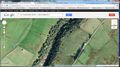
This is the satellite image of the hashpoint area, including the beck and Crosshill Farm. I have marked the same two sightlines on the map; they intersect nearly at the tractor road and wall at the top of the pasture. The photo was taken some way down the hill from that road, nearer the marked hashpoint. A third line marked on the map shows the line of a second stone wall a little farther up the opposite hill. From the site photo it's clear that the line of this second wall passes in front of the photographer, from right to left. My best guess is that the photo was taken from a spot about 80 feet due west of the true hashpoint.


There's a reason wind power is popular around here.
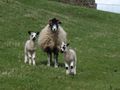
We didn't meet any other geohashers but we did speak with some local residents.
