Difference between revisions of "2013-05-12 48 9"
From Geohashing
imported>Lucwerk (→Participants: Adding myself as a participant) |
imported>FippeBot m (Location) |
||
| (4 intermediate revisions by 2 users not shown) | |||
| Line 19: | Line 19: | ||
== Location == | == Location == | ||
<!-- where you've surveyed the hash to be --> | <!-- where you've surveyed the hash to be --> | ||
| + | Behind the Oberer See in Böblingen, in someone's garden. | ||
== Participants == | == Participants == | ||
| Line 30: | Line 31: | ||
== Expedition == | == Expedition == | ||
<!-- how it all turned out. your narrative goes here. --> | <!-- how it all turned out. your narrative goes here. --> | ||
| + | My first expedition, so it's a bit derped up. | ||
| + | |||
| + | As it was just 3.5km from my house, I just drove there with my bike (hence few pictures of the expedition itself). A nice and mostly sunny sunday afternoon, although it did get cloudy later (and even rained). | ||
| + | |||
| + | <gallery> | ||
| + | Image:2013-05-12 48 9 Panorama.jpg|I think the hash point is somewhere in this garden, but it might have been one house further west. | ||
| + | Image:2013-05-12 48 9 Parking site.jpg|The view when turning around. I think I recognized this parking area from the aerial picture, but I'm not sure. | ||
| + | Image:2013-05-12 48 9 Oberer See.jpg|The Oberer See (upper lake) was just a few hundred meters north. I missed my train by a few minutes, and so I enjoyed this nice spring afternoon here. | ||
| + | </gallery> | ||
== Tracklog == | == Tracklog == | ||
| Line 43: | Line 53: | ||
== Achievements == | == Achievements == | ||
{{#vardefine:ribbonwidth|800px}} | {{#vardefine:ribbonwidth|800px}} | ||
| − | + | {{land geohash | |
| − | + | | latitude = 48 | |
| − | + | | longitude = 9 | |
| − | + | | date = 2013-05-12 | |
| − | + | | name = Lucwerk | |
| − | + | }} | |
| − | |||
| − | |||
| − | |||
| − | |||
| − | |||
| − | |||
[[Category:Expeditions]] | [[Category:Expeditions]] | ||
| − | + | [[Category:Coordinates reached]] | |
[[Category:Expeditions with photos]] | [[Category:Expeditions with photos]] | ||
| − | + | <!-- Judging by the aerials from Google this one looks doable. (Palmpje, 6 June 2013) --> | |
| − | + | {{location|DE|BW|BB}} | |
| − | |||
| − | |||
| − | <!-- | ||
| − | |||
| − | |||
| − | |||
| − | |||
| − | |||
| − | |||
| − | |||
| − | |||
| − | |||
| − | |||
| − | |||
| − | |||
| − | |||
| − | |||
| − | |||
| − | |||
| − | |||
| − | |||
| − | |||
Latest revision as of 02:18, 14 August 2019
| Sun 12 May 2013 in 48,9: 48.6778850, 9.0141189 geohashing.info google osm bing/os kml crox |
Location
Behind the Oberer See in Böblingen, in someone's garden.
Participants
Plans
Expedition
My first expedition, so it's a bit derped up.
As it was just 3.5km from my house, I just drove there with my bike (hence few pictures of the expedition itself). A nice and mostly sunny sunday afternoon, although it did get cloudy later (and even rained).

I think the hash point is somewhere in this garden, but it might have been one house further west.
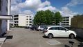
The view when turning around. I think I recognized this parking area from the aerial picture, but I'm not sure.
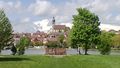
The Oberer See (upper lake) was just a few hundred meters north. I missed my train by a few minutes, and so I enjoyed this nice spring afternoon here.


Tracklog
Photos
Achievements
Lucwerk earned the Land geohash achievement
|