Difference between revisions of "2013-05-13 45 -123"
From Geohashing
imported>Michael5000 m (→Achievements) |
imported>FippeBot m (Location) |
||
| (3 intermediate revisions by 2 users not shown) | |||
| Line 1: | Line 1: | ||
| − | |||
| − | |||
| − | |||
| − | |||
| − | |||
| − | |||
| − | |||
| − | |||
| − | |||
| − | |||
{{meetup graticule | {{meetup graticule | ||
| lat=45 | | lat=45 | ||
| Line 15: | Line 5: | ||
}} | }} | ||
| − | |||
__NOTOC__ | __NOTOC__ | ||
== Location == | == Location == | ||
| Line 27: | Line 16: | ||
== Plans == | == Plans == | ||
| − | I woke up feeling lazy and decided to play hooky. Hadn't done a geohash in | + | I woke up feeling lazy and decided to play hooky. Hadn't done a geohash in about nine months, and, well, one thing led to another. |
== Expedition == | == Expedition == | ||
For a narrow farm road with not much going on in the way of a shoulder, Zion Church Road is pretty damn busy on a weekday morning. I went across the hashpoint four times without really feeling like it was safe to stop, led alone chalk up the road or anything else. The photo is looking east bound, and I pushed the button as I saw 0.0 on my GPS. | For a narrow farm road with not much going on in the way of a shoulder, Zion Church Road is pretty damn busy on a weekday morning. I went across the hashpoint four times without really feeling like it was safe to stop, led alone chalk up the road or anything else. The photo is looking east bound, and I pushed the button as I saw 0.0 on my GPS. | ||
| − | |||
| − | |||
| − | |||
== Photos == | == Photos == | ||
| − | |||
| − | |||
| − | |||
<gallery perrow="5"> | <gallery perrow="5"> | ||
| + | Image:2013-05-13 45 -123 road.jpg|View from the Hashpoint. | ||
| + | Image:2013-05-13 45 -123 sign.jpg|Sign at the nearest intersection. | ||
</gallery> | </gallery> | ||
| − | |||
| − | |||
| − | |||
| − | |||
| − | |||
| − | |||
[[Category:Expeditions]] | [[Category:Expeditions]] | ||
[[Category:Expeditions with photos]] | [[Category:Expeditions with photos]] | ||
[[Category:Coordinates reached]] | [[Category:Coordinates reached]] | ||
| + | {{location|US|OR|WI}} | ||
Latest revision as of 02:20, 14 August 2019
| Mon 13 May 2013 in 45,-123: 45.5722309, -123.0394874 geohashing.info google osm bing/os kml crox |
Location
On Zion Church Road northwest of Hillsboro.
Participants
Plans
I woke up feeling lazy and decided to play hooky. Hadn't done a geohash in about nine months, and, well, one thing led to another.
Expedition
For a narrow farm road with not much going on in the way of a shoulder, Zion Church Road is pretty damn busy on a weekday morning. I went across the hashpoint four times without really feeling like it was safe to stop, led alone chalk up the road or anything else. The photo is looking east bound, and I pushed the button as I saw 0.0 on my GPS.
Photos
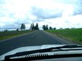
View from the Hashpoint.
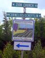
Sign at the nearest intersection.

