Difference between revisions of "2013-05-15 47 -122"
From Geohashing
imported>Thomcat ([live picture] No trespass, natch [http://www.openstreetmap.org/?lat=47.68270643&lon=-122.31204922&zoom=16&layers=B000FTF @47.6827,-122.3120]) |
imported>Thomcat ([live] That's as close as I get.) |
||
| Line 20: | Line 20: | ||
<!-- how it all turned out. your narrative goes here. --> | <!-- how it all turned out. your narrative goes here. --> | ||
| + | |||
| + | *That's as close as I get. -- [[User:Thomcat|Thomcat]] ([[User talk:Thomcat|talk]]) [http://www.openstreetmap.org/?lat=47.68061362&lon=-122.31210866&zoom=16&layers=B000FTF @47.6806,-122.3121] 12:26, 15 May 2013 (PDT) | ||
== Tracklog == | == Tracklog == | ||
<!-- if your GPS device keeps a log, you may post a link here --> | <!-- if your GPS device keeps a log, you may post a link here --> | ||
Revision as of 19:27, 15 May 2013
| Wed 15 May 2013 in Seattle: 47.6810543, -122.3124297 geohashing.info google osm bing/os kml crox |
Location
Inside the Roosevelt Reservoir in Seattle.
Participants
Plans
Likely no public access, but worth a lunchtime visit. Will visit after picking up Spud fish & chips.
Expedition
- That's as close as I get. -- Thomcat (talk) @47.6806,-122.3121 12:26, 15 May 2013 (PDT)
Tracklog
Photos
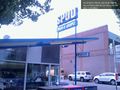
Spud! @47.6784,-122.3270
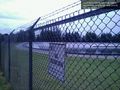
No trespass, natch @47.6827,-122.3120


Achievements