Difference between revisions of "2013-05-17 55 37"
From Geohashing
imported>Vb (→Expedition) |
imported>FippeBot m (Location) |
||
| (8 intermediate revisions by one other user not shown) | |||
| Line 20: | Line 20: | ||
<!-- where you've surveyed the hash to be --> | <!-- where you've surveyed the hash to be --> | ||
| − | + | Near Lihachevskoe hwy. Technically, in town Dolgoprudnyj, just north from Moscow. | |
| − | |||
== Participants == | == Participants == | ||
| Line 27: | Line 26: | ||
* [[User:Vb|vb]] | * [[User:Vb|vb]] | ||
| + | == Expedition == | ||
| + | <!-- how it all turned out. your narrative goes here. --> | ||
| − | + | Hash is on unused space with new housing development to the west and south, an old village with a new big church to the north, and the highway to the east. | |
| − | |||
| − | + | A big cemetery and a mountain of city's waste to the south-east. Quite similar to the mountain near Khovanskoye Cemetery (cf. [[2012-09-01 55 37]]), but this one is still functional. | |
| − | |||
| Line 41: | Line 40: | ||
*Coordinates reached. Photos made. Marker placed. Riding bus back to the city. -- [[User:Vb|vb]] ([[User talk:Vb|talk]]) [http://www.openstreetmap.org/?lat=55.85915509&lon=37.48912322&zoom=16&layers=B000FTF @55.8592,37.4891] 10:00, 17 May 2013 (EDT) | *Coordinates reached. Photos made. Marker placed. Riding bus back to the city. -- [[User:Vb|vb]] ([[User talk:Vb|talk]]) [http://www.openstreetmap.org/?lat=55.85915509&lon=37.48912322&zoom=16&layers=B000FTF @55.8592,37.4891] 10:00, 17 May 2013 (EDT) | ||
| − | == | + | == Photos == |
| − | < | + | <gallery perrow="5"> |
| + | Image:2013-05-17_55_37 P1000793.jpg | Coordinates reached | ||
| + | </gallery> | ||
| + | <gallery perrow="5"> | ||
| + | Image:2013-05-17_55_37 P1000794.jpg | north -- east -- south | ||
| + | Image:2013-05-17_55_37 P1000796.jpg | south-west | ||
| + | Image:2013-05-17_55_37 P1000797.jpg | west | ||
| + | Image:2013-05-17_55_37 P1000799.jpg | north | ||
| + | Image:2013-05-17_55_37 P1000804.jpg | south | ||
| + | </gallery> | ||
| + | |||
| + | More of the church: | ||
| + | <gallery perrow="5"> | ||
| + | Image:2013-05-17 55 37 P1000762.jpg | ||
| + | Image:2013-05-17 55 37 P1000768.jpg | ||
| + | Image:2013-05-17 55 37 P1000770.jpg | ||
| + | Image:2013-05-17 55 37 P1000774.jpg | ||
| + | Image:2013-05-17 55 37 P1000783.jpg | ||
| + | </gallery> | ||
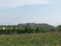
| − | + | More of the garbage dump: | |
| − | |||
| − | |||
| − | |||
<gallery perrow="5"> | <gallery perrow="5"> | ||
| + | Image:2013-05-17 55 37 P1000814.jpg | ||
| + | Image:2013-05-17 55 37 P1000819.jpg | ||
| + | Image:2013-05-17 55 37 P1000815.jpg | ||
| + | Image:2013-05-17 55 37 P1000820.jpg | ||
| + | Image:2013-05-17 55 37 P1000812.jpg | ||
</gallery> | </gallery> | ||
| Line 54: | Line 73: | ||
{{#vardefine:ribbonwidth|800px}} | {{#vardefine:ribbonwidth|800px}} | ||
<!-- Add any achievement ribbons you earned below, or remove this section --> | <!-- Add any achievement ribbons you earned below, or remove this section --> | ||
| − | |||
| − | |||
| − | |||
| − | |||
| − | |||
| − | |||
| − | |||
[[Category:Expeditions]] | [[Category:Expeditions]] | ||
[[Category:Expeditions with photos]] | [[Category:Expeditions with photos]] | ||
[[Category:Coordinates reached]] | [[Category:Coordinates reached]] | ||
| − | + | [[Category:Land geohash achievement]] | |
| − | + | [[Category:Public transport geohash achievement]] | |
| − | + | {{location|RU|MOS}} | |
| − | |||
| − | |||
| − | |||
| − | |||
| − | |||
| − | [[Category: | ||
| − | |||
| − | |||
| − | |||
| − | [[Category: | ||
| − | |||
| − | |||
| − | |||
| − | |||
| − | |||
| − | |||
| − | |||
| − | |||
| − | |||
| − | |||
| − | |||
| − | |||
| − | |||
| − | |||
| − | |||
| − | |||
| − | |||
| − | |||
Latest revision as of 02:22, 14 August 2019
| Fri 17 May 2013 in 55,37: 55.9155584, 37.4932517 geohashing.info google osm bing/os kml crox |
Location
Near Lihachevskoe hwy. Technically, in town Dolgoprudnyj, just north from Moscow.
Participants
Expedition
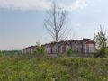
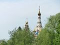
Hash is on unused space with new housing development to the west and south, an old village with a new big church to the north, and the highway to the east.
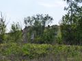
A big cemetery and a mountain of city's waste to the south-east. Quite similar to the mountain near Khovanskoye Cemetery (cf. 2012-09-01 55 37), but this one is still functional.
- The plan for today's hash is: home - (metro) - lunch - (metro) - Savelovskiy vokzal (a central railway station) - suburban train (~23 min) - and finally about half an hour walk to the hash. About 2h to the hash in total. (not counting the lunch)
Currently had lunch and moving in the direction of the vokzal. -- vb (talk) @55.7258,37.6138 07:13, 17 May 2013 (EDT)
- Coordinates reached. Photos made. Marker placed. Riding bus back to the city. -- vb (talk) @55.8592,37.4891 10:00, 17 May 2013 (EDT)
Photos

Coordinates reached

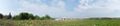
north -- east -- south
south-west
west
north
south


More of the church:


More of the garbage dump:


