Difference between revisions of "2013-05-20 51 10"
From Geohashing
imported>Rincewind (→Expedition) |
imported>FippeBot m (Location) |
||
| (One intermediate revision by one other user not shown) | |||
| Line 22: | Line 22: | ||
== Gallery== | == Gallery== | ||
<gallery> | <gallery> | ||
| − | Image:2013-05-10 | + | Image:2013-05-20 51 10 hasharea.jpg | Hash coordinates 10m behind hasher |
| + | Image:2013-05-20 51 10 hashgrin.jpg | Tired on the left, stupid grin on the right | ||
| + | Image:2013-05-20 51 10 hashproof.jpg | Coordinates reached | ||
| + | |||
| + | Image:2013-05-20 51 10 muehlburg.jpg | Go visit castle Mühlberg ("Mühlburg") | ||
| + | Image:2013-05-20 51 10 wachsenburg.jpg | ...and private-owned Wachsenburg. Gleichenburg is under reconstruction work currently. | ||
</gallery> | </gallery> | ||
| Line 39: | Line 44: | ||
[[Category:Expeditions with photos]] | [[Category:Expeditions with photos]] | ||
[[Category:Coordinates reached]] | [[Category:Coordinates reached]] | ||
| + | {{location|DE|TH|GTH}} | ||
Latest revision as of 02:25, 14 August 2019
| Mon 20 May 2013 in 51,10: 51.0547253, 10.7881194 geohashing.info google osm bing/os kml crox |
Location
Near a forest track in Großfahner (Thuringia)
Participants
Plans
We wanted to use the good weather this morning and go to see a castle ensemble named "Drei Gleichen" (three alike). Afterwards a detour to the closest geohash point.
Expedition
As planned, we visited the three castles (Gleichen, Mühlburg, Wachsenburg). Then Rincewind drove to the geohash point. We were lucky to arrive at a forest track and follow the "road". A few metres off, we easily reached the coordinates.
Gallery

Hash coordinates 10m behind hasher

Tired on the left, stupid grin on the right
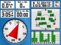
Coordinates reached
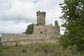
Go visit castle Mühlberg ("Mühlburg")
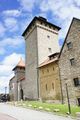
...and private-owned Wachsenburg. Gleichenburg is under reconstruction work currently.


Achievements
Yakamoz and Rincewind earned the Land geohash achievement
|