Difference between revisions of "2013-05-21 -35 149"
From Geohashing
imported>1PE (running out of time. I'll complete later.) |
m (More specific location) |
||
| (4 intermediate revisions by 3 users not shown) | |||
| Line 1: | Line 1: | ||
| − | |||
| − | |||
| − | |||
| − | |||
| − | |||
| − | |||
| − | |||
| − | |||
| − | |||
| − | |||
{{meetup graticule | {{meetup graticule | ||
| lat=-35 | | lat=-35 | ||
| Line 15: | Line 5: | ||
}} | }} | ||
| − | |||
__NOTOC__ | __NOTOC__ | ||
== Location == | == Location == | ||
[[Geohashing Day]] 2013: | [[Geohashing Day]] 2013: | ||
* '''2013''': In the remote Talagandra State Forest, off the Braidwood-Cooma Road, about 120km along mostly remote country roads from Canberra, then a hike of several hours to the hash. | * '''2013''': In the remote Talagandra State Forest, off the Braidwood-Cooma Road, about 120km along mostly remote country roads from Canberra, then a hike of several hours to the hash. | ||
| − | * 2003: (YES, the "10th anniversary" hash: [[2003-05-21 -35 149]]) On the lip of a hard-rock mine at Mount Mugga, off Mugga Lane. So, also inaccessible, and unsafe to get to. So, I ([[User:1PE|1PE]]) will make best efforts to take a picture of the site from an adjacent road. | + | * 2003: (YES, the "10th anniversary" hash: [[2003-05-21 -35 149]]) On the lip of a hard-rock mine at Mount Mugga, off Mugga Lane, in eastern Canberra. So, also inaccessible, and unsafe to get to. So, I ([[User:1PE|1PE]]) will make best efforts to take a picture of the site from an adjacent road. |
== Participants == | == Participants == | ||
| Line 29: | Line 18: | ||
== Expedition == | == Expedition == | ||
| − | + | I attended my meeting. I then went to th road nearest to the west of the hash, from where I could see the mine site scar. Pictures too several minutes only. | |
| − | |||
| − | |||
| − | |||
== Photos == | == Photos == | ||
| − | |||
| − | |||
| − | |||
<gallery perrow="5"> | <gallery perrow="5"> | ||
| − | Image:2013-05-21 -35 149 14.48.51.jpg|Looking east (ok, I am looking west) to the mine site, with the | + | Image:2013-05-21 -35 149 14.48.51.jpg|Looking east (ok, I am looking west) to the mine site, with the hash near the 'gash' visible at the summit. |
</gallery> | </gallery> | ||
== Achievements == | == Achievements == | ||
{{#vardefine:ribbonwidth|800px}} | {{#vardefine:ribbonwidth|800px}} | ||
| + | {{Geohashing Day | ||
| + | | latitude = -35 | ||
| + | | longitude = 149 | ||
| + | | year = 2013/2003 | ||
| + | | coorddate= 2003-05-21 | ||
| + | | celebration = celebrated by getting NEAR the 2003 (10th 'anniverssary') hash | ||
| + | | image = 2013-05-21 -35 149 14.48.51.jpg | ||
| + | }} | ||
<!-- Add any achievement ribbons you earned below, or remove this section --> | <!-- Add any achievement ribbons you earned below, or remove this section --> | ||
| − | |||
| − | |||
| − | |||
[[Category:Expeditions]] | [[Category:Expeditions]] | ||
| − | |||
[[Category:Expeditions with photos]] | [[Category:Expeditions with photos]] | ||
| − | |||
[[Category:Expedition without GPS]] | [[Category:Expedition without GPS]] | ||
| − | |||
| − | |||
| − | |||
| − | |||
| − | |||
| − | |||
[[Category:Coordinates not reached]] | [[Category:Coordinates not reached]] | ||
| − | |||
| − | |||
| − | |||
| − | |||
| − | |||
[[Category:Not reached - No public access]] | [[Category:Not reached - No public access]] | ||
| − | + | {{location|AU|NSW|SM}} | |
| − | |||
| − | |||
| − | |||
| − | |||
| − | |||
| − | |||
| − | |||
Latest revision as of 12:37, 1 August 2020
| Tue 21 May 2013 in -35,149: -35.7030771, 149.2446807 geohashing.info google osm bing/os kml crox |
Location
Geohashing Day 2013:
- 2013: In the remote Talagandra State Forest, off the Braidwood-Cooma Road, about 120km along mostly remote country roads from Canberra, then a hike of several hours to the hash.
- 2003: (YES, the "10th anniversary" hash: 2003-05-21 -35 149) On the lip of a hard-rock mine at Mount Mugga, off Mugga Lane, in eastern Canberra. So, also inaccessible, and unsafe to get to. So, I (1PE) will make best efforts to take a picture of the site from an adjacent road.
Participants
Plans
I have a meeting appointment near the 2003 hash at around lunchtime.
Expedition
I attended my meeting. I then went to th road nearest to the west of the hash, from where I could see the mine site scar. Pictures too several minutes only.
Photos
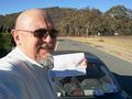
Looking east (ok, I am looking west) to the mine site, with the hash near the 'gash' visible at the summit.

Achievements
This user earned the 2013/2003 Geohashing Day achievement
|