Difference between revisions of "2013-05-22 1 103"
imported>Cyazlars (Closest I could get) |
imported>FippeBot m (Location) |
||
| (3 intermediate revisions by one other user not shown) | |||
| Line 18: | Line 18: | ||
__NOTOC__ | __NOTOC__ | ||
== Location == | == Location == | ||
| − | + | In a forested area along Canberra Road, just 1.4km from my house | |
== Participants == | == Participants == | ||
| − | + | [[User:Cyazlars|Cyazlars]] | |
| − | |||
| − | |||
| − | |||
| − | |||
== Expedition == | == Expedition == | ||
| − | + | I had forgotten to check the day's coordinates earlier, and only remembered to just before I left for a day trip around Johor Baru with my family. Seeing that it was basically within walking distance (or a really quick bus ride), and it had been so long since I last went on a geohash attempt... I was a little put off by the forest surrounding the hash, though. My brother told me that there was a construction site in the field near the hashpoint, and I'd be able to get there by just skirting around the fence. Satisfied with that plan, I told my parents I'd catch up with them at JB Sentral later. | |
| − | + | Took bus 856 from my house and alighted just after Assyafaah Mosque. It didn't look like I could go around it as planned, so I walked further down to see if I could climb over the railing beside the road into the forested area. As I followed my phone GPS, I realised that the geohash was pretty much impossible to get to unless I fancied crossing a small stream and whacking my way through some dense foliage. Possibly encountering pythons in the grass, too. I didn't have time to try and perhaps find an easier route to it, so I gave up and took another 856 to Woodlands Checkpoint. | |
| − | |||
== Photos == | == Photos == | ||
| − | |||
| − | |||
| − | |||
<gallery perrow="5"> | <gallery perrow="5"> | ||
| − | Image:2013-05-22_1_103_12-13-40-108.jpg | Construction site near hashpoint, but that' | + | Image:2013-05-22_1_103_12-13-40-108.jpg | Construction site near hashpoint, but that wasn't the problem... |
| − | + | Image:2013-05-22 1 103 12-23-07-694.jpg | ...this was. | |
| − | Image:2013-05-22_1_103_12-19-53-767.jpg | Closest I could get | + | Image:2013-05-22_1_103_12-19-53-767.jpg | Closest I could get. |
</gallery> | </gallery> | ||
| − | |||
| − | |||
| − | |||
| − | |||
| − | |||
| − | |||
| − | |||
| − | |||
| − | |||
| − | |||
| − | |||
| − | |||
| − | |||
| − | |||
| − | |||
[[Category:Expeditions]] | [[Category:Expeditions]] | ||
| − | |||
[[Category:Expeditions with photos]] | [[Category:Expeditions with photos]] | ||
| − | |||
| − | |||
| − | |||
| − | |||
| − | |||
| − | |||
| − | |||
| − | |||
| − | |||
[[Category:Coordinates not reached]] | [[Category:Coordinates not reached]] | ||
| − | |||
| − | |||
[[Category:Not reached - Mother Nature]] | [[Category:Not reached - Mother Nature]] | ||
| − | + | {{location|SG|NW}} | |
| − | |||
| − | |||
| − | |||
| − | |||
| − | |||
| − | |||
| − | |||
| − | |||
| − | |||
| − | |||
Latest revision as of 02:27, 14 August 2019
| Wed 22 May 2013 in 1,103: 1.4576469, 103.8207017 geohashing.info google osm bing/os kml crox |
Location
In a forested area along Canberra Road, just 1.4km from my house
Participants
Expedition
I had forgotten to check the day's coordinates earlier, and only remembered to just before I left for a day trip around Johor Baru with my family. Seeing that it was basically within walking distance (or a really quick bus ride), and it had been so long since I last went on a geohash attempt... I was a little put off by the forest surrounding the hash, though. My brother told me that there was a construction site in the field near the hashpoint, and I'd be able to get there by just skirting around the fence. Satisfied with that plan, I told my parents I'd catch up with them at JB Sentral later.
Took bus 856 from my house and alighted just after Assyafaah Mosque. It didn't look like I could go around it as planned, so I walked further down to see if I could climb over the railing beside the road into the forested area. As I followed my phone GPS, I realised that the geohash was pretty much impossible to get to unless I fancied crossing a small stream and whacking my way through some dense foliage. Possibly encountering pythons in the grass, too. I didn't have time to try and perhaps find an easier route to it, so I gave up and took another 856 to Woodlands Checkpoint.
Photos
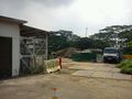
Construction site near hashpoint, but that wasn't the problem...
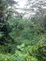
...this was.
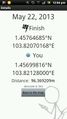
Closest I could get.


