Difference between revisions of "2013-05-22 39 -76"
imported>OfficeLinebacker ([live picture] The view to the north [http://www.openstreetmap.org/?lat=39.01136330&lon=-76.95442203&zoom=16&layers=B000FTF @39.0114,-76.9544]) |
imported>FippeBot m (Location) |
||
| (7 intermediate revisions by 3 users not shown) | |||
| Line 1: | Line 1: | ||
| − | |||
| − | |||
| − | |||
| − | |||
| − | |||
| − | |||
| − | |||
| − | |||
| − | |||
| − | |||
{{meetup graticule | {{meetup graticule | ||
| lat=39 | | lat=39 | ||
| Line 19: | Line 9: | ||
== Location == | == Location == | ||
<!-- where you've surveyed the hash to be --> | <!-- where you've surveyed the hash to be --> | ||
| + | In a forest next to the wide mowed area for power lines in College Park, MD | ||
== Participants == | == Participants == | ||
<!-- who attended: If you link to your wiki user name in this section, your expedition will be picked up by the various statistics generated for geohashing. You may use three tildes ~ as a shortcut to automatically insert the user signature of the account you are editing with. | <!-- who attended: If you link to your wiki user name in this section, your expedition will be picked up by the various statistics generated for geohashing. You may use three tildes ~ as a shortcut to automatically insert the user signature of the account you are editing with. | ||
--> | --> | ||
| + | [[User:OfficeLinebacker|OfficeLinebacker]] ([[User talk:OfficeLinebacker|talk]]) | ||
== Plans == | == Plans == | ||
<!-- what were the original plans --> | <!-- what were the original plans --> | ||
| + | Saw the spot, it's only 20 mins away, thought a road went very close, decided to try. A spur of the moment kind of thing. | ||
== Expedition == | == Expedition == | ||
<!-- how it all turned out. your narrative goes here. --> | <!-- how it all turned out. your narrative goes here. --> | ||
| + | It was a beautiful, hot, sunny day and I decided to head out while I was on a conference call. I love the mowed areas where large transmission lines travel the earth. On the way there, I was actually participating in a work thing. The call went long and even as I got out of my car and started walking down a path (that on the map looked like a road), I was on the call. | ||
| + | |||
| + | Got out into the mowed area and got close to the spot along the edge of the forest that was closest to the point and waited for the call to end before I sallied into the woods. | ||
| + | |||
| + | Into the woods I went, not directly from the closest spot due to vegetation, but it was still fairly straightforward. Snapped my pics and went home. | ||
== Tracklog == | == Tracklog == | ||
| Line 48: | Line 46: | ||
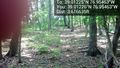
Image:2013-05-22_39_-76_14-42-34-269.jpg | The view to the north [http://www.openstreetmap.org/?lat=39.01136330&lon=-76.95442203&zoom=16&layers=B000FTF @39.0114,-76.9544] | Image:2013-05-22_39_-76_14-42-34-269.jpg | The view to the north [http://www.openstreetmap.org/?lat=39.01136330&lon=-76.95442203&zoom=16&layers=B000FTF @39.0114,-76.9544] | ||
| + | |||
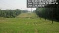
| + | Image:2013-05-22_39_-76_14-43-00-635.jpg | The view to the south [http://www.openstreetmap.org/?lat=39.01136233&lon=-76.95441950&zoom=16&layers=B000FTF @39.0114,-76.9544] | ||
</gallery> | </gallery> | ||
| Line 54: | Line 54: | ||
<!-- Add any achievement ribbons you earned below, or remove this section --> | <!-- Add any achievement ribbons you earned below, or remove this section --> | ||
| − | |||
| − | |||
| − | |||
| − | |||
| − | |||
| − | |||
| − | |||
| − | |||
| − | |||
| − | |||
| − | |||
[[Category:Expeditions]] | [[Category:Expeditions]] | ||
| − | |||
[[Category:Expeditions with photos]] | [[Category:Expeditions with photos]] | ||
| − | |||
| − | |||
| − | |||
| − | |||
| − | |||
[[Category:Coordinates reached]] | [[Category:Coordinates reached]] | ||
| − | + | {{location|US|MD|PR}} | |
| − | |||
| − | |||
| − | |||
| − | |||
| − | |||
| − | |||
| − | |||
| − | |||
| − | |||
| − | |||
| − | |||
| − | |||
| − | |||
| − | |||
| − | |||
| − | |||
| − | |||
Latest revision as of 02:28, 14 August 2019
| Wed 22 May 2013 in 39,-76: 39.0122519, -76.9546343 geohashing.info google osm bing/os kml crox |
Location
In a forest next to the wide mowed area for power lines in College Park, MD
Participants
Plans
Saw the spot, it's only 20 mins away, thought a road went very close, decided to try. A spur of the moment kind of thing.
Expedition
It was a beautiful, hot, sunny day and I decided to head out while I was on a conference call. I love the mowed areas where large transmission lines travel the earth. On the way there, I was actually participating in a work thing. The call went long and even as I got out of my car and started walking down a path (that on the map looked like a road), I was on the call.
Got out into the mowed area and got close to the spot along the edge of the forest that was closest to the point and waited for the call to end before I sallied into the woods.
Into the woods I went, not directly from the closest spot due to vegetation, but it was still fairly straightforward. Snapped my pics and went home.
Tracklog
Photos
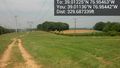
The spot @39.0123,-76.9546
The view to the north @39.0114,-76.9544
The view to the south @39.0114,-76.9544


