Difference between revisions of "2013-05-24 -37 145"
imported>Lachie (→Participants) |
|||
| (10 intermediate revisions by 6 users not shown) | |||
| Line 1: | Line 1: | ||
| − | + | [[File:2013-05-24 -37 145us.JPG|thumb|left]] | |
| − | |||
| − | |||
| − | |||
| − | |||
| − | |||
| − | |||
| − | |||
| − | |||
{{meetup graticule | {{meetup graticule | ||
| lat=-37 | | lat=-37 | ||
| Line 28: | Line 20: | ||
*Matthea | *Matthea | ||
*Claire | *Claire | ||
| − | *Cam | + | *[[User:Cam (2013)|Cam]] |
== Plans == | == Plans == | ||
| Line 34: | Line 26: | ||
== Expedition == | == Expedition == | ||
| − | + | Cam and Lachlan were riding to a party in Surrey Hills so this Hash wasn't too much of a detour, Talex and Stevage were also planning on going to the hash so we agreed to meet up where the Main Yarra Trail crosses Burke road and ride up along the trail together from there. Aimee and Claire (who had come on separate expeditions with me before[[Image:Arrow2.png|12px]] [[2012-06-30_-38_145]] and [[image:arrow2.png|12px]] [[2013-02-17_-37_145]]) and Alex and Matthea (who were sick of hearing us talking about geohashing) were heading to the same party in Aimee's car were keen to come too. | |
| + | |||
| + | The eight of us met up at the closest entrance to the park from the road on The Boulevard to complete the final leg on foot. The car crew had dressed for a party rather than geohashing and were hesitant about walking around in the mud but were convinced by the path that would take us most of the way. We got as far an the path would take us and turned off into a muddy paddock which required us to clime over a thankfully-off electric fence. Hash reached at 8:05. | ||
| + | |||
| + | After a few happy snaps which we struggled to get all eight of us in we returned to the car and then went our separate ways. The only casualty of the trip was Matthea's shoe RIP. | ||
*Geohash success -- [[User:Talex|Talex]] ([[User talk:Talex|talk]]) [http://www.openstreetmap.org/?lat=-37.76430099&lon=145.07280222&zoom=16&layers=B000FTF @-37.7643,145.0728] 20:05, 24 May 2013 (AEST) | *Geohash success -- [[User:Talex|Talex]] ([[User talk:Talex|talk]]) [http://www.openstreetmap.org/?lat=-37.76430099&lon=145.07280222&zoom=16&layers=B000FTF @-37.7643,145.0728] 20:05, 24 May 2013 (AEST) | ||
| + | |||
== Tracklog == | == Tracklog == | ||
<!-- if your GPS device keeps a log, you may post a link here --> | <!-- if your GPS device keeps a log, you may post a link here --> | ||
| Line 48: | Line 45: | ||
Image:2013-05-24_-37_145_20-05-44-549.jpg | [http://www.openstreetmap.org/?lat=-37.76430461&lon=145.07281240&zoom=16&layers=B000FTF @-37.7643,145.0728] | Image:2013-05-24_-37_145_20-05-44-549.jpg | [http://www.openstreetmap.org/?lat=-37.76430461&lon=145.07281240&zoom=16&layers=B000FTF @-37.7643,145.0728] | ||
| + | Image:2013-05-24 -37 145us.JPG|All eight of us looking down at the hash. | ||
| + | Image:2013-05-24 -37 145Men.JPG | The men of the group up a tree. | ||
| + | Image:2013-05-24 -37 145ladies.JPG | Alex, Matthea, Claire and Aimee looking beautiful at the hash. | ||
| + | Image:2013-05-24 -37 145heels.JPG | Geohashing in high heels? | ||
| + | |||
| + | |||
| + | |||
</gallery> | </gallery> | ||
| Line 53: | Line 57: | ||
{{#vardefine:ribbonwidth|800px}} | {{#vardefine:ribbonwidth|800px}} | ||
<!-- Add any achievement ribbons you earned below, or remove this section --> | <!-- Add any achievement ribbons you earned below, or remove this section --> | ||
| + | {{Formal attire | latitude = -37 | longitude = 145 | date = 2013-05-24 | name = Aimee, Alex M, Matthea and Claire}} | ||
| + | {{bicycle geohash | ||
| + | | latitude = -37 | ||
| + | | longitude = 145 | ||
| + | | date = 2013-05-24 | ||
| + | | name = [[User:Stevage|Stevage]], [[user:Talex | Talex]], [[User:Lachie|Lachie]] and Cam | ||
| + | | bothways = true | ||
| + | }} | ||
| − | <!-- =============== USEFUL CATEGORIES FOLLOW ================ | + | <!-- =============== USEFUL CATEGORIES FOLLOW ================ --> |
| − | |||
| − | |||
| − | |||
| − | |||
| − | |||
| − | |||
| − | |||
| − | |||
| − | |||
[[Category:Expeditions]] | [[Category:Expeditions]] | ||
| − | |||
[[Category:Expeditions with photos]] | [[Category:Expeditions with photos]] | ||
| − | |||
| − | |||
| − | |||
| − | |||
| − | |||
[[Category:Coordinates reached]] | [[Category:Coordinates reached]] | ||
| − | + | {{location|AU|VIC|BY}} | |
| − | |||
| − | |||
| − | |||
| − | |||
| − | |||
| − | |||
| − | |||
| − | |||
| − | |||
| − | |||
| − | |||
| − | |||
| − | |||
| − | |||
| − | |||
| − | |||
| − | |||
Revision as of 02:23, 12 April 2022

| Fri 24 May 2013 in -37,145: -37.7642872, 145.0726989 geohashing.info google osm bing/os kml crox |
Location
In the Yarra Valley Park Lands, Eaglemont, Melbourne, Australia.
Participants
Plans
Expedition
Cam and Lachlan were riding to a party in Surrey Hills so this Hash wasn't too much of a detour, Talex and Stevage were also planning on going to the hash so we agreed to meet up where the Main Yarra Trail crosses Burke road and ride up along the trail together from there. Aimee and Claire (who had come on separate expeditions with me before![]() 2012-06-30_-38_145 and
2012-06-30_-38_145 and ![]() 2013-02-17_-37_145) and Alex and Matthea (who were sick of hearing us talking about geohashing) were heading to the same party in Aimee's car were keen to come too.
2013-02-17_-37_145) and Alex and Matthea (who were sick of hearing us talking about geohashing) were heading to the same party in Aimee's car were keen to come too.
The eight of us met up at the closest entrance to the park from the road on The Boulevard to complete the final leg on foot. The car crew had dressed for a party rather than geohashing and were hesitant about walking around in the mud but were convinced by the path that would take us most of the way. We got as far an the path would take us and turned off into a muddy paddock which required us to clime over a thankfully-off electric fence. Hash reached at 8:05.
After a few happy snaps which we struggled to get all eight of us in we returned to the car and then went our separate ways. The only casualty of the trip was Matthea's shoe RIP.
- Geohash success -- Talex (talk) @-37.7643,145.0728 20:05, 24 May 2013 (AEST)
Tracklog
Photos
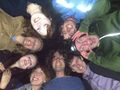
All eight of us looking down at the hash.
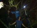
The men of the group up a tree.
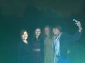
Alex, Matthea, Claire and Aimee looking beautiful at the hash.
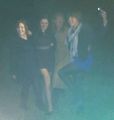
Geohashing in high heels?


Achievements
Aimee, Alex M, Matthea and Claire earned the Formal attire achievement
|
Stevage, Talex, Lachie and Cam earned the Bicycle geohash achievement
|