Difference between revisions of "2013-05-29 55 37"
imported>Vb (Created page with "{{subst:Expedition |lat = 55 |lon = 37 |date = 2013-05-29 }}") |
imported>FippeBot m (Location) |
||
| (3 intermediate revisions by one other user not shown) | |||
| Line 19: | Line 19: | ||
== Location == | == Location == | ||
<!-- where you've surveyed the hash to be --> | <!-- where you've surveyed the hash to be --> | ||
| + | In [http://ru.wikipedia.org/wiki/%D0%9F%D0%BE%D1%81%D1%91%D0%BB%D0%BE%D0%BA_%D0%B8%D0%BC%D0%B5%D0%BD%D0%B8_%D0%9B%D0%B0%D1%80%D0%B8%D0%BD%D0%B0 Poselok im. Larina], Lianozovo District. Near Lianozovo forest-park. | ||
== Participants == | == Participants == | ||
<!-- who attended: If you link to your wiki user name in this section, your expedition will be picked up by the various statistics generated for geohashing. You may use three tildes ~ as a shortcut to automatically insert the user signature of the account you are editing with. | <!-- who attended: If you link to your wiki user name in this section, your expedition will be picked up by the various statistics generated for geohashing. You may use three tildes ~ as a shortcut to automatically insert the user signature of the account you are editing with. | ||
--> | --> | ||
| + | [[User:Vb | vb]] | ||
== Plans == | == Plans == | ||
<!-- what were the original plans --> | <!-- what were the original plans --> | ||
| + | Again, the question of Google maps vs (low) precision of smartphone's GPS in the city. | ||
| + | |||
| + | Google's map shows hash in someone's private yard, surrounded by concrete fence. However, the accuracy of the map AFAIK is not known. Precision of "meters per pixel" kind is obvious and impressive, but the whole picture could be shifted in some direction. I googled'd it a bit, and talked to GIS specialist at work - the answer was the same: accuracy is generally not known, and may significantly vary from place to place. | ||
| + | |||
| + | For this case it means that the hash could be actually not in the yard, but about 10 meters away on the road. | ||
| + | |||
| + | Still. The area of the roads is relatively small compared to the area of private property around the hash. Most probably the exact coordinates are in "no public access" zone. Wouldn't be then saying "coordinates reached" based on 15m accuracy provided by GPS a cheating? I say "no" - because otherwise it wouldn't be fun ) | ||
== Expedition == | == Expedition == | ||
<!-- how it all turned out. your narrative goes here. --> | <!-- how it all turned out. your narrative goes here. --> | ||
| − | + | From Savelovskiy railway terminal on suburban train to "Lianozovo" station. From there walked trough the forest-park to the ponds, near which the park borders the poselok. | |
| − | + | ||
| + | Poselok turned out to be fenced from the rest of the city, but then it turned out that pedestrians and cyclists were allowed in without restriction, so I was able to approach the hash within GPS precision. Still I felt like I was trespassing - very uncomfortable. | ||
| + | |||
| + | Walked back trough the park to "Altufievo" metro station. | ||
| + | |||
| + | |||
| + | Radio Yerevan for formal wear geohash achievement - firstly, I didn'n wear a tie (though I never wear them, still...); secondly, didn't score any decent photos of myself at the hash (was tired after a long day). | ||
== Photos == | == Photos == | ||
| Line 38: | Line 53: | ||
--> | --> | ||
<gallery perrow="5"> | <gallery perrow="5"> | ||
| + | Image:2013-05-29 55 37 29052013853.jpg | coordinates reached | ||
| + | Image:2013-05-29 55 37 P1000939.jpg | ||
</gallery> | </gallery> | ||
| Line 43: | Line 60: | ||
{{#vardefine:ribbonwidth|800px}} | {{#vardefine:ribbonwidth|800px}} | ||
<!-- Add any achievement ribbons you earned below, or remove this section --> | <!-- Add any achievement ribbons you earned below, or remove this section --> | ||
| + | {{Radio Yerevan | ||
| + | | achievement = Formal attire achievement | ||
| + | | detail = he didn't wear a tie | ||
| + | | date = 2013-05-29 | ||
| + | | latitude = 55 | ||
| + | | longitude = 37 | ||
| + | | user = Vb | ||
| + | | image = 2013-05-29 55 37 29052013854.jpg | ||
| + | }} | ||
| − | |||
| − | |||
| − | |||
| − | |||
| − | |||
| − | |||
| − | |||
| − | |||
| − | |||
| − | |||
| − | |||
[[Category:Expeditions]] | [[Category:Expeditions]] | ||
| − | |||
[[Category:Expeditions with photos]] | [[Category:Expeditions with photos]] | ||
| − | |||
| − | |||
| − | |||
| − | |||
| − | |||
[[Category:Coordinates reached]] | [[Category:Coordinates reached]] | ||
| − | + | [[Category:Land geohash achievement]] | |
| − | + | [[Category:Public transport geohash achievement]] | |
| − | + | [[Category:Radio Yerevan]] | |
| − | [[Category: | + | {{location|RU|MOW}} |
| − | |||
| − | |||
| − | [[Category: | ||
| − | |||
| − | |||
| − | [[Category: | ||
| − | |||
| − | |||
| − | |||
| − | |||
| − | |||
| − | |||
| − | |||
| − | |||
Latest revision as of 02:37, 14 August 2019
| Wed 29 May 2013 in 55,37: 55.9010340, 37.5600973 geohashing.info google osm bing/os kml crox |
Location
In Poselok im. Larina, Lianozovo District. Near Lianozovo forest-park.
Participants
Plans
Again, the question of Google maps vs (low) precision of smartphone's GPS in the city.
Google's map shows hash in someone's private yard, surrounded by concrete fence. However, the accuracy of the map AFAIK is not known. Precision of "meters per pixel" kind is obvious and impressive, but the whole picture could be shifted in some direction. I googled'd it a bit, and talked to GIS specialist at work - the answer was the same: accuracy is generally not known, and may significantly vary from place to place.
For this case it means that the hash could be actually not in the yard, but about 10 meters away on the road.
Still. The area of the roads is relatively small compared to the area of private property around the hash. Most probably the exact coordinates are in "no public access" zone. Wouldn't be then saying "coordinates reached" based on 15m accuracy provided by GPS a cheating? I say "no" - because otherwise it wouldn't be fun )
Expedition
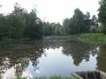
From Savelovskiy railway terminal on suburban train to "Lianozovo" station. From there walked trough the forest-park to the ponds, near which the park borders the poselok.
Poselok turned out to be fenced from the rest of the city, but then it turned out that pedestrians and cyclists were allowed in without restriction, so I was able to approach the hash within GPS precision. Still I felt like I was trespassing - very uncomfortable.
Walked back trough the park to "Altufievo" metro station.
Radio Yerevan for formal wear geohash achievement - firstly, I didn'n wear a tie (though I never wear them, still...); secondly, didn't score any decent photos of myself at the hash (was tired after a long day).
Photos

coordinates reached


Achievements
Is it true that Vb earned the Formal attire achievement?
|