Difference between revisions of "2013-06-21 41 -88"
From Geohashing
imported>EvilUncleNomo (An expedition message sent via Geohash Droid for Android.) |
imported>FippeBot m (Location) |
||
| (7 intermediate revisions by 2 users not shown) | |||
| Line 30: | Line 30: | ||
<!-- how it all turned out. your narrative goes here. --> | <!-- how it all turned out. your narrative goes here. --> | ||
| + | |||
| + | *By railroad tracks in Lisle. -- [[User:EvilUncleNomo|-- Evil Uncle Nomo]] ([[User talk:EvilUncleNomo|talk]]) 19:05, 21 June 2013 (EDT) | ||
== Tracklog == | == Tracklog == | ||
<!-- if your GPS device keeps a log, you may post a link here --> | <!-- if your GPS device keeps a log, you may post a link here --> | ||
| Line 38: | Line 40: | ||
--> | --> | ||
<gallery perrow="5"> | <gallery perrow="5"> | ||
| + | |||
| + | Image:2013-06-21_41_-88_18-09-35-631.jpg | Thwarted by the Lisle Park District. [http://www.openstreetmap.org/?lat=41.79571730&lon=-88.08378618&zoom=16&layers=B000FTF @41.7957,-88.0838] | ||
| + | |||
| + | Image:2013-06-21_41_-88_18-15-39-720.jpg | Art under the train tracks. [http://www.openstreetmap.org/?lat=41.79661790&lon=-88.08044973&zoom=16&layers=B000FTF @41.7966,-88.0804] | ||
| + | |||
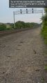
| + | Image:2013-06-21_41_-88_18-30-01-913.jpg | As close as I can get. [http://www.openstreetmap.org/?lat=41.79595257&lon=-88.08373753&zoom=16&layers=B000FTF @41.7960,-88.0837] | ||
| + | |||
| + | Image:2013-06-21_41_-88_18-31-35-777.jpg | Choo choo. [http://www.openstreetmap.org/?lat=41.79596622&lon=-88.08378000&zoom=16&layers=B000FTF @41.7960,-88.0838] | ||
| + | |||
| + | Image:2013-06-21_41_-88_18-33-39-044.jpg | Bunny by the tracks. [http://www.openstreetmap.org/?lat=41.79596082&lon=-88.08379997&zoom=16&layers=B000FTF @41.7960,-88.0838] | ||
</gallery> | </gallery> | ||
| Line 44: | Line 56: | ||
<!-- Add any achievement ribbons you earned below, or remove this section --> | <!-- Add any achievement ribbons you earned below, or remove this section --> | ||
| − | |||
| − | |||
| − | |||
| − | |||
| − | |||
| − | |||
| − | |||
| − | |||
| − | |||
| − | |||
| − | |||
[[Category:Expeditions]] | [[Category:Expeditions]] | ||
| − | |||
[[Category:Expeditions with photos]] | [[Category:Expeditions with photos]] | ||
| − | |||
| − | |||
| − | |||
| − | |||
| − | |||
| − | |||
| − | |||
| − | |||
| − | |||
[[Category:Coordinates not reached]] | [[Category:Coordinates not reached]] | ||
| − | |||
| − | |||
| − | |||
| − | |||
| − | |||
[[Category:Not reached - No public access]] | [[Category:Not reached - No public access]] | ||
| − | + | {{location|US|IL|DU}} | |
| − | |||
| − | |||
| − | |||
| − | |||
| − | |||
| − | |||
| − | |||
Latest revision as of 02:54, 14 August 2019
| Fri 21 Jun 2013 in 41,-88: 41.7959831, -88.0838456 geohashing.info google osm bing/os kml crox |
Location
Participants
Plans
Expedition
- By railroad tracks in Lisle. -- -- Evil Uncle Nomo (talk) 19:05, 21 June 2013 (EDT)
Tracklog
Photos
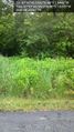
Thwarted by the Lisle Park District. @41.7957,-88.0838
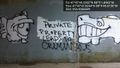
Art under the train tracks. @41.7966,-88.0804

As close as I can get. @41.7960,-88.0837
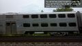
Choo choo. @41.7960,-88.0838
Bunny by the tracks. @41.7960,-88.0838


