Difference between revisions of "2013-06-26 52 20"
From Geohashing
imported>Ziemek (Created page with " <!-- If you did not specify these parameters in the template, please substitute appropriate values for IMAGE, LAT, LON, and DATE (YYYY-MM-DD format) Image:{{{image|IMAGE}...") |
imported>FippeBot m (Location) |
||
| (One intermediate revision by one other user not shown) | |||
| Line 32: | Line 32: | ||
== Expedition == | == Expedition == | ||
<!-- how it all turned out. your narrative goes here. --> | <!-- how it all turned out. your narrative goes here. --> | ||
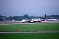
| − | The day was cloudy and rainy. GPS accuracy was low, so we were performing a traditional GPS dance for about 30 minutes. But finally we found our spot. After all this trouble we went on a embankment near the Okęcie airport to watch some departing and landing planes. | + | The day was cloudy and rainy. GPS accuracy was low, so we were performing a traditional GPS dance for about 30 minutes. But finally we found our spot. After launching few paper boats and all this trouble we went on a embankment near the Okęcie airport to watch some departing and landing planes. |
== Photos == | == Photos == | ||
| Line 39: | Line 39: | ||
--> | --> | ||
<gallery perrow="5"> | <gallery perrow="5"> | ||
| − | Image: | + | Image:260613NorillAndHisPaperBoat.JPG | Norill and his paper boat. Is launching a paper boat at the hash is an achievement? |
| − | Image: | + | Image:260613NorillPerformingAGPSDance.JPG | Norill looking for the best coordinates accuracy. |
| + | Image:260613NorillStillLookingForAnAccuracy.JPG | Norill is still searching for the best spot! | ||
| + | Image:260613StupidWindyGrins.JPG | StupidWindyGrins™ | ||
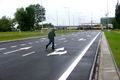
| + | Image:260613TheBestCoordinates.JPG | The Best Coordinates We Could Possibly Get | ||
| + | Image:260613RyanAirDeparting.JPG | RyaAaa! | ||
| + | Image:260613PlaneLanding.JPG | Plane landing at Okęcie airport. | ||
</gallery> | </gallery> | ||
| Line 51: | Line 56: | ||
| date = 2013-06-26 | | date = 2013-06-26 | ||
| name = Norill and Ziemek | | name = Norill and Ziemek | ||
| − | | image = | + | | image = 260613TheBestCoordinates.JPG |
}} | }} | ||
| Line 58: | Line 63: | ||
[[Category:Coordinates reached]] | [[Category:Coordinates reached]] | ||
| + | {{location|PL|W|A}} | ||
Latest revision as of 02:58, 14 August 2019
| Wed 26 Jun 2013 in 52,20: 52.1687441, 20.9817953 geohashing.info google osm bing/os kml crox |
Location
A lawn between two streets near the Chopin Airport (Okęcie).
Participants
Plans
- 2013-06-25, 16:05 - Norill noticed Ziemek (again), that the hash at the next day is in Warsaw, 10 km from Norill's apartment. There are few worries, but the adventure is scheduled!
Expedition
The day was cloudy and rainy. GPS accuracy was low, so we were performing a traditional GPS dance for about 30 minutes. But finally we found our spot. After launching few paper boats and all this trouble we went on a embankment near the Okęcie airport to watch some departing and landing planes.
Photos

Norill and his paper boat. Is launching a paper boat at the hash is an achievement?
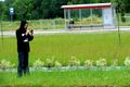
Norill looking for the best coordinates accuracy.
Norill is still searching for the best spot!

StupidWindyGrins™
The Best Coordinates We Could Possibly Get
RyaAaa!
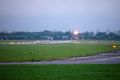
Plane landing at Okęcie airport.


Achievements
Norill and Ziemek earned the Land geohash achievement
|