Difference between revisions of "2013-06-30 33 -117"
imported>Scerruti ([live picture] In this picture I am standing on the manhole cover just below my position indicator. This implies that I did previously find the hash point. [http://www.openstreetmap.org/?lat=33.22658049&lon=-117.28704169&zoom=16&layers=B000FTF @33.2266...) |
imported>FippeBot m (Location) |
||
| (15 intermediate revisions by 2 users not shown) | |||
| Line 1: | Line 1: | ||
| − | |||
| − | |||
| − | |||
| − | |||
| − | |||
| − | |||
| − | |||
| − | |||
| − | |||
| − | |||
{{meetup graticule | {{meetup graticule | ||
| lat=33 | | lat=33 | ||
| Line 15: | Line 5: | ||
}} | }} | ||
| − | |||
__NOTOC__ | __NOTOC__ | ||
== Location == | == Location == | ||
| Line 21: | Line 10: | ||
== Participants == | == Participants == | ||
| + | [[User:RedHatter|RedHatter]] ([[User talk:RedHatter|talk]]) | ||
| + | |||
[[User:Scerruti|Stephen Cerruti]] ([[User talk:Scerruti|talk]]) | [[User:Scerruti|Stephen Cerruti]] ([[User talk:Scerruti|talk]]) | ||
| Line 27: | Line 18: | ||
== Expedition == | == Expedition == | ||
| − | + | ||
| + | === RedHatter === | ||
| + | Nothing special about this one. Got home from church and noticed the geohash for today was 10 minutes away. I proceeded to jump in the car and plant my marker. Congrats to [[User:Scerruti|Scerruti]] for bicycling and tron achevments. -- [[User:RedHatter|RedHatter]] ([[User talk:RedHatter|talk]]) [https://maps.google.com/maps?q=33.226663+-117.286759&ll=33.227596,-117.286777&spn=0.020642,0.039482&client=ubuntu&channel=fs&oe=utf-8&hnear=0x80dc71209782f0d7:0x7d7ca2bb5e44d4a2,33.226663+-117.286759&gl=us&t=m&z=15&iwloc=A @33.2267,-117.2867] 3:20ish, 30 June 2013 | ||
| + | |||
| + | === Scerruti === | ||
| + | *Made it! -- [[User:Scerruti|Stephen Cerruti]] ([[User talk:Scerruti|talk]]) [http://www.openstreetmap.org/?lat=33.22666012&lon=-117.28674045&zoom=16&layers=B000FTF @33.2267,-117.2867] 10:32, 30 June 2013 (EDT) | ||
| + | |||
| + | This hash point appeared to be trivial to meet, this expedition was focused on achieving two goals. It also marked a return to Geohashing following a fairly long hiatus. In addition, this trip marked a return to my bicycle for the first time since fall. I have been struggling with some knee issues so it was to prove interesting. | ||
| + | |||
| + | <b>Bicycling Geohash</b> | ||
| + | |||
| + | The first of my two goals was the [[Bicycle geohash achievement]]. The hash was well within distance for my rides last fall so I felt comfortable believing that I could accomplish this. Unfortunately my knees were not on board with the plan and I ended up walking a couple of key hills. However, no other modes of vehicular transportation were used. <strike>therefore I feel comfortable claiming this achievement.</strike> ([[Bicycle Geohashes]] tells me that the whole distance must be on a bike to earn the achievement.) I will post some statistics on the ride once I have edited and parsed the track log. <font color=red>FAILED - did not ride bike whole journey</font> | ||
| + | |||
| + | <b>Tron</b> | ||
| + | |||
| + | My second goal was the [[Tron achievement]]. This goal may not have been met. There are two separate events that need to be considered. I set out from my home with a mental map of my ride to accomplish the achievement. This involved a hill climb early on that told me I may need to cut one hill off my route. The original route would have taken me from Old Grove, across College to Avenida de la Plata. I knew that I would be better off eliminating the second hill, between Mesa and College on Old Grove, but I also knew that I couldn't go straight on Mesa to Avenida de la Plata without crossing my path later or making a short ride a long one. My map reminded me that I could cut through the YMCA parking lot without risking my small loop. That is where my first event occurred. While in the YMCA parking lot I remembered that there were a couple of Ingress portals that could be flipped. By the time my scanner was up I had passed the first. I circled back to it possibly crossing my path. While at the hash point my GPS was giving a really bad result. Feeling it was better to give up the tron achievement and be certain I reached the point I backtracked and rode through a dead-end neighborhood. I was able to confirm that I had achieved the hash point originally and upon my return to the point achieved a good reading from my GPS. The lesson I learned here is to be patient at the hash point to give the GPS a chance to self correct and to trust the Google Maps representation of the hash point location. <font color=red>FAILED - crossed path for Ingress and at hash point</font> | ||
| + | |||
| + | |||
| + | I continued home from the hash point without incident, it was almost all downhill. Avendia de la Plata has a great overlook spot and after pausing for a photo I managed to reach 30 MPH. A good speed for an old guy like me. | ||
| + | |||
| + | * Bike Ride: Achieved | ||
| + | * Hash Point: Achieved | ||
| + | * Ingress Portals Flipped: 2 | ||
| + | * Stop to Admire View: Achieved | ||
| + | * Advil and Ice Pack: Achieved | ||
| + | * Maximum Speed: 30 MPH | ||
== Tracklog == | == Tracklog == | ||
| − | < | + | [https://docs.google.com/file/d/0B2uBOD8EcgrfenhtM0tjMjg4bWs/edit?usp=sharing| Raw Track Log]<br /> |
| + | [[File:Track Image 2013-06-30 33 -117.jpg]] | ||
== Photos == | == Photos == | ||
| − | |||
| − | |||
| − | |||
<gallery perrow="5"> | <gallery perrow="5"> | ||
| Line 43: | Line 57: | ||
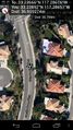
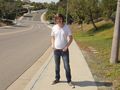
Image:2013-06-30_33_-117_07-28-59-261.jpg | In this picture I am standing on the manhole cover just below my position indicator. This implies that I did previously find the hash point. [http://www.openstreetmap.org/?lat=33.22658049&lon=-117.28704169&zoom=16&layers=B000FTF @33.2266,-117.2870] | Image:2013-06-30_33_-117_07-28-59-261.jpg | In this picture I am standing on the manhole cover just below my position indicator. This implies that I did previously find the hash point. [http://www.openstreetmap.org/?lat=33.22658049&lon=-117.28704169&zoom=16&layers=B000FTF @33.2266,-117.2870] | ||
| + | |||
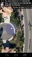
| + | Image:2013-06-30_33_-117_07-33-03-542.jpg | That's better. [http://www.openstreetmap.org/?lat=33.22665882&lon=-117.28677892&zoom=16&layers=B000FTF @33.2267,-117.2868] | ||
| + | |||
| + | Image:2013-06-30_33_-117_07-40-17-393.jpg | Gratuitous panoramic image from near hash point. [http://www.openstreetmap.org/?lat=33.23090610&lon=-117.28461413&zoom=16&layers=B000FTF @33.2309,-117.2846] | ||
| + | |||
| + | Image:2013-06-30_33_-117_redhatter_marker.jpg | The internet was here! | ||
| + | |||
| + | Image:2013-06-30_33_-117_redhatter_grin.jpg | Stupid Grin™ | ||
| + | |||
| + | Image:2013-06-30_33_-117_redhatter_proof.jpg | This is there, and here I am. | ||
</gallery> | </gallery> | ||
== Achievements == | == Achievements == | ||
{{#vardefine:ribbonwidth|800px}} | {{#vardefine:ribbonwidth|800px}} | ||
| − | |||
| − | |||
| − | |||
[[Category:Expeditions]] | [[Category:Expeditions]] | ||
| − | |||
[[Category:Expeditions with photos]] | [[Category:Expeditions with photos]] | ||
| − | + | ||
| − | |||
| − | |||
| − | |||
| − | |||
[[Category:Coordinates reached]] | [[Category:Coordinates reached]] | ||
| − | + | {{location|US|CA|SD}} | |
| − | |||
| − | |||
| − | |||
| − | |||
| − | |||
| − | |||
| − | |||
| − | |||
| − | |||
| − | |||
| − | |||
| − | |||
| − | |||
| − | |||
| − | |||
| − | |||
| − | |||
Latest revision as of 03:00, 14 August 2019
| Sun 30 Jun 2013 in 33,-117: 33.2266635, -117.2867590 geohashing.info google osm bing/os kml crox |
Location
In the middle of Avenida de la Plata, just off Mesa Drive, in the Rancho del Oro neighborhood of Oceanside, CA.
Participants
Plans
This hash is ideal for a drive-bySpeed Racer or first land geohash achievement. I am hoping to earn the round tripTron and Bicycle Geohash achievements. I will be starting near College and Frazee but I plan to go early to beat the heat. Stephen Cerruti (talk)
Expedition
RedHatter
Nothing special about this one. Got home from church and noticed the geohash for today was 10 minutes away. I proceeded to jump in the car and plant my marker. Congrats to Scerruti for bicycling and tron achevments. -- RedHatter (talk) @33.2267,-117.2867 3:20ish, 30 June 2013
Scerruti
- Made it! -- Stephen Cerruti (talk) @33.2267,-117.2867 10:32, 30 June 2013 (EDT)
This hash point appeared to be trivial to meet, this expedition was focused on achieving two goals. It also marked a return to Geohashing following a fairly long hiatus. In addition, this trip marked a return to my bicycle for the first time since fall. I have been struggling with some knee issues so it was to prove interesting.
Bicycling Geohash
The first of my two goals was the Bicycle geohash achievement. The hash was well within distance for my rides last fall so I felt comfortable believing that I could accomplish this. Unfortunately my knees were not on board with the plan and I ended up walking a couple of key hills. However, no other modes of vehicular transportation were used. therefore I feel comfortable claiming this achievement. (Bicycle Geohashes tells me that the whole distance must be on a bike to earn the achievement.) I will post some statistics on the ride once I have edited and parsed the track log. FAILED - did not ride bike whole journey
Tron
My second goal was the Tron achievement. This goal may not have been met. There are two separate events that need to be considered. I set out from my home with a mental map of my ride to accomplish the achievement. This involved a hill climb early on that told me I may need to cut one hill off my route. The original route would have taken me from Old Grove, across College to Avenida de la Plata. I knew that I would be better off eliminating the second hill, between Mesa and College on Old Grove, but I also knew that I couldn't go straight on Mesa to Avenida de la Plata without crossing my path later or making a short ride a long one. My map reminded me that I could cut through the YMCA parking lot without risking my small loop. That is where my first event occurred. While in the YMCA parking lot I remembered that there were a couple of Ingress portals that could be flipped. By the time my scanner was up I had passed the first. I circled back to it possibly crossing my path. While at the hash point my GPS was giving a really bad result. Feeling it was better to give up the tron achievement and be certain I reached the point I backtracked and rode through a dead-end neighborhood. I was able to confirm that I had achieved the hash point originally and upon my return to the point achieved a good reading from my GPS. The lesson I learned here is to be patient at the hash point to give the GPS a chance to self correct and to trust the Google Maps representation of the hash point location. FAILED - crossed path for Ingress and at hash point
I continued home from the hash point without incident, it was almost all downhill. Avendia de la Plata has a great overlook spot and after pausing for a photo I managed to reach 30 MPH. A good speed for an old guy like me.
- Bike Ride: Achieved
- Hash Point: Achieved
- Ingress Portals Flipped: 2
- Stop to Admire View: Achieved
- Advil and Ice Pack: Achieved
- Maximum Speed: 30 MPH
Tracklog

Photos

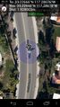
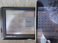
I'm in the middle of the road. This is where Google maps and earth show the hash point to be yet my GPS shows me off in the bushes. I am going to need to figure out which is in error. @33.2268,-117.2870
This is a screenshot with me standing where the flag is stuck. @33.2269,-117.2865
In this picture I am standing on the manhole cover just below my position indicator. This implies that I did previously find the hash point. @33.2266,-117.2870
That's better. @33.2267,-117.2868
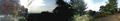
Gratuitous panoramic image from near hash point. @33.2309,-117.2846
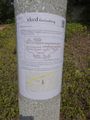
The internet was here!
Stupid Grin™
This is there, and here I am.


