Difference between revisions of "2013-07-02 31 -97"
From Geohashing
imported>Neimster |
imported>FippeBot m (Location) |
||
| (8 intermediate revisions by 2 users not shown) | |||
| Line 1: | Line 1: | ||
| − | |||
| − | |||
| − | |||
| − | |||
| − | |||
| − | |||
| − | |||
| − | |||
| − | |||
{{meetup graticule | {{meetup graticule | ||
| lat=31 | | lat=31 | ||
| Line 15: | Line 6: | ||
}} | }} | ||
| − | |||
__NOTOC__ | __NOTOC__ | ||
== Location == | == Location == | ||
| − | + | Another cow pasture (of course, it's Texas) just north of Waco | |
== Participants == | == Participants == | ||
| − | + | *Neiman ([[User:Neimster|Neimster]]) | |
| − | + | *Ellen ([[User:Gerti|Gerti]]) | |
== Plans == | == Plans == | ||
| − | + | We planned as before, set the date and then waited for the hash to appear like eager little homing pigeons. | |
== Expedition == | == Expedition == | ||
<!-- how it all turned out. your narrative goes here. --> | <!-- how it all turned out. your narrative goes here. --> | ||
| − | |||
| − | |||
| − | |||
== Photos == | == Photos == | ||
| − | <!-- | + | <!-- ELLEN! Feel free to change these descriptions, or re-order the photos, or whatever. --> |
| − | |||
| − | --> | ||
<gallery perrow="5"> | <gallery perrow="5"> | ||
| + | Image:2013-07-02 31 -97 proof.png | Success! | ||
| + | Image:2013-07-02 31 -97 picnic.jpg | We had a picnic. | ||
| + | Image:2013-07-02 31 -97 panorama.jpg | Panorama looking southward from the hashpoint over the nearby pond. | ||
| + | Image:2013-07-02 31 -97 faces.jpg | Fun times were had. | ||
| + | Image:2013-07-02 31 -97 drivenorth.jpg | Taken about halfway from the road to the barn near the hash, facing towards the road. | ||
| + | Image:2013-07-02 31 -97 drivesouth.jpg | The same location as the previous picture, but facing the opposite direction. | ||
</gallery> | </gallery> | ||
== Achievements == | == Achievements == | ||
{{#vardefine:ribbonwidth|800px}} | {{#vardefine:ribbonwidth|800px}} | ||
| − | + | {{Picnic_geohash | |
| − | + | | latitude = 31 | |
| + | | longitude = -97 | ||
| + | | date = 2013-07-02 | ||
| + | | name = [[User:Gerti|Ellen]] and [[User:Neimster|Neiman]] | ||
| + | | image = 2013-07-02 31 -97 picnic.jpg | ||
| + | | food = turkey sandwiches | ||
| + | }} | ||
[[Category:Expeditions]] | [[Category:Expeditions]] | ||
[[Category:Expeditions with photos]] | [[Category:Expeditions with photos]] | ||
[[Category:Coordinates reached]] | [[Category:Coordinates reached]] | ||
| + | {{location|US|TX|ML}} | ||
Latest revision as of 06:10, 6 August 2019
| Tue 2 Jul 2013 in 31,-97: 31.7930551, -97.0274672 geohashing.info google osm bing/os kml crox |
Location
Another cow pasture (of course, it's Texas) just north of Waco
Participants
Plans
We planned as before, set the date and then waited for the hash to appear like eager little homing pigeons.
Expedition
Photos
Success!
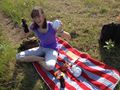
We had a picnic.
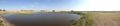
Panorama looking southward from the hashpoint over the nearby pond.
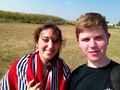
Fun times were had.
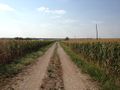
Taken about halfway from the road to the barn near the hash, facing towards the road.
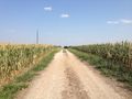
The same location as the previous picture, but facing the opposite direction.


Achievements
Ellen and Neiman earned the Picnic achievement
|