Difference between revisions of "2013-07-07 39 -76"
imported>OfficeLinebacker ([live picture] That's the exact spot) |
m (→Photos) |
||
| (15 intermediate revisions by 4 users not shown) | |||
| Line 19: | Line 19: | ||
== Location == | == Location == | ||
<!-- where you've surveyed the hash to be --> | <!-- where you've surveyed the hash to be --> | ||
| + | On a corner in Point Pleasant, MD, close to Marley Creek | ||
== Participants == | == Participants == | ||
<!-- who attended: If you link to your wiki user name in this section, your expedition will be picked up by the various statistics generated for geohashing. You may use three tildes ~ as a shortcut to automatically insert the user signature of the account you are editing with. | <!-- who attended: If you link to your wiki user name in this section, your expedition will be picked up by the various statistics generated for geohashing. You may use three tildes ~ as a shortcut to automatically insert the user signature of the account you are editing with. | ||
--> | --> | ||
| + | *Allison | ||
| + | *[[User:OfficeLinebacker|OfficeLinebacker]] ([[User talk:OfficeLinebacker|talk]]) | ||
== Plans == | == Plans == | ||
<!-- what were the original plans --> | <!-- what were the original plans --> | ||
| + | To drive there, get the hash, then explore a bit | ||
== Expedition == | == Expedition == | ||
<!-- how it all turned out. your narrative goes here. --> | <!-- how it all turned out. your narrative goes here. --> | ||
| + | We thought there was a sidewalk there but there wasn't. We pulled over onto Hilltop and when we parked, outside of a fence but on the same grassy area as some equipment, a man watering plants inside the fen e gave us the evil eye. I asked if this was his property and the fact that i asked made him lighten up and he waved dismissively. We proceeded to the hash point (the has point itself was not on private property, just the verge where we pulled over. | ||
| + | |||
| + | We proceeded to the has point and took our pics without incident. After that we went to a place that I hoped would allow us to overlook the creek. Well my hopes were exceeded and there was a small path to a tiny little beach. Allison, having missed out on getting in the water on [[2013-07-06 39 -77|yesterday's expedition]], decided to go for a wade. The ground was nice, soft sand and much better suited to wading than yesterday's water area. We waded and took some pics. We saw a huge heron and waved to a few passing boaters. Marley Creek is popular with folks with powerful speedboats because it's the only fresh water in the area with no speed limit. | ||
| − | |||
== Tracklog == | == Tracklog == | ||
<!-- if your GPS device keeps a log, you may post a link here --> | <!-- if your GPS device keeps a log, you may post a link here --> | ||
| Line 44: | Line 50: | ||
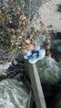
Image:2013-07-07_39_-76_11-54-59-909.jpg | That's the exact spot | Image:2013-07-07_39_-76_11-54-59-909.jpg | That's the exact spot | ||
| + | |||
| + | Image:2013-07-07_39_-76_12-01-46-719.jpg | The famous Marley Creek | ||
| + | |||
| + | File:2013-07-07_39_-76_12-06-32-324.jpg | Allison wading in Marley Creek | ||
| + | |||
| + | Image:2013-07-07_39_-76_12-11-54-922.jpg | Dipping the toes in the water | ||
| + | |||
| + | Image:2013-07-07_39_-76_12-21-42-105.jpg | Shoes safe and dry | ||
| + | |||
</gallery> | </gallery> | ||
| Line 51: | Line 66: | ||
| − | |||
| − | |||
| − | |||
| − | |||
| − | |||
| − | |||
| − | |||
| − | |||
| − | |||
[[Category:Expeditions]] | [[Category:Expeditions]] | ||
| − | |||
[[Category:Expeditions with photos]] | [[Category:Expeditions with photos]] | ||
| − | |||
| − | |||
| − | |||
| − | |||
| − | |||
[[Category:Coordinates reached]] | [[Category:Coordinates reached]] | ||
| − | + | {{location|US|MD|AN}} | |
| − | |||
| − | |||
| − | |||
| − | |||
| − | |||
| − | |||
| − | |||
| − | |||
| − | |||
| − | |||
| − | |||
| − | |||
| − | |||
| − | |||
| − | |||
| − | |||
| − | |||
Latest revision as of 07:59, 23 June 2020
| Sun 7 Jul 2013 in 39,-76: 39.1754668, -76.5963789 geohashing.info google osm bing/os kml crox |
Location
On a corner in Point Pleasant, MD, close to Marley Creek
Participants
- Allison
- OfficeLinebacker (talk)
Plans
To drive there, get the hash, then explore a bit
Expedition
We thought there was a sidewalk there but there wasn't. We pulled over onto Hilltop and when we parked, outside of a fence but on the same grassy area as some equipment, a man watering plants inside the fen e gave us the evil eye. I asked if this was his property and the fact that i asked made him lighten up and he waved dismissively. We proceeded to the hash point (the has point itself was not on private property, just the verge where we pulled over.
We proceeded to the has point and took our pics without incident. After that we went to a place that I hoped would allow us to overlook the creek. Well my hopes were exceeded and there was a small path to a tiny little beach. Allison, having missed out on getting in the water on yesterday's expedition, decided to go for a wade. The ground was nice, soft sand and much better suited to wading than yesterday's water area. We waded and took some pics. We saw a huge heron and waved to a few passing boaters. Marley Creek is popular with folks with powerful speedboats because it's the only fresh water in the area with no speed limit.
Tracklog
Photos

Made it" @39.1754,-76.5964
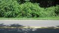
That's the exact spot
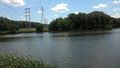
The famous Marley Creek
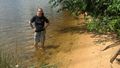
Allison wading in Marley Creek
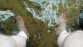
Dipping the toes in the water
Shoes safe and dry


