Difference between revisions of "2013-07-07 47 -122"
From Geohashing
imported>Thomcat (Steilacoom expedition) |
imported>Thomcat ([live picture] Approaching spot [http://www.openstreetmap.org/?lat=47.17600617&lon=-122.59288177&zoom=16&layers=B000FTF @47.1760,-122.5929]) |
||
| Line 28: | Line 28: | ||
--> | --> | ||
<gallery perrow="5"> | <gallery perrow="5"> | ||
| + | |||
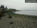
| + | Image:2013-07-07_47_-122_11-26-58-755.jpg | Approaching spot [http://www.openstreetmap.org/?lat=47.17600617&lon=-122.59288177&zoom=16&layers=B000FTF @47.1760,-122.5929] | ||
</gallery> | </gallery> | ||
Revision as of 18:27, 7 July 2013
| Sun 7 Jul 2013 in Seattle: 47.1754668, -122.5963789 geohashing.info google osm bing/os kml crox |
Location
On the beach in Steilacoom, just south of Sunnyside Beach park.
Participants
Plans
Expedition at low tide, which is 11:53 AM today. Also visit the park and a nearby off-leash dog park.
Expedition
Tracklog
Photos
Approaching spot @47.1760,-122.5929

Achievements