Difference between revisions of "2013-07-12 55 12"
From Geohashing
imported>Svesterli (→Achievements) |
imported>Jiml m (Adjust result codes) |
||
| Line 15: | Line 15: | ||
}} | }} | ||
| − | + | ||
__NOTOC__ | __NOTOC__ | ||
== Location == | == Location == | ||
| − | + | ||
Edge of a collection of small garden allotments (Da: "Kolonihaver"). | Edge of a collection of small garden allotments (Da: "Kolonihaver"). | ||
== Participants == | == Participants == | ||
| − | + | ||
| − | + | * [[User:Svesterli|Svesterli]] | |
| − | [[User:Svesterli|Svesterli]] | ||
== Plans == | == Plans == | ||
| − | + | ||
To drive by on the way from from work. | To drive by on the way from from work. | ||
== Expedition == | == Expedition == | ||
| − | + | ||
Easy to find. Parked close by and walked the last part. | Easy to find. Parked close by and walked the last part. | ||
| Line 38: | Line 37: | ||
== Photos == | == Photos == | ||
| − | + | ||
| − | |||
| − | |||
<gallery perrow="5"> | <gallery perrow="5"> | ||
Image:2013-07-12 55 12 IMG_1774.jpg | The place | Image:2013-07-12 55 12 IMG_1774.jpg | The place | ||
| Line 48: | Line 45: | ||
== Achievements == | == Achievements == | ||
{{#vardefine:ribbonwidth|800px}} | {{#vardefine:ribbonwidth|800px}} | ||
| − | + | ||
{{land geohash | {{land geohash | ||
| Line 59: | Line 56: | ||
}} | }} | ||
| − | |||
| − | |||
| − | |||
| − | |||
| − | |||
| − | |||
| − | |||
| − | |||
[[Category:Expeditions]] | [[Category:Expeditions]] | ||
| − | + | ||
[[Category:Expeditions with photos]] | [[Category:Expeditions with photos]] | ||
| − | |||
| − | |||
| − | |||
| − | |||
| − | |||
[[Category:Coordinates reached]] | [[Category:Coordinates reached]] | ||
| − | |||
| − | |||
| − | |||
| − | |||
| − | |||
| − | |||
| − | |||
| − | |||
| − | |||
| − | |||
| − | |||
| − | |||
| − | |||
| − | |||
| − | |||
| − | |||
| − | |||
| − | |||
Revision as of 02:54, 13 July 2013
| Fri 12 Jul 2013 in 55,12: 55.7287979, 12.4806282 geohashing.info google osm bing/os kml crox |
Location
Edge of a collection of small garden allotments (Da: "Kolonihaver").
Participants
Plans
To drive by on the way from from work.
Expedition
Easy to find. Parked close by and walked the last part.
Tracklog
Photos
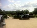
The place
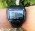
The proof


Achievements
Svesterli earned the Land geohash achievement
|