Difference between revisions of "2013-07-13 43 -116"
imported>Eldin ([live] Success! With ambassador achievement even. Pics and writeup to follow.) |
imported>Eldin (add expedition details and photos.) |
||
| Line 1: | Line 1: | ||
| − | |||
| − | |||
| − | |||
| − | |||
| − | |||
| − | |||
| − | |||
| − | |||
| − | |||
| − | |||
{{meetup graticule | {{meetup graticule | ||
| lat=43 | | lat=43 | ||
| Line 15: | Line 5: | ||
}} | }} | ||
| − | |||
__NOTOC__ | __NOTOC__ | ||
== Location == | == Location == | ||
| − | + | In or near an irrigation ditch between 2 schools and a neighborhood in Caldwell, ID. | |
== Participants == | == Participants == | ||
| − | + | [[User:Eldin|Eldin]] | |
| − | |||
| − | |||
| − | |||
| − | |||
== Expedition == | == Expedition == | ||
| − | + | Before setting out, I called Borneo to see if he was available to be dragged along, but he was unfortunately busy. So by myself, I made the drive to Caldwell. The drive took a little longer than I had expected due to having to detour around construction in several places, but it was otherwise uneventful. I arrived near the area and parked in the lot of the nearby middle school. I gathered my camera, smartphone, and geohash marker, and set out walking across the track in the schoolyard, towards the hash point. I found a gate in the fence fairly near the hash point, but a bit of investigation revealed that the actual point was on the oposite side of the irrigation ditch. So I walked about a hundred feet down the ditch to where there was a small footbridge and crossed. Although the ditch itself was not private property, I did have to cross private property in order to reach it. Fortunately, there was a man out spraying weeds in said property. I asked him if it would be ok to cross his yard and walk down along the ditch, and he told me it would be ok, but that there was a fence a couple houses down that couldn't be passed (he was assuming I wanted to go through to somewhere, I imagine). I thanked him and walked down to the ditch. I quickly ascertained that the coordinates were straight back from the corner of his house, right at the edge of the water. The man who had given me permission to cross his yard gave me a questioning look as I walked back and forth to find the exact spot, then stopped and took several pictures of my phone, myself, and the ground. As I was leaving he asked about why I was taking the pictures, and I explained to him that I was playing a game where I get points by reaching specific, randomly chosen locations. This (aproximately truthful) explanation seemed to satisfy him. I offered to give him the expedition poster I had prepared prior to setting out, but he declined. I thanked him again for allowing me to cross his yard, and wished him a good afternoon. On the way back to my car, I hung the poster in a tree beside the footbridge, about 150ft along the ditch from the hashpoint. | |
| + | I'm counting this as making 4pm Saturday meetup, since I was within sight and shouting distance of the geohash for at least 10 minutes either side of 4pm, though it was a few minutes after 4 by the time I reached the exact spot. However, as expected, nobody else showed up. | ||
*Success! With ambassador achievement even. Pics and writeup to follow. -- [[User:Eldin|Eldin]] ([[User talk:Eldin|talk]]) [http://www.openstreetmap.org/?lat=43.64683182&lon=-116.68520600&zoom=16&layers=B000FTF @43.6468,-116.6852] 16:16, 13 July 2013 (MDT) | *Success! With ambassador achievement even. Pics and writeup to follow. -- [[User:Eldin|Eldin]] ([[User talk:Eldin|talk]]) [http://www.openstreetmap.org/?lat=43.64683182&lon=-116.68520600&zoom=16&layers=B000FTF @43.6468,-116.6852] 16:16, 13 July 2013 (MDT) | ||
| − | |||
| − | |||
== Photos == | == Photos == | ||
| − | < | + | |
| − | + | <gallery> | |
| − | -- | + | File:2013-07-13 43 -116 proof.jpg | Proof that I was in the right place, at approximately the right time. |
| − | + | File:2013-07-13 43 -116 grin.jpg | Something like a stupid grin. | |
| + | File:2013-07-13 43 -116 gate.jpg | The hash point is right through there. But reaching it from this side would require wading across the ditch. The man spraying weeds with his back turned to the camera here is the kind soul who allowed me to cross his property for today's expedition. | ||
| + | File:2013-07-13 43 -116 spot.jpg | The actual hashpoint. You can't really tell from the picture, but about half of the plants you can see are growing in the water. | ||
| + | File:2013-07-13 43 -116 poster.jpg | The marker I left near the hashpoint. Anyone crossing the bridge is sure to see it, until it falls down or gets removed. | ||
</gallery> | </gallery> | ||
== Achievements == | == Achievements == | ||
{{#vardefine:ribbonwidth|800px}} | {{#vardefine:ribbonwidth|800px}} | ||
| − | + | {{land geohash | latitude = 43 | longitude = -116 | date = 2013-07-13 | name = [[User:Eldin|Eldin]]}} | |
| + | {{Ambassador geohash | latitude = 43 | longitude = -116 | date = 2013-07-13 | name = [[User:Eldin|Eldin]]}} | ||
| − | |||
| − | |||
| − | |||
| − | |||
| − | |||
| − | |||
| − | |||
| − | |||
| − | |||
| − | |||
| − | |||
[[Category:Expeditions]] | [[Category:Expeditions]] | ||
| − | |||
[[Category:Expeditions with photos]] | [[Category:Expeditions with photos]] | ||
| − | |||
| − | |||
| − | |||
| − | |||
| − | |||
[[Category:Coordinates reached]] | [[Category:Coordinates reached]] | ||
| − | |||
| − | |||
| − | |||
| − | |||
| − | |||
| − | |||
| − | |||
| − | |||
| − | |||
| − | |||
| − | |||
| − | |||
| − | |||
| − | |||
| − | |||
| − | |||
| − | |||
| − | |||
Revision as of 01:52, 16 July 2013
| Sat 13 Jul 2013 in 43,-116: 43.6464569, -116.6879201 geohashing.info google osm bing/os kml crox |
Location
In or near an irrigation ditch between 2 schools and a neighborhood in Caldwell, ID.
Participants
Expedition
Before setting out, I called Borneo to see if he was available to be dragged along, but he was unfortunately busy. So by myself, I made the drive to Caldwell. The drive took a little longer than I had expected due to having to detour around construction in several places, but it was otherwise uneventful. I arrived near the area and parked in the lot of the nearby middle school. I gathered my camera, smartphone, and geohash marker, and set out walking across the track in the schoolyard, towards the hash point. I found a gate in the fence fairly near the hash point, but a bit of investigation revealed that the actual point was on the oposite side of the irrigation ditch. So I walked about a hundred feet down the ditch to where there was a small footbridge and crossed. Although the ditch itself was not private property, I did have to cross private property in order to reach it. Fortunately, there was a man out spraying weeds in said property. I asked him if it would be ok to cross his yard and walk down along the ditch, and he told me it would be ok, but that there was a fence a couple houses down that couldn't be passed (he was assuming I wanted to go through to somewhere, I imagine). I thanked him and walked down to the ditch. I quickly ascertained that the coordinates were straight back from the corner of his house, right at the edge of the water. The man who had given me permission to cross his yard gave me a questioning look as I walked back and forth to find the exact spot, then stopped and took several pictures of my phone, myself, and the ground. As I was leaving he asked about why I was taking the pictures, and I explained to him that I was playing a game where I get points by reaching specific, randomly chosen locations. This (aproximately truthful) explanation seemed to satisfy him. I offered to give him the expedition poster I had prepared prior to setting out, but he declined. I thanked him again for allowing me to cross his yard, and wished him a good afternoon. On the way back to my car, I hung the poster in a tree beside the footbridge, about 150ft along the ditch from the hashpoint.
I'm counting this as making 4pm Saturday meetup, since I was within sight and shouting distance of the geohash for at least 10 minutes either side of 4pm, though it was a few minutes after 4 by the time I reached the exact spot. However, as expected, nobody else showed up.
- Success! With ambassador achievement even. Pics and writeup to follow. -- Eldin (talk) @43.6468,-116.6852 16:16, 13 July 2013 (MDT)
Photos
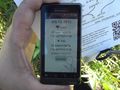
Proof that I was in the right place, at approximately the right time.

Something like a stupid grin.
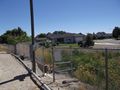
The hash point is right through there. But reaching it from this side would require wading across the ditch. The man spraying weeds with his back turned to the camera here is the kind soul who allowed me to cross his property for today's expedition.
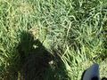
The actual hashpoint. You can't really tell from the picture, but about half of the plants you can see are growing in the water.
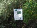
The marker I left near the hashpoint. Anyone crossing the bridge is sure to see it, until it falls down or gets removed.


Achievements
Eldin earned the Land geohash achievement
|
Eldin earned the Ambassador achievement
|