Difference between revisions of "2013-07-15 33 -117"
From Geohashing
imported>Scerruti (→Expedition) |
imported>FippeBot m (Location) |
||
| (9 intermediate revisions by 2 users not shown) | |||
| Line 1: | Line 1: | ||
| + | {{meetup graticule | lat=33 | lon=-117 | date=2013-07-15}} | ||
| − | |||
| − | |||
| − | |||
| − | |||
| − | |||
| − | |||
| − | |||
| − | |||
| − | |||
| − | |||
| − | |||
| − | |||
| − | |||
| − | |||
| − | |||
| − | |||
__NOTOC__ | __NOTOC__ | ||
== Location == | == Location == | ||
| − | On a power line | + | On a short walking trail (really just a power line access road in disguise) immediately south of Lake Poway Road in Poway, CA |
== Participants == | == Participants == | ||
| − | [[User: | + | [[User:Mathgeek|Todd Sheaman]] |
| − | [[User: | + | [[User:LucasBrown|LucasBrown]] |
== Plans == | == Plans == | ||
| − | + | Not too far from home but if I do make it today it will be later in the evening. [[User:Mathgeek| -Todd]] | |
| − | + | Just 3.25 km from my house. I'll be there at dusk. --[[User:LucasBrown|LucasBrown]] | |
== Expedition == | == Expedition == | ||
| − | + | [[User:LucasBrown|LucasBrown]] reached the hashpoint at 20:46, 15 July 2013 (PDT) | |
== Tracklog == | == Tracklog == | ||
| Line 37: | Line 22: | ||
== Photos == | == Photos == | ||
| − | |||
| − | |||
| − | |||
<gallery perrow="5"> | <gallery perrow="5"> | ||
| + | Image:2013-07-15_33_-117_21-13-48-923.jpg | ([[User:LucasBrown|LucasBrown]]) Geohash Droid details page at the hashpoint | ||
| + | Image:2013-07-15_33_-117_21-14-10-110.jpg | ([[User:LucasBrown|LucasBrown]]) Regional map at hashpoint | ||
| + | Image:2013-07-15_33_-117_21-14-30-438.jpg | ([[User:LucasBrown|LucasBrown]]) Local map at hashpoint | ||
| + | Image:2013-07-15_33_-117_21-23-30-464.jpg | ([[User:LucasBrown|LucasBrown]]) Sign posted at hashpoint | ||
| + | Image:2013-07-15_33_-117_21-24-22-747.jpg | ([[User:LucasBrown|LucasBrown]]) Enduring great pain to post the sign | ||
</gallery> | </gallery> | ||
== Achievements == | == Achievements == | ||
{{#vardefine:ribbonwidth|800px}} | {{#vardefine:ribbonwidth|800px}} | ||
| − | |||
| − | |||
| − | |||
| − | |||
[[Category:Expeditions]] | [[Category:Expeditions]] | ||
| − | |||
[[Category:Expeditions with photos]] | [[Category:Expeditions with photos]] | ||
| − | |||
| − | |||
| − | |||
| − | |||
| − | |||
[[Category:Coordinates reached]] | [[Category:Coordinates reached]] | ||
| − | + | {{location|US|CA|SD}} | |
| − | |||
| − | |||
| − | |||
| − | |||
| − | |||
| − | |||
| − | |||
| − | |||
| − | |||
| − | |||
| − | |||
| − | |||
| − | |||
| − | |||
| − | |||
| − | |||
| − | |||
Latest revision as of 03:09, 14 August 2019
| Mon 15 Jul 2013 in 33,-117: 33.0008243, -117.0324176 geohashing.info google osm bing/os kml crox |
Location
On a short walking trail (really just a power line access road in disguise) immediately south of Lake Poway Road in Poway, CA
Participants
Plans
Not too far from home but if I do make it today it will be later in the evening. -Todd
Just 3.25 km from my house. I'll be there at dusk. --LucasBrown
Expedition
LucasBrown reached the hashpoint at 20:46, 15 July 2013 (PDT)
Tracklog
Photos
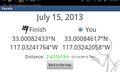
(LucasBrown) Geohash Droid details page at the hashpoint
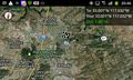
(LucasBrown) Regional map at hashpoint
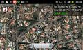
(LucasBrown) Local map at hashpoint

(LucasBrown) Sign posted at hashpoint
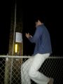
(LucasBrown) Enduring great pain to post the sign


