Difference between revisions of "2013-07-16 47 8"
imported>Chris 47 8 m |
imported>FippeBot m (Location) |
||
| (7 intermediate revisions by 2 users not shown) | |||
| Line 1: | Line 1: | ||
| − | + | [[Image:{{{image|2013-07-16_47_8_10.JPG}}}|thumb|left]] | |
| − | |||
| − | |||
| − | |||
| − | |||
| − | |||
| − | |||
| − | |||
{{meetup graticule | {{meetup graticule | ||
| lat=47 | | lat=47 | ||
| Line 15: | Line 8: | ||
}} | }} | ||
| − | + | ||
__NOTOC__ | __NOTOC__ | ||
== Location == | == Location == | ||
| − | Very close to the | + | Very close to the Rhine Falls in Schaffhausen. |
| + | |||
== Participants == | == Participants == | ||
| − | [[User:Chris_47_8|Chris_47_8]] | + | * [[User:Chris_47_8|Chris_47_8]] |
== Plans == | == Plans == | ||
| − | + | 16:21 S12 from Stadelhofen to Winterthur, from there S33 to Schloss Laufen. | |
== Expedition == | == Expedition == | ||
| − | |||
| − | + | A hash very close to the [[wikipedia:Rhine_Falls|Rhine Falls]]. Well, that's a good reason to go there. I remember i was there a long time ago, maybe as a kid, and i was very impressed at that time. I had nothing to do after work, so i went. | |
| − | <! | + | |
| + | I took a train to the Schloss Laufen (Castle Laufen) station, which lies just under the castle and | ||
| + | next to the falls. When I stepped out of the train, I heard this deep vibrant roar, which never | ||
| + | went away for the rest of the expedition. While walking to the hashpoint, I realized that I was | ||
| + | on the wrong path. Google Maps is not always very accurate, especially when the way is a | ||
| + | foot/bike path in the forest. I think the guys at Google just guess the roads by looking | ||
| + | at satellite images or so. So I took a little 1km detour, but eventually I managed to find | ||
| + | the place. Next to the spot was a nice little vineyard with young grapes, ready to suck all | ||
| + | the sunlight and turn it into sugar. The hash itself was in a maize field, and not really | ||
| + | spectacular. The spectacular thing about this expedition was just 800 meters away, and I | ||
| + | could still hear it from here. | ||
| + | |||
| + | I walked back to the castle, and from there I crossed the river Rhine on the train bridge. | ||
| + | The bridge spans the river just above the falls. I walked all around the falls on the right | ||
| + | hand side of the stream. The view and the noise was really impressive. It's not the height | ||
| + | of the falls, that's only 21 meters, but it's the amount of water that crashes down there. | ||
| + | On an average summer day, 700 m<sup>3</sup> of water pass the falls. Per second! The noise | ||
| + | of the water is just dominating the whole scenery. | ||
| + | |||
| + | On the lower end of the falls is something like a small lake, and a few restaurants around it. | ||
| + | So I decided to have a rest, and had a tasty salmon filet while enjoying the scenic view from the restaurant's terrace. | ||
| + | |||
| + | Next to the falls on the side towards Schaffhausen is an industrial area, which evolved there | ||
| + | from using water power from the falls. Some pre-industrial water wheels and mills are still | ||
| + | existing. The first aluminium factory in Europe was also located right next to the falls. | ||
| + | Several industrial companies settled here over the centuries. From the restaurant I could | ||
| + | see a very prominent one of them, SIG industries, which produce [[wikipedia:SIG_SG_550|these things]]. | ||
| + | |||
== Photos == | == Photos == | ||
| − | + | ||
| − | |||
| − | |||
<gallery perrow="5"> | <gallery perrow="5"> | ||
| + | Image:2013-07-16_47_8_02.JPG | The way to the hash. | ||
| + | Image:2013-07-16_47_8_03.JPG | A vineyard. | ||
| + | Image:2013-07-16_47_8_04.JPG | Young grapes. | ||
| + | Image:2013-07-16_47_8_01.PNG | Coordinates reached. | ||
| + | Image:2013-07-16_47_8_05.JPG | In a maize field, where the bag and the map lie. | ||
| + | Image:2013-07-16_47_8_06.JPG | A railway bridge over the rhine. | ||
| + | Image:2013-07-16_47_8_07.JPG | View from the bridge. | ||
| + | Image:2013-07-16_47_8_08.JPG | The rhine falls from above. | ||
| + | Image:2013-07-16_47_8_09.JPG | A very scenic place to rest. | ||
| + | Image:2013-07-16_47_8_10.JPG | The falls and the castle. | ||
| + | Image:2013-07-16_47_8_11.JPG | Hydro power! | ||
| + | Image:2013-07-16_47_8_12.JPG | View from the restaurant! | ||
| + | Image:2013-07-16_47_8_13.JPG | SIG factory. | ||
</gallery> | </gallery> | ||
| + | |||
== Achievements == | == Achievements == | ||
| − | |||
| − | |||
| + | {{#vardefine:ribbonwidth|500px}} | ||
| + | |||
| + | {{Public transport geohash|latitude=47|longitude=8|date=2013-07-16|name=[[User:Chris_47_8|Chris_47_8]]}} | ||
| + | {{Land geohash|latitude=47|longitude=8|date=2013-07-16|name=[[User:Chris_47_8|Chris_47_8]]}} | ||
| − | |||
| − | |||
| − | |||
| − | |||
| − | |||
| − | |||
| − | |||
| − | |||
[[Category:Expeditions]] | [[Category:Expeditions]] | ||
| − | |||
[[Category:Expeditions with photos]] | [[Category:Expeditions with photos]] | ||
[[Category:Expeditions with videos]] | [[Category:Expeditions with videos]] | ||
| − | |||
| − | |||
| − | |||
| − | |||
[[Category:Coordinates reached]] | [[Category:Coordinates reached]] | ||
| − | + | {{location|CH|ZH}} | |
| − | |||
| − | |||
| − | |||
| − | |||
| − | |||
| − | |||
| − | |||
| − | |||
| − | |||
| − | |||
| − | |||
| − | |||
| − | |||
| − | |||
| − | |||
| − | |||
| − | |||
Latest revision as of 03:11, 14 August 2019

| Tue 16 Jul 2013 in 47,8: 47.6722626, 8.6238778 geohashing.info google osm bing/os kml crox |
Location
Very close to the Rhine Falls in Schaffhausen.
Participants
Plans
16:21 S12 from Stadelhofen to Winterthur, from there S33 to Schloss Laufen.
Expedition
A hash very close to the Rhine Falls. Well, that's a good reason to go there. I remember i was there a long time ago, maybe as a kid, and i was very impressed at that time. I had nothing to do after work, so i went.
I took a train to the Schloss Laufen (Castle Laufen) station, which lies just under the castle and next to the falls. When I stepped out of the train, I heard this deep vibrant roar, which never went away for the rest of the expedition. While walking to the hashpoint, I realized that I was on the wrong path. Google Maps is not always very accurate, especially when the way is a foot/bike path in the forest. I think the guys at Google just guess the roads by looking at satellite images or so. So I took a little 1km detour, but eventually I managed to find the place. Next to the spot was a nice little vineyard with young grapes, ready to suck all the sunlight and turn it into sugar. The hash itself was in a maize field, and not really spectacular. The spectacular thing about this expedition was just 800 meters away, and I could still hear it from here.
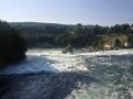
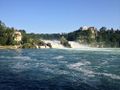
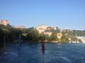
I walked back to the castle, and from there I crossed the river Rhine on the train bridge. The bridge spans the river just above the falls. I walked all around the falls on the right hand side of the stream. The view and the noise was really impressive. It's not the height of the falls, that's only 21 meters, but it's the amount of water that crashes down there. On an average summer day, 700 m3 of water pass the falls. Per second! The noise of the water is just dominating the whole scenery.
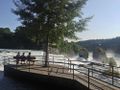
On the lower end of the falls is something like a small lake, and a few restaurants around it. So I decided to have a rest, and had a tasty salmon filet while enjoying the scenic view from the restaurant's terrace.
Next to the falls on the side towards Schaffhausen is an industrial area, which evolved there from using water power from the falls. Some pre-industrial water wheels and mills are still existing. The first aluminium factory in Europe was also located right next to the falls. Several industrial companies settled here over the centuries. From the restaurant I could see a very prominent one of them, SIG industries, which produce these things.
Photos
The way to the hash.
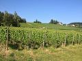
A vineyard.
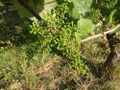
Young grapes.
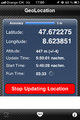
Coordinates reached.
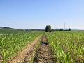
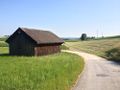
In a maize field, where the bag and the map lie.
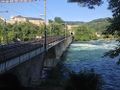
A railway bridge over the rhine.
View from the bridge.
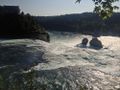
The rhine falls from above.
A very scenic place to rest.
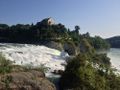
The falls and the castle.
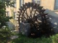
Hydro power!
View from the restaurant!
SIG factory.


Achievements
Chris_47_8 earned the Public transport geohash achievement
|
Chris_47_8 earned the Land geohash achievement
|