Difference between revisions of "2013-07-18 50 19"
From Geohashing
imported>Mkoniecz (Created page with "{{subst:Expedition |lat = 50 |lon = 19 |date = 2013-07-18 }} 2012-07-18 50 19") |
imported>FippeBot m (Location) |
||
| (6 intermediate revisions by one other user not shown) | |||
| Line 1: | Line 1: | ||
| − | |||
| − | |||
| − | |||
| − | |||
| − | |||
| − | |||
| − | |||
| − | |||
| − | |||
| − | |||
{{meetup graticule | {{meetup graticule | ||
| lat=50 | | lat=50 | ||
| Line 15: | Line 5: | ||
}} | }} | ||
| − | |||
__NOTOC__ | __NOTOC__ | ||
| − | |||
| − | |||
| − | + | [[User:mkoniecz|I]] made second attempt in this graticule, exactly one year after previous, failed one ([[2012-07-18 50 19]]). It was extremely close, so it resulted in short bicycle trip during night. | |
| − | |||
| − | |||
| − | == | + | <gallery perrow="5"> |
| − | + | Image:Hashpoint marked with bicycle.JPG | Hashpoint marked with bicycle. | |
| + | File:Confirmation image.JPG | GPSless confirmation, see [https://maps.google.com/?q=loc:50.09856614311206,19.86846027105071&ll=50.098584,19.868504&spn=0.000826,0.002642&t=m&z=19&layer=c&cbll=50.098525,19.868392&panoid=fCZgFlFdSevMZIxPYZso2A&cbp=12,16.99,,0,9.96 streetview from google] | ||
| − | |||
| − | |||
| − | |||
| − | |||
| − | |||
| − | |||
| − | |||
| − | |||
| − | |||
| − | |||
| − | |||
</gallery> | </gallery> | ||
== Achievements == | == Achievements == | ||
{{#vardefine:ribbonwidth|800px}} | {{#vardefine:ribbonwidth|800px}} | ||
| − | < | + | {{Bicycle geohash |
| + | | latitude = 50 | ||
| + | | longitude = 19 | ||
| + | | date = 2013-07-18 | ||
| + | | name = [[User:mkoniecz|mkoniecz]] | ||
| + | | distance = <2 km | ||
| + | }} | ||
| + | {{No_batteries_geohash | ||
| + | | latitude = 50 | ||
| + | | longitude = 19 | ||
| + | | date = 2013-07-18 | ||
| + | | name = [[User:mkoniecz|mkoniecz]] | ||
| + | }} | ||
| + | {{Hashiversary | ||
| + | | new = | ||
| + | | original = 2012-07-18 50 19 | ||
| + | | ordinal = | ||
| + | | name = [[User:mkoniecz|mkoniecz]] | ||
| + | | gender = his | ||
| + | | image = | ||
| − | + | }} | |
| − | |||
| − | |||
| − | |||
| − | |||
| − | |||
| − | |||
| − | |||
| − | |||
| − | |||
| − | |||
[[Category:Expeditions]] | [[Category:Expeditions]] | ||
| − | |||
[[Category:Expeditions with photos]] | [[Category:Expeditions with photos]] | ||
| − | |||
[[Category:Expedition without GPS]] | [[Category:Expedition without GPS]] | ||
| − | |||
| − | |||
| − | |||
[[Category:Coordinates reached]] | [[Category:Coordinates reached]] | ||
| − | + | {{location|PL|K|K}} | |
| − | |||
| − | |||
| − | |||
| − | |||
| − | |||
| − | |||
| − | |||
| − | |||
| − | |||
| − | |||
| − | |||
| − | |||
| − | |||
| − | |||
| − | |||
| − | |||
| − | |||
| − | |||
| − | |||
| − | |||
Latest revision as of 03:12, 14 August 2019
| Thu 18 Jul 2013 in 50,19: 50.0985661, 19.8684603 geohashing.info google osm bing/os kml crox |
I made second attempt in this graticule, exactly one year after previous, failed one (2012-07-18 50 19). It was extremely close, so it resulted in short bicycle trip during night.
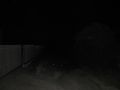
Hashpoint marked with bicycle.
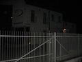
GPSless confirmation, see streetview from google


Achievements
mkoniecz earned the Bicycle geohash achievement
|
mkoniecz earned the No Batteries Geohash Achievement
|
mkoniecz earned the Hashiversary achievement
|