Difference between revisions of "2013-07-20 49 4"
imported>Beltxarga |
imported>FippeBot m (Location) |
||
| (10 intermediate revisions by 2 users not shown) | |||
| Line 10: | Line 10: | ||
== Participants == | == Participants == | ||
| − | [[user:Beltxarga|Beltxarga]] | + | * [[user:Beltxarga|Beltxarga]] |
== Plans == | == Plans == | ||
| Line 16: | Line 16: | ||
== Expedition == | == Expedition == | ||
| − | + | I arrived in Villers-Marmery at 4 pm, so a bit late for a (possible...) meetup at the geohash. I parked my car, since the plan was to walk from the village, and then go into the forest to find the geohash. On my way, I took the wrong road. At one point I reached the right latitude, but the longitude was maybe off by 500 meters. I was sweating, I had no water anymore, and I was starting to feel lost (I had wandered into the forest to try and decrease the longitude number). I decided to quit and go back to my car in the village. But on my way back, I spotted a road and after thinking for a bit, I discovered my mistake. After walking maybe 1 km along that road, I got very close to the geohash, and I wandered again into the forest. I climbed a little hill and found myself at the geohash. I think I had never sweated that much. I cancelled my visit of Verzy and Verzenay to go home, rehydrate and have a shower. | |
== Photos == | == Photos == | ||
| + | <gallery perrow="5"> | ||
| + | Image:2013-07-20 49 4 on the way1.jpg | On the way to the geohash (before the mistake). | ||
| + | Image:2013-07-20 49 4 on the way2.jpg | On the way to the geohash (before the mistake). | ||
| + | Image:2013-07-20 49 4 on the way3.jpg | On the way to... nowhere, after my orientation mistake. | ||
| + | Image:2013-07-20 49 4 longitude2.jpg | Correct latitude, only. | ||
| + | Image:2013-07-20 49 4 correct road.jpg | The correct road, on the right. | ||
| + | Image:2013-07-20 49 4 arrow.jpg | There were arrows like this all along the road, coincidence? | ||
| + | Image:2013-07-20 49 4 forest.jpg | Time to quit the road and explore! | ||
| + | Image:2013-07-20 49 4 obstacle.jpg | Last obstacle on the way up. | ||
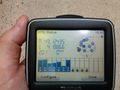
| + | Image:2013-07-20 49 4 GPS.jpg | Best coordinates I could get with my crap GPS. | ||
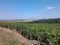
| + | Image:2013-07-20 49 4 geohash1.jpg | View from the geohash. | ||
| + | Image:2013-07-20 49 4 geohash2.jpg | View from the geohash. | ||
| + | Image:2013-07-20 49 4 geohash3.jpg | View from the geohash. | ||
| + | </gallery> | ||
== Achievements == | == Achievements == | ||
| + | {{land geohash | ||
| + | |||
| + | | latitude = 49 | ||
| + | | longitude = 4 | ||
| + | | date = 2013-07-20 | ||
| + | | name = Beltxarga | ||
| + | |||
| + | }} (thank you, [[User:Jiml|Jiml]]!) | ||
[[Category:Expeditions]] | [[Category:Expeditions]] | ||
[[Category:Expeditions with photos]] | [[Category:Expeditions with photos]] | ||
[[Category:Coordinates reached]] | [[Category:Coordinates reached]] | ||
| + | {{location|FR|51}} | ||
Latest revision as of 03:15, 14 August 2019
| Sat 20 Jul 2013 in 49,4: 49.1243548, 4.1804745 geohashing.info google osm bing/os kml crox |
Location
In a forest near Villers-Marmery, in the Montagne de Reims regional natural park.
Participants
Plans
At 2 pm, I had the idea to check if there was a geohash not too far from me. Turned out that the geohash was 20 km away, in a nice place near Villers-Marmery, so I decided to go. I wanted to visit Verzy afterwards (for the famous Faux de Verzy), and Verzenay (for its lighthouse).
Expedition
I arrived in Villers-Marmery at 4 pm, so a bit late for a (possible...) meetup at the geohash. I parked my car, since the plan was to walk from the village, and then go into the forest to find the geohash. On my way, I took the wrong road. At one point I reached the right latitude, but the longitude was maybe off by 500 meters. I was sweating, I had no water anymore, and I was starting to feel lost (I had wandered into the forest to try and decrease the longitude number). I decided to quit and go back to my car in the village. But on my way back, I spotted a road and after thinking for a bit, I discovered my mistake. After walking maybe 1 km along that road, I got very close to the geohash, and I wandered again into the forest. I climbed a little hill and found myself at the geohash. I think I had never sweated that much. I cancelled my visit of Verzy and Verzenay to go home, rehydrate and have a shower.
Photos
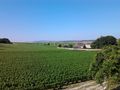
On the way to the geohash (before the mistake).
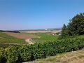
On the way to the geohash (before the mistake).
On the way to... nowhere, after my orientation mistake.
Correct latitude, only.
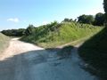
The correct road, on the right.
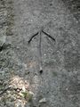
There were arrows like this all along the road, coincidence?
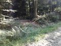
Time to quit the road and explore!
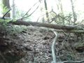
Last obstacle on the way up.
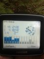
Best coordinates I could get with my crap GPS.
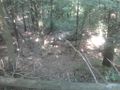
View from the geohash.
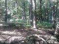
View from the geohash.
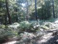
View from the geohash.


Achievements
Beltxarga earned the Land geohash achievement
|
(thank you, Jiml!)