Difference between revisions of "2013-07-21 47 8"
imported>Chris 47 8 m (ribbons added) |
imported>Chris 47 8 m (typos etc) |
||
| Line 22: | Line 22: | ||
On such a beautiful sunny sunday, i decided to go for today's hash by bike. It was about 25km from home, which is no distance. I biked there and immediately found the place. No big deal. :) The hash was in a vegetable field, but i have no idea what sort of vegatable it was. Has anyone an idea? | On such a beautiful sunny sunday, i decided to go for today's hash by bike. It was about 25km from home, which is no distance. I biked there and immediately found the place. No big deal. :) The hash was in a vegetable field, but i have no idea what sort of vegatable it was. Has anyone an idea? | ||
| − | While standing at the hashplace, i saw a small plane landing not far away. I knew that there was a small airstrip (with restaurant) | + | While standing at the hashplace, i saw a small plane landing not far away. I knew that there was a small airstrip (with restaurant) somewhere here, so I decided to go there and have an ice cream. The airfield was just on the other side of the town. While is was sitting there and enjoying my ice cream, i checked Google Maps and realized that the graticule border to 47,9 goes right thru the airfield. After i was refilled with sugar from the ice cream and a soda i biked back home. |
== Tracklog == | == Tracklog == | ||
| Line 29: | Line 29: | ||
== Photos == | == Photos == | ||
<gallery perrow="4"> | <gallery perrow="4"> | ||
| − | Image:2013-07-21_47_8_1.JPG | The hash | + | Image:2013-07-21_47_8_1.JPG | The hash was in this field. |
Image:2013-07-21_47_8_2.PNG | Coordinates reached. | Image:2013-07-21_47_8_2.PNG | Coordinates reached. | ||
Image:2013-07-21_47_8_3.JPG | Exactly here. | Image:2013-07-21_47_8_3.JPG | Exactly here. | ||
Image:2013-07-21_47_8_4.JPG | What sort of vegetable is that? | Image:2013-07-21_47_8_4.JPG | What sort of vegetable is that? | ||
| − | Image:2013-07-21_47_8_5.JPG | | + | Image:2013-07-21_47_8_5.JPG | The small airfield. |
Image:2013-07-21_47_8_6.PNG | Graticule border. | Image:2013-07-21_47_8_6.PNG | Graticule border. | ||
Image:2013-07-21_47_8_7.JPG | Parked plane, almost exactly on the graticule border. | Image:2013-07-21_47_8_7.JPG | Parked plane, almost exactly on the graticule border. | ||
Revision as of 20:09, 21 July 2013

| Sun 21 Jul 2013 in 47,8: 47.5081489, 8.9933500 geohashing.info google osm bing/os kml crox |
Location
Near the village of Lommis.
Participants
Plans
Go there by bike.
Expedition
On such a beautiful sunny sunday, i decided to go for today's hash by bike. It was about 25km from home, which is no distance. I biked there and immediately found the place. No big deal. :) The hash was in a vegetable field, but i have no idea what sort of vegatable it was. Has anyone an idea?
While standing at the hashplace, i saw a small plane landing not far away. I knew that there was a small airstrip (with restaurant) somewhere here, so I decided to go there and have an ice cream. The airfield was just on the other side of the town. While is was sitting there and enjoying my ice cream, i checked Google Maps and realized that the graticule border to 47,9 goes right thru the airfield. After i was refilled with sugar from the ice cream and a soda i biked back home.
Tracklog
n/a
Photos
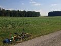
The hash was in this field.
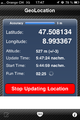
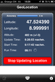
Coordinates reached.
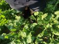
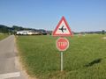
Exactly here.
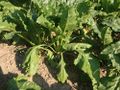
What sort of vegetable is that?
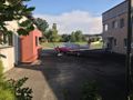
The small airfield.
Graticule border.
Parked plane, almost exactly on the graticule border.
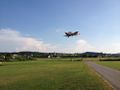
Landing plane.


Achievements
Chris_47_8 earned the Bicycle geohash achievement
|
Chris_47_8 earned the Land geohash achievement
|