Difference between revisions of "2013-07-28 48 9"
imported>GeorgDerReisende (Created page with "{{subst:Expedition |lat = 48 |lon = 9 |date = 2013-07-28 }}") |
imported>FippeBot m (Location) |
||
| (3 intermediate revisions by one other user not shown) | |||
| Line 1: | Line 1: | ||
| − | |||
| − | |||
| − | |||
| − | |||
| − | |||
| − | |||
| − | |||
| − | |||
| − | |||
| − | |||
{{meetup graticule | {{meetup graticule | ||
| lat=48 | | lat=48 | ||
| Line 18: | Line 8: | ||
__NOTOC__ | __NOTOC__ | ||
== Location == | == Location == | ||
| − | + | ||
| + | The hash lies in Ulm, Germany, in the Zinglerstraße, just a few meters south of the crossing with Neue Straße and Friedrich-Ebert-Straße. | ||
== Participants == | == Participants == | ||
| − | + | ||
| − | + | [[User:GeorgDerReisende|GeorgDerReisende]] | |
== Plans == | == Plans == | ||
| − | + | ||
| + | Because the hash lies in the middle of a lane to the traffic lights, I think the best place to be there is the sidewalk to the right, about eight meters away. Afterwards I want to travel to Potsdam, for [[2013-07-28 52 12]]. | ||
== Expedition == | == Expedition == | ||
| − | + | ||
| + | I wanted to hitchhike to Ulm from the [[2013-07-27 49 8]] meetup the evening before, then to visit the hash and to continue to hitchhike to Potsdam for the [[2013-07-28 52 12]]. But I arrived here very late. | ||
| + | |||
| + | The reasons for this had been the very heat on Saturday in Germany and some wrong planning. The distance from Nauheim to Ulm is 300 km, usually this distance is makeable to hitchhike within seven hours, starting at Nauheim at about 17:00, I should have reached Ulm at about midnight. | ||
| + | |||
| + | But I didn't. At first I tried to walk to the motorway, but it was too hot, so I have made a break in some shadow for an hour. Then I have taken the bus to Groß-Gerau, where I have bought a lot to drink. Then I went to the motorway, until now I had lost about two hours. From the junction I have taken a lift to the service station Büttelborn, where I waited for another two hours for a lift to the south, but no car for this direction appeared. After this I haven taken a lift to Darmstadt, where I have taken a tram to Alsbach and went to the service station Alsbach, where I arrived at about midnight. I have spent the night there and I gave a good nightmeal to the mosquitoes. | ||
| + | |||
| + | The next morning I left the service station at about 10:20, got a lift to the service station Sindelfinger Wald with a surprisingly detour to Karlsruhe. At Sindelfinger Wald I got after two hours of waiting a car to Neu-Ulm with an Italian couple, already discovering the possibilities of their new car. From Neu-Ulm I had to walk to Ulm, which needed two hours. | ||
| + | |||
| + | I visited the point of hash, then I thought about the next hashes I had planned to visit. | ||
| + | |||
| + | [[2013-07-28 52 12]] on the same day, but in Potsdam, had been too far away that I could reach it. | ||
| + | |||
| + | Then a new thunderstorm arrived at Ulm and I decided to rest at Ulm, but I couldn't find a cheap hostel. So I decided to travel to München and to look there for a place to stay. | ||
== Tracklog == | == Tracklog == | ||
| Line 34: | Line 39: | ||
== Photos == | == Photos == | ||
| − | |||
| − | |||
| − | |||
<gallery perrow="5"> | <gallery perrow="5"> | ||
| + | Image:2013-07-28 48 9 GeorgDerReisende 7330.jpg | Zinglerstraße in Ulm, coming down the hill | ||
| + | Image:2013-07-28 48 9 GeorgDerReisende 7331.jpg | Zinglerstraße in Ulm, going to the city | ||
| + | Image:2013-07-28 48 9 GeorgDerReisende 7332.jpg | the place of the hash | ||
| + | Image:2013-07-28 48 9 GeorgDerReisende 7335.jpg | proof | ||
| + | Image:2013-07-28 48 9 GeorgDerReisende 7339.jpg | the right side of the street | ||
| + | Image:2013-07-28 48 9 GeorgDerReisende 7342.jpg | the internet was here! | ||
</gallery> | </gallery> | ||
== Achievements == | == Achievements == | ||
{{#vardefine:ribbonwidth|800px}} | {{#vardefine:ribbonwidth|800px}} | ||
| − | |||
| + | {{Thumbs Up | latitude = 48 | longitude = 9 | date = 2013-07-28 | name = GeorgDerReisende }} | ||
| − | + | [[Category:Expeditions]] | |
| − | |||
| − | [[Category: | ||
| − | + | [[Category:Expeditions with photos]] | |
| − | |||
| − | [[Category: | ||
| − | |||
| − | |||
| − | |||
| − | |||
| − | |||
| − | |||
| − | |||
| − | |||
| − | |||
| − | |||
[[Category:Coordinates reached]] | [[Category:Coordinates reached]] | ||
| − | + | {{location|DE|BW|UL|city=true}} | |
| − | |||
| − | |||
| − | |||
| − | |||
| − | |||
| − | |||
| − | |||
| − | |||
| − | |||
| − | |||
| − | |||
| − | |||
| − | |||
| − | |||
| − | |||
| − | |||
| − | |||
Latest revision as of 06:15, 6 August 2019
| Sun 28 Jul 2013 in 48,9: 48.3964593, 9.9850709 geohashing.info google osm bing/os kml crox |
Location
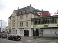
The hash lies in Ulm, Germany, in the Zinglerstraße, just a few meters south of the crossing with Neue Straße and Friedrich-Ebert-Straße.
Participants
Plans
Because the hash lies in the middle of a lane to the traffic lights, I think the best place to be there is the sidewalk to the right, about eight meters away. Afterwards I want to travel to Potsdam, for 2013-07-28 52 12.
Expedition
I wanted to hitchhike to Ulm from the 2013-07-27 49 8 meetup the evening before, then to visit the hash and to continue to hitchhike to Potsdam for the 2013-07-28 52 12. But I arrived here very late.
The reasons for this had been the very heat on Saturday in Germany and some wrong planning. The distance from Nauheim to Ulm is 300 km, usually this distance is makeable to hitchhike within seven hours, starting at Nauheim at about 17:00, I should have reached Ulm at about midnight.
But I didn't. At first I tried to walk to the motorway, but it was too hot, so I have made a break in some shadow for an hour. Then I have taken the bus to Groß-Gerau, where I have bought a lot to drink. Then I went to the motorway, until now I had lost about two hours. From the junction I have taken a lift to the service station Büttelborn, where I waited for another two hours for a lift to the south, but no car for this direction appeared. After this I haven taken a lift to Darmstadt, where I have taken a tram to Alsbach and went to the service station Alsbach, where I arrived at about midnight. I have spent the night there and I gave a good nightmeal to the mosquitoes.
The next morning I left the service station at about 10:20, got a lift to the service station Sindelfinger Wald with a surprisingly detour to Karlsruhe. At Sindelfinger Wald I got after two hours of waiting a car to Neu-Ulm with an Italian couple, already discovering the possibilities of their new car. From Neu-Ulm I had to walk to Ulm, which needed two hours.
I visited the point of hash, then I thought about the next hashes I had planned to visit.
2013-07-28 52 12 on the same day, but in Potsdam, had been too far away that I could reach it.
Then a new thunderstorm arrived at Ulm and I decided to rest at Ulm, but I couldn't find a cheap hostel. So I decided to travel to München and to look there for a place to stay.
Tracklog
Photos
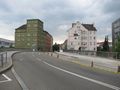
Zinglerstraße in Ulm, coming down the hill
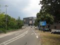
Zinglerstraße in Ulm, going to the city
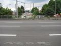
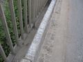
the place of the hash
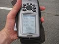
proof
the right side of the street
the internet was here!


Achievements
GeorgDerReisende earned the Thumbs Up Geohash Achievement
|