2013-07-31 66 25
From Geohashing
Revision as of 18:12, 31 July 2013 by imported>Isopekka (Created page with "thumb|left {{meetup graticule | lat=66 | lon=25 | date=2013-07-31 }} == Location == Near Hyytiäntie, in the forest behind private houses. =...")

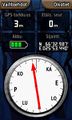
| Wed 31 Jul 2013 in 66,25: 66.5497817, 25.8906754 geohashing.info google osm bing/os kml crox |
Contents
Location
Near Hyytiäntie, in the forest behind private houses.
Participants
Expedition
- Driving total 24 km
- Walking total 0.9 km
- Expedition took 1.0 h
- Physical effort (1-5): 2
Expedition started about at 7:30 p.m. The Hashpoint situated in the forest.
Photos
The Proof.
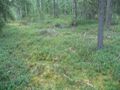
The Hash.
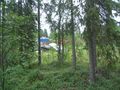
View from the hash.
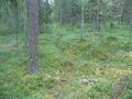
The path back to the car.


Achievements
isopekka earned the Land geohash achievement
|
Geohashing Expeditions and Plans on This Day
Expeditions and Plans
| 2013-07-31 | ||
|---|---|---|
| Fort Worth, Texas | Jason Koller | Jason Koller's first GeoHash. Near a sleepy little neighborhood by an empty... |
| Atlanta, Georgia | NWoodruff | Out back of the Mercer University campus in Chamblee. |
| Zürich, Switzerland | Calamus | A grove in Frauenfeld. |
| Rovaniemi, Finland | isopekka | Near Hyytiäntie, in the forest behind private houses. |