Difference between revisions of "2013-08-01 55 37"
From Geohashing
imported>Vb ([live picture] [http://www.openstreetmap.org/?lat=55.57029903&lon=37.45901176&zoom=16&layers=B000FTF @55.5703,37.4590]) |
imported>FippeBot m (Location) |
||
| (10 intermediate revisions by one other user not shown) | |||
| Line 19: | Line 19: | ||
== Location == | == Location == | ||
<!-- where you've surveyed the hash to be --> | <!-- where you've surveyed the hash to be --> | ||
| + | Near "Kommunarka" (new Moscow). | ||
== Participants == | == Participants == | ||
<!-- who attended: If you link to your wiki user name in this section, your expedition will be picked up by the various statistics generated for geohashing. You may use three tildes ~ as a shortcut to automatically insert the user signature of the account you are editing with. | <!-- who attended: If you link to your wiki user name in this section, your expedition will be picked up by the various statistics generated for geohashing. You may use three tildes ~ as a shortcut to automatically insert the user signature of the account you are editing with. | ||
--> | --> | ||
| − | + | [[User:Vb|vb]] | |
| − | |||
| − | |||
== Expedition == | == Expedition == | ||
<!-- how it all turned out. your narrative goes here. --> | <!-- how it all turned out. your narrative goes here. --> | ||
| + | |||
| + | Walk home-hash-bus stop. 9.9km | ||
== Tracklog == | == Tracklog == | ||
<!-- if your GPS device keeps a log, you may post a link here --> | <!-- if your GPS device keeps a log, you may post a link here --> | ||
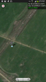
| + | [[Image:2013-08-01_55_37_vb_track.jpg|250px]] | ||
== Photos == | == Photos == | ||
| Line 39: | Line 41: | ||
<gallery perrow="5"> | <gallery perrow="5"> | ||
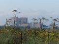
| − | Image:2013-08- | + | Image:2013-08-01_55_37_21-02-55.png | Coordinates reached [http://www.openstreetmap.org/?lat=55.57029433&lon=37.45902254&zoom=16&layers=B000FTF @55.5703,37.4590] |
Image:2013-08-01_55_37_21-02-13-405.jpg | [http://www.openstreetmap.org/?lat=55.57029903&lon=37.45901176&zoom=16&layers=B000FTF @55.5703,37.4590] | Image:2013-08-01_55_37_21-02-13-405.jpg | [http://www.openstreetmap.org/?lat=55.57029903&lon=37.45901176&zoom=16&layers=B000FTF @55.5703,37.4590] | ||
| + | |||
| + | Image:2013-08-01_55_37_21-05-22-130.jpg | [http://www.openstreetmap.org/?lat=55.57029824&lon=37.45900204&zoom=16&layers=B000FTF @55.5703,37.4590] | ||
| + | |||
| + | Image:2013-08-01_55_37_21-06-43-979.jpg | [http://www.openstreetmap.org/?lat=55.57030099&lon=37.45899537&zoom=16&layers=B000FTF @55.5703,37.4590] | ||
| + | |||
| + | Image:2013-08-01_55_37_21-07-27-963.jpg | [http://www.openstreetmap.org/?lat=55.57029866&lon=37.45901102&zoom=16&layers=B000FTF @55.5703,37.4590] | ||
| + | |||
| + | Image:2013-08-01 55 37 P1010131.jpg | ||
| + | |||
| + | Image:2013-08-01 55 37 P1010134.jpg | ||
| + | |||
| + | Image:2013-08-01 55 37 P1010140.jpg | ||
| + | |||
| + | Image:2013-08-01 55 37 P1010149.jpg | ||
| + | |||
| + | Image:2013-08-01 55 37 P1010154.jpg | ||
</gallery> | </gallery> | ||
| Line 48: | Line 66: | ||
<!-- Add any achievement ribbons you earned below, or remove this section --> | <!-- Add any achievement ribbons you earned below, or remove this section --> | ||
| + | {{consecutive geohash 2 | count = 2 | latitude = 55 | longitude = 37 | date = 2013-08-01 | name = [[User:Vb|vb]] }} | ||
| + | {{Walk geohash | latitude = 55 | longitude = 37 | date = 2013-08-01 | name = [[User:Vb|vb]] | distance = 9.9km | image = 2013-08-01_55_37_vb_track.jpg }} | ||
| − | |||
| − | |||
| − | |||
| − | |||
| − | |||
| − | |||
| − | |||
| − | |||
| − | |||
| − | |||
[[Category:Expeditions]] | [[Category:Expeditions]] | ||
| − | |||
[[Category:Expeditions with photos]] | [[Category:Expeditions with photos]] | ||
| − | |||
| − | |||
| − | |||
| − | |||
| − | |||
[[Category:Coordinates reached]] | [[Category:Coordinates reached]] | ||
| − | + | [[Category:Walk geohash achievement]] | |
| − | + | [[Category:Land geohash achievement]] | |
| − | + | {{location|RU|MOW}} | |
| − | |||
| − | |||
| − | |||
| − | |||
| − | |||
| − | |||
| − | [[Category: | ||
| − | |||
| − | |||
| − | [[Category: | ||
| − | |||
| − | |||
| − | |||
| − | |||
| − | |||
Latest revision as of 03:24, 14 August 2019
| Thu 1 Aug 2013 in 55,37: 55.5702999, 37.4590102 geohashing.info google osm bing/os kml crox |
Location
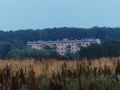
Near "Kommunarka" (new Moscow).
Participants
Expedition
Walk home-hash-bus stop. 9.9km
Tracklog

Photos
Coordinates reached @55.5703,37.4590


Achievements
vb earned the Consecutive geohash achievement
|
vb earned the Walk geohash Achievement
|