Difference between revisions of "2013-08-03 45 -121"
imported>Michael5000 |
imported>FippeBot m (Location) |
||
| (2 intermediate revisions by 2 users not shown) | |||
| Line 8: | Line 8: | ||
}} | }} | ||
| − | + | ||
__NOTOC__ | __NOTOC__ | ||
== Location == | == Location == | ||
| Line 16: | Line 16: | ||
== Participants == | == Participants == | ||
| − | [[User:Michael5000|Michael5000]] | + | * [[User:Michael5000|Michael5000]] |
== Expedition == | == Expedition == | ||
| Line 25: | Line 25: | ||
== Photos == | == Photos == | ||
| − | + | ||
| − | |||
| − | |||
<gallery perrow="5"> | <gallery perrow="5"> | ||
File:2013-08-03 45 -121 View.JPG|Looking Eastward up the Gorge | File:2013-08-03 45 -121 View.JPG|Looking Eastward up the Gorge | ||
| Line 36: | Line 34: | ||
== Achievements == | == Achievements == | ||
{{#vardefine:ribbonwidth|800px}} | {{#vardefine:ribbonwidth|800px}} | ||
| − | + | ||
| + | * Michael5000's First Expedition to Klickitat County and to the Washington side of The Dalles graticule. | ||
{{Multihash2 | count = 2 | date = 2013-08-03 | name = [[User:Michael5000|Michael5000]] }} | {{Multihash2 | count = 2 | date = 2013-08-03 | name = [[User:Michael5000|Michael5000]] }} | ||
| − | |||
[[Category:Expeditions]] | [[Category:Expeditions]] | ||
[[Category:Expeditions with photos]] | [[Category:Expeditions with photos]] | ||
[[Category:Coordinates reached]] | [[Category:Coordinates reached]] | ||
| + | {{location|US|WA|KL}} | ||
Latest revision as of 03:26, 14 August 2019

| Sat 3 Aug 2013 in 45,-121: 45.7169253, -121.3540812 geohashing.info google osm bing/os kml crox |
Location
Uphill from Old Highway 8 on the Washington side of the Columbia Gorge.
Participants
Expedition
Heading east out of Portland, I spaced out and took the Bridge of the Gods rather than the Hood River Bridge to the Washington side, which kept me in relatively slow Highway 14 traffic for an extra 20 miles. No worries. Old Highway 8, once I got there, was an entertainingly narrow, winding road, probably of 1920s vintage or so. There was a gated turnoff that give me a good place to park, and a convenient track running about 1/3 mile up through recently burnt-over grassland. The whole walk to the hashpoint and back had terrific views of the Columbia Gorge.
Subsequently, I drove a long way and got in a second hashpoint in suburban Boise.
Photos
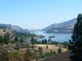
Looking Eastward up the Gorge
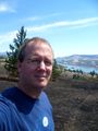
Michael5000
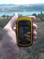
The new gadget registers its second win


Achievements
- Michael5000's First Expedition to Klickitat County and to the Washington side of The Dalles graticule.
Michael5000 earned the Multihash Achievement
|