Difference between revisions of "2013-08-05 44 -110"
imported>Michael5000 (→Location) |
m (per Renaming Proposal) |
||
| (11 intermediate revisions by 5 users not shown) | |||
| Line 1: | Line 1: | ||
| − | |||
| − | |||
| − | |||
| − | |||
| − | |||
| − | |||
| − | |||
| − | |||
| − | |||
{{meetup graticule | {{meetup graticule | ||
| lat=44 | | lat=44 | ||
| Line 25: | Line 16: | ||
* [[User:Michael5000|Michael5000]] | * [[User:Michael5000|Michael5000]] | ||
| − | == | + | == Expedition == |
| − | + | ||
| + | I started the day in Idaho Falls, scanning the hashpoints for inspiration, and the hashpoints said "GO NORTH!!!" | ||
| + | |||
| + | After a little knocking around in Northeastern Idaho, I crossed into Montana and then in the West Entrance to Yellowstone National Park. This required an entrance fee (Figure 1). The woman at the entrance booth had a long speech that she must give a thousand times a day about how my receipt would allow re-entrance for a week, yadda yadda yadda, and made to hand me a thick stack of park publications. "I don't really need any materials," I said. "I'm only going in for an hour or so." She pulled them back with an air of thinking that this was REALLY WEIRD and probably wrong, but not worth arguing over. | ||
| + | |||
| + | Now, the hashpoint was on the north bank of the Madison River, and I knew that near the entrance the Madison has a gently sloping, lightly forested bank (Figure 2). What I didn't know was that closer to the bridge that was my access to the north bank, the bank gets steeper. Much, much steeper. It is, in fact, about a 40 degree slope of loose scree, capped by a formidable stone palisade (Figure 3). | ||
| + | |||
| + | I was getting nervous, and warnings regarding unfamiliar bears didn't help (Figure 4). But, there was a nice little trail heading in the right direction... (Figure 5) | ||
| + | |||
| + | What followed was an object lesson in pursuing geohashing for the journey, not the destination. The trail only got me within 400 feet of the hashpoint, which was clearly up on top of the canyon. But, I thought I saw a break in the palisade, and decided to give climbing up the wall a shot. | ||
| + | |||
| + | Friends, climbing up a steep scree slope is kind of dumb, unless you are darn sure you can get back down. And the stupid thing I did was reach three separate decision points where I wasn't 100% confident I'd be able to get back down, and kept going up. It was only when I got to the palisade, and my fourth decision point, that I started to think things like "I could be out here with a broken leg for a hella long time with nobody noticing" and "For that matter, no one on the planet has the slightest idea where I am" and "Golly, [[User:Mrs.5000|Mrs.5000]] sure would be glum if I copped it" and even "If I had to be airlifted out, it would be some nasty publicity for the Geohashing community." | ||
| − | + | In truth, I probably could have made it the rest of the way up, claimed the point, and handled the descent. But only probably. And, I'm not surprised I made it down without consequences, although it was tricky business and scary as hell. I could probably make that descent without consequences 99 times out of 100. But the 1 out of 100 would really take the fun out the enterprise. So I've resolved to, from here on out, take pride in my thwarted expeditions. After all, an expedition is only thwarted because I'm respecting somebody's fence, or because I'm smart enough not to push my luck in adverse conditions. From now on, my goal is to stay smart, and always come home. | |
| − | |||
| − | + | After a short rest stop to get my blood pressure back to normal, I continued on to the gentler terrain of [[2013-08-05 45 -110]]. | |
| − | |||
== Photos == | == Photos == | ||
| − | + | ||
| − | |||
| − | |||
<gallery perrow="5"> | <gallery perrow="5"> | ||
| + | File:2013-08-05 44 -110 1.JPG|Figure 1 | ||
| + | File:2013-08-05 44 -110 2.JPG|Figure 2 | ||
| + | File:2013-08-05 44 -110 3.JPG|Figure 3 | ||
| + | File:2013-08-05 44 -110 4.JPG|Figure 4 | ||
| + | File:2013-08-05 44 -110 5.JPG|Figure 5 | ||
</gallery> | </gallery> | ||
== Achievements == | == Achievements == | ||
| + | |||
| + | * First ever attempt on the [[Yellowstone, Wyoming]] graticule. All those people having boring normal vacations.... | ||
| + | |||
{{#vardefine:ribbonwidth|800px}} | {{#vardefine:ribbonwidth|800px}} | ||
| − | + | {{Admit One geohash | |
| + | |||
| + | | latitude = 44 | ||
| + | | longitude = -110 | ||
| + | | date = 2013-08-05 | ||
| + | | name = [[User:Michael5000|Michael5000]] | ||
| + | | price = US$25.00 | ||
| + | | venue = Yellowstone National Park | ||
| + | | image = 2013-08-05 44 -110 1.JPG | ||
| + | |||
| + | }} | ||
| + | {{done with nature | ||
| + | | latitude = 44 | ||
| + | | longitude = -110 | ||
| + | | date = 2013-08-05 | ||
| + | | name = [[User:Michael5000|Michael5000]] | ||
| + | }} | ||
| − | |||
| − | |||
| − | |||
| − | |||
| − | |||
| − | |||
| − | |||
| − | |||
[[Category:Expeditions]] | [[Category:Expeditions]] | ||
| − | |||
[[Category:Expeditions with photos]] | [[Category:Expeditions with photos]] | ||
| − | |||
| − | |||
| − | |||
| − | |||
| − | |||
| − | |||
| − | |||
| − | |||
| − | |||
[[Category:Coordinates not reached]] | [[Category:Coordinates not reached]] | ||
| − | |||
| − | |||
[[Category:Not reached - Mother Nature]] | [[Category:Not reached - Mother Nature]] | ||
| − | + | {{location|US|WY|PA}} | |
| − | |||
| − | |||
| − | |||
| − | |||
| − | |||
| − | |||
| − | |||
| − | |||
| − | |||
| − | |||
Latest revision as of 14:33, 2 April 2024
| Mon 5 Aug 2013 in 44,-110: 44.6693250, -110.9701443 geohashing.info google osm bing/os kml crox |
Location
Near the West Entrance of Yellowstone National Park.
Participants
Expedition
I started the day in Idaho Falls, scanning the hashpoints for inspiration, and the hashpoints said "GO NORTH!!!"
After a little knocking around in Northeastern Idaho, I crossed into Montana and then in the West Entrance to Yellowstone National Park. This required an entrance fee (Figure 1). The woman at the entrance booth had a long speech that she must give a thousand times a day about how my receipt would allow re-entrance for a week, yadda yadda yadda, and made to hand me a thick stack of park publications. "I don't really need any materials," I said. "I'm only going in for an hour or so." She pulled them back with an air of thinking that this was REALLY WEIRD and probably wrong, but not worth arguing over.
Now, the hashpoint was on the north bank of the Madison River, and I knew that near the entrance the Madison has a gently sloping, lightly forested bank (Figure 2). What I didn't know was that closer to the bridge that was my access to the north bank, the bank gets steeper. Much, much steeper. It is, in fact, about a 40 degree slope of loose scree, capped by a formidable stone palisade (Figure 3).
I was getting nervous, and warnings regarding unfamiliar bears didn't help (Figure 4). But, there was a nice little trail heading in the right direction... (Figure 5)
What followed was an object lesson in pursuing geohashing for the journey, not the destination. The trail only got me within 400 feet of the hashpoint, which was clearly up on top of the canyon. But, I thought I saw a break in the palisade, and decided to give climbing up the wall a shot.
Friends, climbing up a steep scree slope is kind of dumb, unless you are darn sure you can get back down. And the stupid thing I did was reach three separate decision points where I wasn't 100% confident I'd be able to get back down, and kept going up. It was only when I got to the palisade, and my fourth decision point, that I started to think things like "I could be out here with a broken leg for a hella long time with nobody noticing" and "For that matter, no one on the planet has the slightest idea where I am" and "Golly, Mrs.5000 sure would be glum if I copped it" and even "If I had to be airlifted out, it would be some nasty publicity for the Geohashing community."
In truth, I probably could have made it the rest of the way up, claimed the point, and handled the descent. But only probably. And, I'm not surprised I made it down without consequences, although it was tricky business and scary as hell. I could probably make that descent without consequences 99 times out of 100. But the 1 out of 100 would really take the fun out the enterprise. So I've resolved to, from here on out, take pride in my thwarted expeditions. After all, an expedition is only thwarted because I'm respecting somebody's fence, or because I'm smart enough not to push my luck in adverse conditions. From now on, my goal is to stay smart, and always come home.
After a short rest stop to get my blood pressure back to normal, I continued on to the gentler terrain of 2013-08-05 45 -110.
Photos
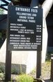
Figure 1
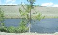
Figure 2

Figure 3
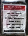
Figure 4
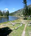
Figure 5


Achievements
- First ever attempt on the Yellowstone, Wyoming graticule. All those people having boring normal vacations....


Michael5000 earned the Done with Nature consolation prize
|