Difference between revisions of "2013-08-07 32 -117"
imported>Mathgeek m (→Expedition) |
imported>FippeBot m (Location) |
||
| (21 intermediate revisions by 2 users not shown) | |||
| Line 19: | Line 19: | ||
== Location == | == Location == | ||
<!-- where you've surveyed the hash to be --> | <!-- where you've surveyed the hash to be --> | ||
| + | |||
| + | Atop a ridge off the end of Santa Era in Rancho Encantada, an under-development road and residential zone on the south side of Beeler Canyon in San Diego, CA just south of the border with Poway | ||
| + | |||
| + | <!-- * Open area I think part of Mission Trails Regional Park (MTRP) not far from trail head parking at the end of Stonebridge Parkway. Should be a short walk to the location. You can geocache on your way to the geohash as well. -- [[User:Mathgeek|Mathgeek]] ([[User talk:Mathgeek|talk]]) 09:29, 7 August 2013 (PDT) --> | ||
== Participants == | == Participants == | ||
<!-- who attended: If you link to your wiki user name in this section, your expedition will be picked up by the various statistics generated for geohashing. You may use three tildes ~ as a shortcut to automatically insert the user signature of the account you are editing with. | <!-- who attended: If you link to your wiki user name in this section, your expedition will be picked up by the various statistics generated for geohashing. You may use three tildes ~ as a shortcut to automatically insert the user signature of the account you are editing with. | ||
--> | --> | ||
| + | |||
| + | *[[User:Mathgeek|Mathgeek]] ([[User talk:Mathgeek|talk]]) | ||
| + | |||
| + | *[[User:LucasBrown|LucasBrown]] (independent expedition) | ||
== Plans == | == Plans == | ||
| Line 28: | Line 36: | ||
*This can happen today. Accessible and convenient. -- [[User:Mathgeek|Mathgeek]] ([[User talk:Mathgeek|talk]]) 09:11, 7 August 2013 (PDT) | *This can happen today. Accessible and convenient. -- [[User:Mathgeek|Mathgeek]] ([[User talk:Mathgeek|talk]]) 09:11, 7 August 2013 (PDT) | ||
| + | |||
| + | *Going to a doctor's appointment now and will hit the hashpoint on the way back. Should get to the closest vehicular approach or the end of Stonebridge Parkway (depending on whether I feel like climbing up and down two 200' steepish hills) at 15:10 or so and will walk to the hashpoint from there. -- [[User:LucasBrown|LucasBrown]] | ||
== Expedition == | == Expedition == | ||
| − | + | [[User:LucasBrown|LucasBrown]]: I went to the closest vehicular approach—a spot along Via Santa Pradera—at about 15:30 and took my time hiking a few hundred meters across a small valley to reach the hashpoint (reaching it at 15:52) before to the car by walking along the ridgelines under the gentle cooling of a light breeze. I crossed paths with another hiker wearing a dark blue T-shirt and jeans shorts but didn't stop to say hi or anything because speech issues. | |
| + | |||
| + | *Made it! -- [[User:Mathgeek|Mathgeek]] ([[User talk:Mathgeek|talk]]) [http://www.openstreetmap.org/?lat=32.93441601&lon=-117.00763027&zoom=16&layers=B000FTF @32.9344,-117.0076] 18:53, 7 August 2013 (PDT) | ||
== Tracklog == | == Tracklog == | ||
<!-- if your GPS device keeps a log, you may post a link here --> | <!-- if your GPS device keeps a log, you may post a link here --> | ||
| Line 40: | Line 52: | ||
--> | --> | ||
<gallery perrow="5"> | <gallery perrow="5"> | ||
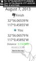
| + | Image:2013-08-07_32_-117_16-48-54-661.jpg | ([[User:LucasBrown|LucasBrown]]) Geohash Droid details page at hashpoint | ||
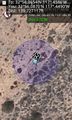
| + | Image:2013-08-07_32_-117_16-50-08-277.jpg | ([[User:LucasBrown|LucasBrown]]) Regional map at hashpoint | ||
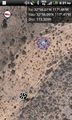
| + | Image:2013-08-07_32_-117_16-50-37-658.jpg | ([[User:LucasBrown|LucasBrown]]) Local map at hashpoint | ||
| + | |||
| + | Image:2013-08-07_32_-117_16-52-43-092.jpg | ([[User:LucasBrown|LucasBrown]]) The view southwest from the hashpoint | ||
| + | |||
| + | Image:2013-08-07_32_-117_16-53-32-022.jpg | ([[User:LucasBrown|LucasBrown]]) Sign posted near the hashpoint at the end of Stonebridge Parkway | ||
| + | |||
| + | Image:2013-08-07_32_-117_18-56-17-582.jpg | Woohoo! [http://www.openstreetmap.org/?lat=32.93444353&lon=-117.00765559&zoom=16&layers=B000FTF @32.9344,-117.0077] | ||
| + | |||
| + | Image:2013-08-07_32_-117_18-56-57-566.jpg | Yay! [http://www.openstreetmap.org/?lat=32.93478287&lon=-117.00748310&zoom=16&layers=B000FTF @32.9348,-117.0075] | ||
| + | |||
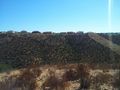
| + | Image:2013-08-07_32_-117_19-32-04-494.jpg | Nearby geocache location. | ||
</gallery> | </gallery> | ||
== Achievements == | == Achievements == | ||
{{#vardefine:ribbonwidth|800px}} | {{#vardefine:ribbonwidth|800px}} | ||
| − | + | {{Hash collision | latitude = 32 | longitude = -117 | date = 2013-08-07 | name = Mathgeek | link = http://www.geocaching.com/seek/cache_details.aspx?wp=GC48BZK | id = GC48BZK | distance = 173 ft}} | |
| + | {{Consecutive geohash | count = 2 | latitude = 32 | longitude = -117 | date = 2013-08-07 | name = LucasBrown}} | ||
| − | |||
| − | |||
| − | |||
| − | |||
| − | |||
| − | |||
| − | |||
| − | |||
| − | |||
| − | |||
[[Category:Expeditions]] | [[Category:Expeditions]] | ||
| − | |||
[[Category:Expeditions with photos]] | [[Category:Expeditions with photos]] | ||
| − | |||
| − | |||
| − | |||
| − | |||
| − | |||
[[Category:Coordinates reached]] | [[Category:Coordinates reached]] | ||
| − | + | <!-- Leaving these category markers in with comment tags in case they apply to other hashers ---LucasBrown --> | |
| − | --><!-- | + | <!--[[Category:Expeditions with videos]] [[Category:Expedition without GPS]]--> |
| − | [[Category: | + | <!--[[Category:Coordinates not reached]] [[Category:Not reached - Mother Nature]] [[Category:Not reached - No public access]] [[Category:Not reached - Technology]] [[Category:Not reached - Did not attempt]]--> |
| − | -- | + | {{location|US|CA|SD}} |
| − | |||
| − | [[Category:Not reached - Mother Nature]] | ||
| − | |||
| − | |||
| − | [[Category:Not reached - No public access]] | ||
| − | |||
| − | |||
| − | [[Category:Not reached - Technology]] | ||
| − | |||
| − | |||
| − | [[Category:Not reached - Did not attempt]] | ||
| − | |||
| − | |||
Latest revision as of 03:30, 14 August 2019
| Wed 7 Aug 2013 in 32,-117: 32.9344231, -117.0076424 geohashing.info google osm bing/os kml crox |
Location
Atop a ridge off the end of Santa Era in Rancho Encantada, an under-development road and residential zone on the south side of Beeler Canyon in San Diego, CA just south of the border with Poway
Participants
- LucasBrown (independent expedition)
Plans
- Going to a doctor's appointment now and will hit the hashpoint on the way back. Should get to the closest vehicular approach or the end of Stonebridge Parkway (depending on whether I feel like climbing up and down two 200' steepish hills) at 15:10 or so and will walk to the hashpoint from there. -- LucasBrown
Expedition
LucasBrown: I went to the closest vehicular approach—a spot along Via Santa Pradera—at about 15:30 and took my time hiking a few hundred meters across a small valley to reach the hashpoint (reaching it at 15:52) before to the car by walking along the ridgelines under the gentle cooling of a light breeze. I crossed paths with another hiker wearing a dark blue T-shirt and jeans shorts but didn't stop to say hi or anything because speech issues.
- Made it! -- Mathgeek (talk) @32.9344,-117.0076 18:53, 7 August 2013 (PDT)
Tracklog
Photos
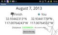
(LucasBrown) Geohash Droid details page at hashpoint
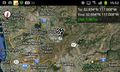
(LucasBrown) Regional map at hashpoint
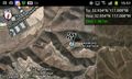
(LucasBrown) Local map at hashpoint
(LucasBrown) The view southwest from the hashpoint
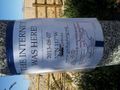
(LucasBrown) Sign posted near the hashpoint at the end of Stonebridge Parkway
Woohoo! @32.9344,-117.0077
Yay! @32.9348,-117.0075
Nearby geocache location.


Achievements
Mathgeek earned the Hash collision achievement
|
LucasBrown earned the Consecutive geohash achievement
|